Fun waves into the end of the week with good surf from Monday afternoon onwards

Victoria Forecast by Craig Brokensha (issued Wednesday 7th May)
Best Days: Thursday, Friday morning, Monday afternoon, Tuesday, Wednesday
Recap
A strong pulse of S/SW groundswell filled in yesterday, building from 4-5ft on the Surf Coast and 8ft on the Mornington Peninsula, but the Torquay region was the only area offering any decent conditions with a light W'ly breeze during the morning. After that a strong S/SW change moved through, limiting the best waves to protected bays and points as the swell kicked further into the afternoon.
A drop in size is being seen today with lingering onshores from the S/SE creating poor conditions across both coasts.
This week and weekend (Apr 7 – Apr 11)
Today's swell will continue to back off into tomorrow, but steady through the afternoon as a long-range and very inconsistent SW groundswell fills in. This should provide 2-3ft waves across the Surf Coast for most of the day and 4-5ft waves on the Mornington Peninsula. Conditions will be best east of Melbourne and on the Surf Coast beaches with a N/NE wind that should persist most of the day.
Come Friday the swell will become small on the Surf Coast and remain fun east of Melbourne under fresh N/NE tending N'ly winds.
Saturday will be best left for beginners as the swell bottoms out (probably holding 2ft+ on the Mornington Peninsula) under fresh N/NW tending W/NW winds.
Come Sunday a new W'ly swell that was due later in the day and more so Monday has been brought forward a touch, with the swell now due to be in the water Sunday morning.
The source of this swell will be a vigorous mid-latitude front dipping south-east from WA, generating a broad fetch of strong to gale-force W/SW winds through our western swell window tomorrow evening and Friday.
The W'ly direction will not be favourable for the Surf Coast, with small 2ft waves due around Torquay, while 13th Beach should offer bigger 3ft sets. The Mornington Peninsula will provide the most size with 4-6ft sets, but W/NW tending SW winds will favour the more protected breaks on the Surf Coast.
Monday onwards (Apr 12 onwards)
Sunday's W'ly swell is due to dip temporarily into Monday morning ahead of a strong long-range increase in W/SW groundswell through the day.
The source of this swell is a vigorous polar frontal progression in our far swell window over near Heard Island.
Yesterday and this morning, an initial polar low generated a fetch of 35-50kt winds, setting in motion a large and active sea state as well as an initial small long-period swell for Sunday. The buoys will pick this up during the morning but no major size is due and any increase will be seen through the afternoon. A secondary system will quickly race in over the top of this active sea state, generating an additional fetch of 35-45kt+ W/SW winds while projecting towards WA.
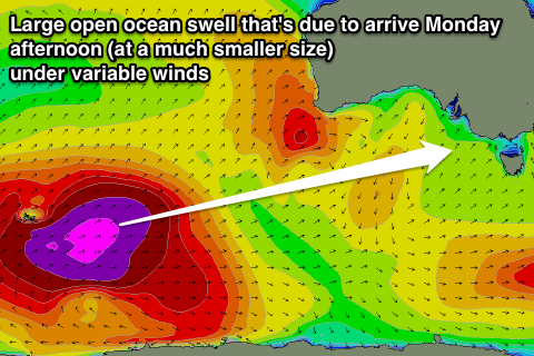 This should set in motion a large and powerful but long-range W/SW groundswell that should arrive Monday morning and build strongly during the afternoon, reaching a really inconsistent but strong 3-4ft on the Surf Coast and 6ft to possibly 8ft by dark on the Mornington Peninsula.
A peak in size is due overnight, but Tuesday will still provide similar sized waves as a flurry of secondary frontal activity being pushed towards WA and then deflected back down towards the poles continues to send W/SW swell our way.
Wind wise, Monday looks best of the Surf Coast, but also favourable for the Mornington Peninsula into the afternoon with a light to moderate NW tending variable wind. Come Tuesday as the swell slowly eases, local offshores across both coasts should create great conditions and then Wednesday should see N/NW tending variable winds again.
Longer term there's nothing too major on the cards until possibly Tuesday/Wednesday the following week, but we'll have another look at this on Friday.