Southerly bluster
Southerly bluster
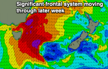
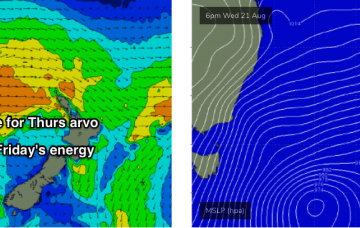
The larger, much more powerful surf will probably push into the Mid North Coast during the afternoon, but may not reach the Northern Rivers until overnight. More in the Forecaster Notes.
A vigorous frontal passage across the SE corner of the state will reach maximum strength early Thursday as a broad fetch of 50-60kt SW winds exit eastern Bass Strait. More in the Forecaster Notes.
Windy and large surf developing tomorrow, pumping as it eases.
Onshore and solid waves tomorrow, cleaner as the swell eases on Friday and fun for the weekend.
Large swells over the coming period with better winds for longer periods of time. Only for the experienced.
Onshore and solid tomorrow but much better Friday as the surf starts to ease. A mix of winds and swells for the weekend.
Large and windy surf tomorrow, easing and improving into the end of the week ahead of a slower weekend with varying winds as a trough moves through. Some fun surf days next week.
On Thursday, we’ll really start to see surf size increase through the day - initially across the Mid North Coast - before wave heights max out on Friday. More in the Forecaster Notes.
We’re just starting to see the early signs of fresh southerly swell activity, and this will translate to a slow building trend through Tuesday and Wednesday ahead of step-ladder increases into Thursday and Friday. More in the Forecaster Notes.
Moderate to large southerly groundswell event to finish off the week with improving winds.