Plenty of size and wind for Father's Day weekend, slowly settling into next week with better options

freeride76

Plenty of size and wind for Father's Day weekend, slowly settling into next week with better options

freeride76

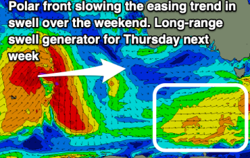
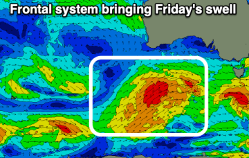
Complex and dynamic weekend ahead, with an upper trough, surface trough and front forming a surface low in the convergence off the North Coast. The initial front now feeds into a deepening trough line off the Mid North Coast (separate to the developing surface low off the North Coast ) which amplifies the fetch of S/SE winds adjacent to the Central NSW Coast.

Solid S swell pulses over the weekend and into next week as polar low passes through Southern Ocean

freeride76

Solid S swell pulses over the weekend and into next week as polar low passes through Southern Ocean

freeride76

The current pattern- with weak high pressure drifting across Central NSW and a soft ridge along the coast- will be replaced in emphatic fashion by a much stronger front and trough on Friday, forming a surface low off the Mid North Coast, anchored by a monster high moving into the Bight at the same time. Well to the south of that set-up will be a deep polar low and associated fronts with severe gales to storm force winds generating long period S’ly swells to make landfall over the weekend and into early next week.

Small surf ends this weekend with large, windy S swell on the radar

freeride76

Small surf ends this weekend with large, windy S swell on the radar

freeride76

The current pattern- with weak high pressure drifting across Central NSW and a soft ridge along the coast- will be replaced in emphatic fashion by a much stronger front and trough on Friday, forming a surface low off the Mid North Coast, anchored by a monster high moving into the Bight at the same time. Well to the south of that set-up will be a deep polar low and associated fronts with severe gales to storm force winds generating long period S’ly swells to make landfall early next week.

Weak swells ending Fri with plenty of size from the South ahead

freeride76

Weak swells ending Fri with plenty of size from the South ahead

freeride76

The current pattern- with weak high pressure drifting across Central NSW and a soft ridge along the coast- will be replaced in emphatic fashion by a much stronger front and trough on Friday, anchored by a monster high moving into the Bight at the same time. Well to the south of that set-up will be a deep polar low and associated fronts with severe gales to storm force winds generating long period S’ly swells to make landfall early next week.