Fun week of beachbreaks ahead

Sydney Hunter Illawarra Surf Forecast by Ben Matson (issued Monday Dec 13th)
Forecast Summary (tl;dr)
- Steadily easing SE swell Tues, bottoming out Wed with small beachies, clean both days with early light winds
- Small renewal of SE swell Thurs, marginally bigger pulse Fri, clean with early light winds
- Building NE windswell Sat, but bumpy
- NE swell showing best early Sun with light morning winds
Recap
We’ve seen three days of large waves across Southern NSW, with swell direction initially holding from the south but veering S/SE into Sunday and more SE today. Most days held in and around the 5-6ft+ range at south facing beaches though some coasts saw bigger waves at times, and this morning saw a slightly broader coverage of maximum surf size thanks to the additional easterly component in the swell direction. Each days winds were similar - mainly early W/SW thru’ SW, tending S’ly through the day. Surf size is now starting to ease.
This week (Dec 14 - 17)
The Tasman Low responsible for our three-day swell event began easing late Sunday so we’ll see a corresponding easing of surf size from now onwards. Indeed, the downwards trend has already begun.
Tuesday morning should still manage 3-4ft+ sets at exposed beaches, but we’ll be down to 2-3ft by the afternoon and Wednesday will probably level out at around 2ft+ or so at the swell magnets. Protected southern ends will be smaller.
Light winds and sea breezes are expected both days so expect the best surf conditions to occur in the mornings.
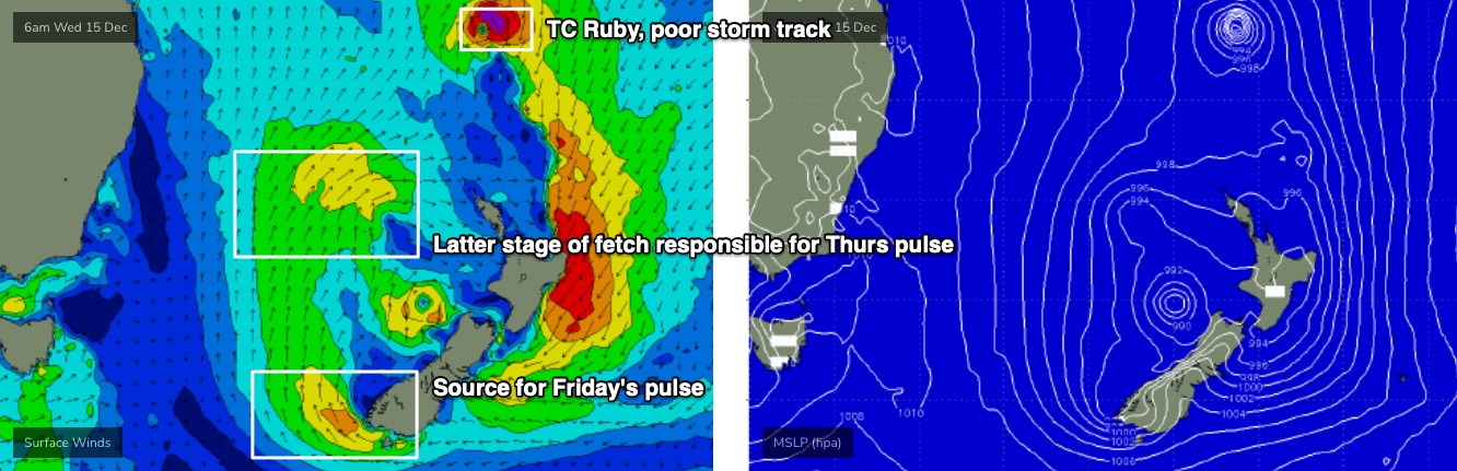
Although the Tasman Low is weakening, it will become absorbed into a broad surface trough spanning the greater Tasman Sea, and a redeveloping multi-centered surface low east of Cook Strait on Tuesday will see several off-axis fetches develop in the eastern Tasman Sea, that will bring about a minor pulse of sideband SE energy for Thursday.
This fetch is mainly aimed towards the North Coast, so we’ll probably see the most size potential north from Sydney, perhaps with sets around the 2-3ft, and smaller surf south from about Sydney. Expect smaller wave heights at beaches not completely open to the south.
It’s a low percentage event too, so expect long breaks between sets, and keep your expectations low.
A similar secondary pulse of SE swell (from a seperate fetch off the SW tip of the South Island, see below) is then expected on Friday; this one looks marginally better - perhaps a smidge more size - though I’d be hesitant in getting your hopes up for anything amazing. However it should provide a broader coverage of size across Southern NSW due to the more southern position of the fetch.
As for conditions, a shallow southerly change is expected to push through sometime Thursday morning, though without much strength. Early morning should offer light winds and clean conditions.
Similarly light winds are expected Friday morning ahead of NE sea breezes.
And just to reiterate from Friday’s notes, TC Ruby and its extra-tropical stages won’t offer any notable surf for Southern NSW.
This weekend (Dec 18 - 19)
Freshening NE winds on Saturday will generate some local windswell for the coast, though conditions will be poor under the accompanying breeze.
A trough is expected to cross the coast overnight Saturday, which should lead to a morning window of clean conditions and peaky 2-3ft+ NE swell that’ll offer fun peaky beach breaks.
That's the pick of the weekend at this stage. Flag Saturday and aim for the early session on Sunday.
Next week (Dec 20 onwards)
The Southern Ocean storm track looks out of whack for Southern NSW into the long term.
A powerful low pushing under Tasmania this weekend looks impressive in single synoptic snapshots, but we’ll probably just see some minor glancing long period energy at a handful of south swell magnets (Mon/Tues).
Elsewhgere, and the lead to Xmas is looking a little on the quiet side. So, make the most of the next few days.
More on all of this in Wednesday’s forecast.