Make the most of the weekend of waves
Sydney Hunter Illawarra Surf Forecast by James Casey (issued Friday 4th June)
Best Days: Saturday and Sunday morning
Outlook (tl;dr)
- S swell peaking tomorrow (Saturday) with improving conditions in the afternoon
- Smaller but cleaner leftover S swell for Sunday
- Not much for start of next week, likely to be the smallest it’s been all year
- Interesting setup for late next week with potential for a run of E/NE swell from Thursday onwards
Recap
The swell really dropped off yesterday with only small waves below 2ft on offer by the afternoon. Winds were light and offshore all day though with the drizzle of rain keeping crowds away.
Today the swell is micro, lucky to be 1ft on the sets at the moment and with a bit of SW wind already making it a little bumpy for northern ends.
Into the weekend 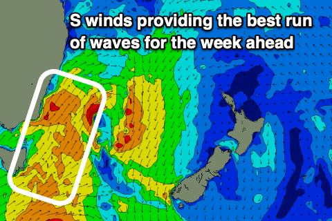
The swell should increase throughout the day today thanks to a double headed cold front. There was an initial front that moved through this morning more out of the west before the second head of the front is set to push through with more southerly wind later today. This second front is where the swell will be generated with a fetch pushing up along the coast and providing a kick for tomorrow morning.
Compared to models on Wednesday the swell is looking to arrive a bit later this arvo so there’ll be less size for the late. Up to 3ft at S swell magnets, but it’ll be bumpy. Better options will exist over the weekend.
The S swell will peak tomorrow (Saturday) morning up around the 4-6ft mark at S swell magnets but winds will still be fairly strong out of the W/SW to SW. I’d expect a bit of bump on it for the swell magnets but beaches that are clean in SW winds will have some decent waves on offer. It’ll be smaller in these cleaner spots but something worth getting wet for.
Winds will ease later in the day turning offshore and then light and variable out of the NE. This will mean it’ll be your best chance for clean conditions and a bit of size. The swell will ease as the day goes on but I’d still expect some 4ft sets by the afternoon at S swell magnets.
Sunday will see W/SW winds early tending more W and easing as the day goes on. The swell will be smaller, around 3ft early easing to 2ft by the afternoon for S swell magnets.
It’ll be the best chance of waves for a little while as a spell of smaller waves takes over for the start of next week.
Next week
What’s left of the S/SE swell will be all that’s on offer for the start of next week. It’s not looking great with small waves best at S swell magnets but it’ll be micro. Winds will be offshore early before strengthening out of the N later in the day.
I’m looking for something to get excited about for the rest of the week but really there’s not much from Monday until Thursday. The N winds on Monday afternoon look a little too N and not enough E so any swell generated will sail on by. There’s some E winds in the eastern Tasman with a low over NZ’s North Island on Monday/Tuesday but it’s not looking like a long enough fetch and even if it did have a decent fetch it wouldn’t arrive until Thursday anyway.
Instead it’s looking like the worst run of waves we’ve had all year which highlights how good we’ve had it. It’ll be a good time to catch up on any chores you’ve neglected for the past six months.
Things look to spring back to life sometime on Thursday and into Friday thanks to a cut off low moving over land with some cold air. There’ll be an infeed of NE winds towards the coast allowing a new E/NE swell looking best for the South Coast.
It’s a fair way out and a bit of model disagreement so let’s not get too excited about it but at this stage it’s looking like we’ll have 3ft of E/NE swell and N/NW to W/NW winds. What is certain is it is looking better than the start of the week.
Tune in on Monday for an update.
Comments
Cmon Huey. Keep it coming.
Yeah, I've been going in to work late, more often than not, for the last few months. Been blaming it on the kids...
Good chance to give that a rest.
Cracking waves this arvo on a insane rip bowl .. with a couple of mates .. all the boys were absolutely frothing.. beers taste good this arvo
Water temp has jumped a couple of degrees in Sydney, so nice. Clear and warm.
Still in a springy when the sun is out.. water temperatures spot on .. a bloke in board shorts nothing else sat .. surfed 2hrs .. will definitely change soon , SW winds cut ya in half when ya wet
Not the best for surf though unless you're in the deep South, but then you'll be copping the wind..
Hey Craig, rather unusual set up to linger over us rather than turn into an ECL? Think the models will change?
It's all about the positioning.
For far southern NSW and more so south-east Victoria and and the Gippsland coast it's classified more towards an ECL (though with the lack of parallel movement to the coast it isn't quite) but most of NSW will be too far north of the fetch and gale-force winds to see any surf.