Plenty of S'ly swell for the foreseeable future
Friday, 25 November 2016
Plenty of S'ly swell for the foreseeable future
Friday, 25 November 2016
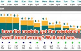
Looks like an active weekend out of the south.
Looks like an active weekend out of the south.
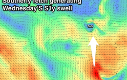
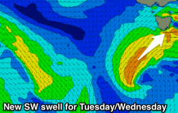
Building SW swell tomorrow but with W-W/SW winds, easing Sunday morning with an offshore wind. Tiny Monday, with some new S'ly swell building Tuesday afternoon, peaking Wednesday.
Western Australia Surf Forecast by Craig Brokensha (issued Friday 25th November)
Sign up to Swellnet’s newsletter and receive updates on when the West Australian Forecaster Notes are looking better as well as the latest news sent directly to your inbox. Upon signup you'll also enter the draw to win a surf trip to P-Pass for you and a mate. It doesn’t get much easier so click HERE to sign up now.
Best Days: South West dawn Saturday, dawn Monday, Wednesday morning
Building mid-period S/SW swell tomorrow, easing through Sunday and clean through the morning. Smaller Monday and Tuesday with OK conditions.
New mid-period swell for tomorrow, peaking Sunday morning with favourable winds for the Surf Coast each morning. Easing surf Monday and Tuesday with more variable winds.
New inconsistent NW groundswell for Friday afternoon, easing through the weekend, with another swell for early next week. Larger swell for next weekend.
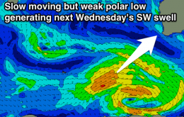
The fetch responsible for our current swell event has largely exited the swell window, so we’re looking at a slow but steady easing trend from Thursday onwards.
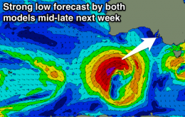
The models have tightened up the strength of the developing Tasman low on Thursday, and aligned it a little closer to the mainland, which has ever-so-slightly upped the size potential for Friday.
Building and strengthening E/SE groundswell tomorrow, peaking overnight and easing Friday with decent winds. Small S'ly swells for Sunday and Monday.
Tiny tomorrow, and Friday morning followed by an afternoon increase in W/SW swell. Better swell filling in Saturday with morning offshores, easing Sunday with W/SW winds. Some fun S/SW swell mid-next week.