Coupla unreal days of waves ahead

Sydney, Hunter and Illawarra Surf Forecast by Ben Matson (issued Monday 5th October)
Best Days: Wed/Thurs: strong E/NE swell, easing Fri though wind affected at times Thurs AM (keep an eye out for a late W/NW change). Some S'ly swell in the mix too. Wednesday the pick of the week.
Recap: Saturday morning saw very small leftover S/SE swell around 1-2ft, before it faded through the day., The afternoon picked up building NE windswells but Sunday offered a more convincing size with bumpy 2-3ft sets under a moderate to fresh N/NE breeze. The surf built further to 3ft+ late afternoon and overnight into this morning, though has eased a little throughout the afternoon. The N/NE breeze has picked up a little through the day so conditions have deteriorated slightly. An approaching S’ly change is currently north of Ulladulla and south of Jervis Bay.

Monday NE swell across the Manly stretch
This week (Oct 6 - 9)
Tonight’s southerly change is expected to stall off the Lower Mid North Coast early Tuesday morning. This will maintain moderate to fresh S’ly winds north from Sydney (and probably Wollongong) early on, though it’ll ease in strength throughout the day. There's only s slim chance of an early SW across one or two locations as well, mainly the Northern Beaches. South from Wollongong, we’ll see lighter winds most of the day.
The change doesn’t have much body behind it so only a minor local windswell is expected on Tuesday, maybe the odd 2ft wind wave at south facing beaches. Our current NE windswell will also be much smaller by Tuesday though there is an underlying E/NE trade swell, which has built nicely throughout SE Qld and Far Northern NSW today and should offer inconsistent 2-3ft sets at open beaches throughout the day.
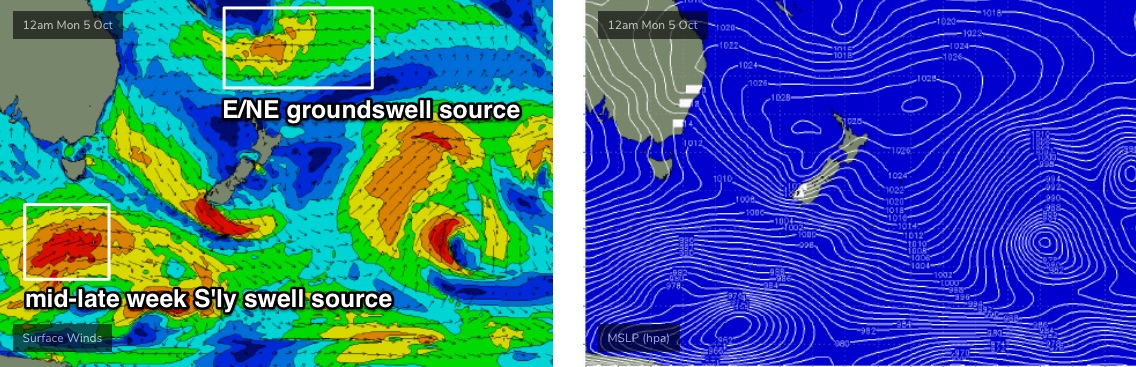
The main feature on the charts right now is an easterly dip in the north-eastern Tasman Sea, midway between New Caledonian and Fijian longitudes (see below). A broad high to the south is squeezing the easterly flow between the two, and it’s been stationary for a few days now so will generate a long-lived pulse of E/NE groundswell that will fill in on Tuesday afternoon (say, rogue 3-4ft sets late in the day) before holding 3-5ft Wednesday morning ahead of a peak late Wednesday through Thursday morning, somewhere between 4ft and 6ft at exposed locations.
Wednesday’s conditions look excellent north from Wollongong, with light variable winds under a weak troughy pattern, though freshening easterly winds are expected on the Far South and potentially South Coasts as an unrelated inland trough begins to develop.
For the record, late Tuesday and Wednesday will also see a small SE swell (originating from a modest ridge in the central Tasman, trailing today’s change) and Wednesday’s local E’ly fetch will also kick up some additional short range energy for southern locations (though they’ll be wind affected).
Thursday’s early peak in E/NE swell looks like it'll be wind affected from a freshening N/NE airstream as the trough muscles up ahead of a very late W/NW wind change. At this stage we’re looking at an arrival from about 3-4pm onwards, so expect blown-out conditions for the most part - including 3ft+ of short range NE windswell on top - but the late session could be very interesting indeed, with the solid swell combo and a brisk offshore ironing out the bumps. I’ll have more on the timing in Wednesday’s notes.
Surf size will then ease steadily from Friday onwards, initially 3-4ft+ of E/NE swell, smaller later, and it’ll be clean with generally offshore winds.
And another byline for the record - Wednesday thru’ Friday will see a small undercurrent of long period S’ly swell, sourced from the parent low to today’s approaching S’ly change (though much further south from Tasmania, see below). The associated swell will be only a distant secondary influence thanks to the more dominant E/NE swell, but south swell magnets should pick up inconsistent 2-3ft sets.
This weekend (Oct 10 - 11)
After an exciting week in the surf department, the weekend’s shaping up to be a little non-descript.
A slack synoptic pattern in the Tasman from Friday onwards is expected to result in no major new swell sources, so we’ll be relying on background, peripheral energy. Most beaches should pick up stray 1-2ft sets and conditions will be clean with light winds, but it’s not looking to be anything special.
Next week (Oct 12 onwards)
A stalled trough in the Tasman Sea over the weekend may become a good catalyst for a new E/NE swell source next week. Too early to pin down specifics right now though.
Elsewhere, and a series of strong fronts are expected to push into the lower Tasman Sea early next week, suggesting mid-week will pick up a decent south swell.
More on this in Wednesday’s update.
Comments
Wed morning locked in
La Niña coming swell pattern?
Got a little taste this afternoon of new swell , frothing for tomorrow.. 2ft turned into 3.5ft on bigger sets..
Yep, great kick late, good lines, 3-4ft sets. Yew.
How windy Thu Am on nth beaches? A write off or a few spots that don’t mind a little NE wind/swell combo worth taking the morning off for?
it was a good day for getting a few on the head while trying to avoid the crowds