Excellent waves ahoy!

Sydney, Hunter and Illawarra Surf Forecast by Ben Matson (issued Friday 6th March)
Best Days: Mon/Tues/Wed: strong SE swell, sizeable Tues, with great conditions Tues/Wed (lingering S'ly winds possible Mon).
Recap: Thursday’s S’ly swell came in a little under budget, with only a few south facing beaches reaching 3-4ft (against a forecast of 3-5ft). Surf size was smaller elsewhere, and conditions weren’t great (as expected) with freshening NE winds, though they concurrently generated some new NE windswell. On the other hand, today delivered great waves through the morning with size coming in a little bigger out of the NE than expected (4ft sets against a forecast of 3ft+), though it has since eased. We’ve seen smaller easing S’ly swells in the water too, and early offshore winds swung S’ly around lunchtime in Sydney (earlier on the South Coast).

Cooking Coal Coast this morning
This weekend (Mar 7 - 8)
Still nothing amazing expected this weekend, thanks mainly to a firm ridge extending along the entire NSW coast behind this afternoon's southerly change.
This pattern will maintain gusty S/SE winds both days, with only an outside chance for isolated pockets of morning SW breezes. A gradual easing of winds is likely into Sunday afternoon though.
As for surf, today’s NE swell will ease right back and we’ll see a building mix of mid-range S’ly swells from a broad fetch trailing today’s change. South facing beaches should manage 3-4ft+ sets at times though these locations will be quite bumpy, and it’ll be much smaller at anywhere not completely exposed to the south. The Hunter region should pick up a few bigger waves near 4-5ft+.
A small E/NE groundswell and a minor E’ly swell (from a fetch exiting western Cook Strait yesterday) will also be in the mix this weekend though it’ll be impossible to detect beneath the local S’ly swell.
Next week (Mar 9 onwards)
There’s been a significant upgrade for the first half of next week.
The trough off the South Coast today is actually the remnants of ex-TC Esther. Although we’ll see an average mix of southerly swells from it over the weekend, the trough is expected to redevelop into an impressive Tasman Low later Saturday, near the SW tip of New Zealand’s South Island (see below). This is a decent upgrade from what Wednesday’s models were estimating.
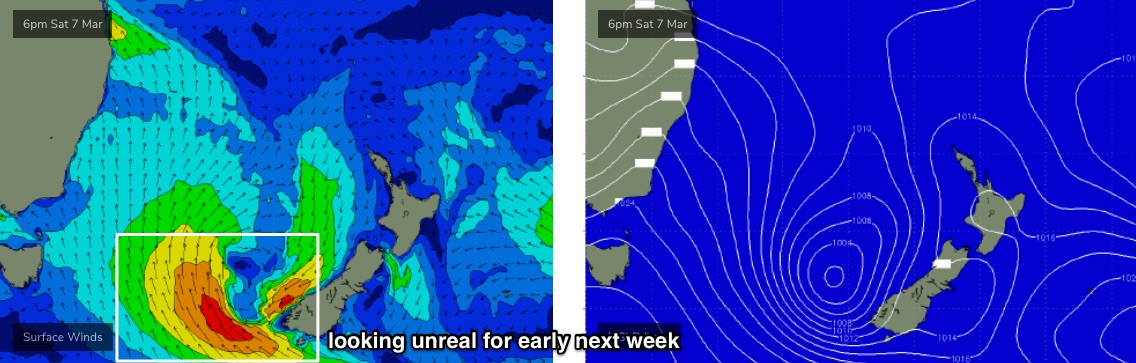
This new cut-off low (are we still allowed to refer to its reincarnation as ex-TC Esther? I don’t know) is expected to reach a peak in intensity on Sunday morning, and then retrograde slowly westwards, back towards Australian longitudes, at strength, holding into Monday before rotating clockwise out of our swell window during Monday and then abating from Tuesday.
All in all, it looks like a fantastic low pressure system in one of my favourite swell windows for Southern NSW.
The resulting SE groundswell will step-ladder upwards incrementally in size. Model guidance is suggesting a temporary easing trend on Monday but I disagree; I think we’ll probably see initial S/SE swells from the redeveloping low, pulsing across the South Coast late Sunday, reaching Sydney overnight and persisting through Monday with solid 4-5ft sets (bigger across the Hunter near 5-6ft). Anywhere not open to the south will be smaller, of course.
The main energy is however expected to reach the South Coast very late Monday - probably too late to work around - pushing into Sydney overnight, and showing best for surfers early Tuesday morning with the direction firmly around to the SE by this time. Most open stretches should push the 5-6ft mark and I wouldn’t be surprised if the longer swell periods draw out nicely across a a bunch of exposed, reliable bombies, with occasional 6-8ft sets (they’ll be the exception rather than the rule though). A steady drop in size is then expected through Wednesday.
Local conditions look to be pretty good though lingering S’ly breezes may spoil the party on Monday. There's a better chance for quite a few locations to see early SW winds, but for the most part we’ll probably see moderate S’lies, so just be cautious with Monday's expectations (though it could be good in parts).
Tuesday and Wednesday on the other hand look excellent with light variable winds (probably early offshore, afternoon onshore).
The rest of the week will see a mix of rapidly easing SE swell and small, steady trade swell from a modest ridge through the Northern Tasman Sea. Small long period S’ly swells will glance the coast next week from distant polar lows but no major size is expected at this stage. Local NE winds may generate some windswell on Friday but nothing great is expected at this early stage.
Long term model runs have a bevy of exciting developments in the Tasman Sea, though they are a long way away and therefore aren’t worth getting too specific about right now.. but it is certainly worth pencilling in this time period as there's a heck of a lot of quality surf potential. It is autumn, after all.
Should you be freeing up the diary? Hell, yes.
Have a great weekend, see you Monday!
Comments
Beautiful.. more waves with some size.. local banks are firing at the moment
Love your work Swellnet
Hi Ben. Any change to your forecast for early this week?
No.
cheers
Loving the nautical / pirate vibe , Ben.
Makes me want to weigh anchor and set sail down the Highway , bound for the golden sands of the South Coast.