Long term outlook shaping up nicely for Southern NSW

Sydney, Hunter and Illawarra Surf Forecast by Ben Matson (issued Monday 27th January)
Best Days: No great days this week. Sunday looks to be the pick of the forecast period with a peaky NE swell and light morning winds. And next week has a whole bevy of swells to look forward to.
Recap: The weekend delivered a fun mix of swells in the 2-3ft range, from the NE, E/NE and E/SE. Light to moderate onshore winds on Saturday went variable into early Sunday, but interestingly, surface conditions appeared (at first) to be slightly worse at many locations, which somewhat defies logic. Anyway, conditions did improve during the day and there’ve certainly been some fun beaches on offer. Today saw surf size dip to 1-2ft - below forecast expectations - and winds have been moderate out of the southern quadrant (SW early, then S’ly and SE) with not a lot of quality options for the last day of the long weekend.
This week (Jan 28 - 31)
There’s nothing special expected in the surf department this week.
A series of strong fronts below the continent over the last few days have produced very good surf for the southern states today (and it'll persist for a few days), but the swell source was poorly aligned for our south swell window so I’m not expecting a great deal of size throughout Southern NSW. We should see stray 2ft+ sets at south swell magnets such as the Hunter but don’t bank on much energy elsewhere.
Keep in mind that there could be two or three days where this intermittent energy may provide surf (i.e. Tues thru’ Thurs), so if you're lucky to dial into a fun period of waves, make the most of it because the surf will ebb and flow as several swell fronts glance the coast.
A redeveloping, stationary N/NE fetch extending from about Sydney latitudes up to the Northern Rivers (and some distance into the Tasman Sea, of course) will generate small NE windswells for Tuesday, possibly up to 2ft+ at NE swell magnets but there won’t be a lot of push in it. This swell will ease into Wednesday thanks to a shallow S’ly change pushing into the Far South Coast on Tuesday afternoon that’ll disrupt the northerly fetch. This change should reach Sydney overnight.
Wednesday looks pretty average with moderate to fresh though rapidly easing S’ly winds across many coasts, with a chance for early SW winds, mainly south from the Illawarra and possibly also on the Northern Beaches. A small S/SE swell trailing Tuesday’s late change will kick up a couple of feet of low quality energy but it’s not worth worrying about.
Thursday then looks to be small (save the tail end of the flukey south swell, mentioned above), with light winds and afternoon sea breezes.
Elsewhere, and a small tropical low that formed over the weekend (deemed a cyclone - 12P - by JTWC, but not RMSC NADI, the official Tropical Cyclone forecasting centre) is weakening well south-east of Samoa. It has a reasonable fetch and is slow moving but the enormous travel distance will erode most of the energy by the time it makes landfall later this week - perhaps some 2ft+ sets on Friday if we’re lucky (the leading edge may arrive late Thursday). Keep your expectations low from this source too.
Otherwise, freshening N/NE from late Thursday through Friday should kick up 2-3ft+ of low to average quality windswell by the afternoon. It'll be smaller earlier.
So it's not a great period of waves by any stretch. But there will be surf if you’re desperate.
This weekend (Feb 1 - 2)
An approaching trough will maintain moderate to fresh NE winds on Saturday and we’ll see a corresponding boost in surf size into the 3-4ft range. At this stage local conditions look to be a little ordinary with the accompanying winds, but over the coming days we’ll try to highlight possible windows of opportunity.
The trough will envelop the coast into Sunday, bringing about a period of lighter winds, and although wave heights are expected to ease, current indications are that early morning could retain a considerable percentage of Saturday’s size.
Therefore, Sunday's currently shaping up to be the pick of the forecast period. Let’s take a closer look on Wednesday.
Next week (Feb 3 onwards)
On Thursday this week, a series of (poorly aligned) fronts traveling below the Tasman Sea and into the south-west Pacific are expected to merge somewhere south of New Zealand. This is expected to strengthen southerly winds and south-easterly extending off the Antarctic ice shelf, within an unusual part of our south-east swell window (see below).
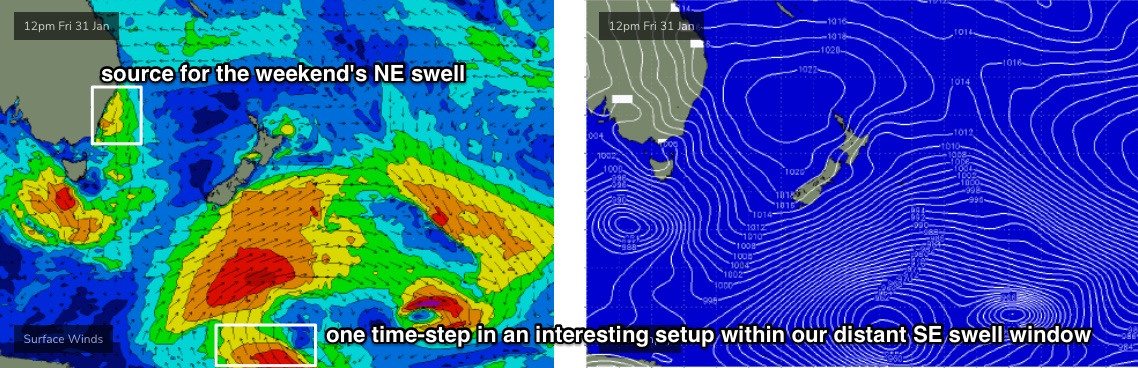
It’s a flukey swell source, and still some time away from developing, but at this stage I’m expecting a fun SE swell too arrive sometime early next week, providing 2-3ft surf across Southern NSW for a day or two.
We have plenty of other swell sources on tap for next week too.
A strong frontal system through the lower Tasman Sea around Mon/Tues looks like it’ll generate some strong southerly swell from Tues/Wed onwards (timing is not clear at this stage) and its troughy remnants may supply punchy, useful E/SE swell through the second half of the week. Again, the specifics are broad at this point in time but the overall trend is very promising. I'm quite fond of these kinds of stalled synoptic setups for swell potential.
I’m also still expecting the tropics to redevelop in the New Caledonia/Fiji region mid-late next week, though the models have cooled since Friday’s notes so the chances for a large swell event from this setup has weakened a bit. It’s still early days though (and there’s still a suggestion for a nice E’ly dip) so let’s reevaluate on Wednesday.
Comments
Was no early onshore in The 'Gong on Saturday morning, was sheet glass for much of it and fun beachies in 2-3ft range at magnets