Ordinary week of waves on the slow boil

Sydney, Hunter and Illawarra Surf Forecast by Ben Matson (issued Monday 9th December)
Best Days: Tues: fun NE swell with good conditions appearing at some point throughout the day.
Recap: Strong southerly swells built across the coast over the weekend, reaching a peak later Saturday with south facing beaches pushing into the 3-5ft range. However, a few reports have filtered through of solid 6ft+ sets at south swell magnets. Size remained healthy into Sunday though generally eased from the 3-4ft range, and we’ve seen a further slight decrease to 3ft this morning. Conditions were OK over the weekend with light variable winds and sea breezes Saturday, though lingering onshore into Sunday morning kept quality below average, and the breeze freshened into the afternoon. Light NE winds this morning will freshen throughout the day, generating a small windswell as the S’ly swell eases.
This week (Dec 10 - 13)
We’ve got a patchy week of waves ahead.
Fortunately, Tuesday’s NE swell has been bumped up a little as the local fetch now looks like it’ll be a little stronger than Friday night’s model guidance indicated.
NE facing beaches should pick up decent 3ft sets, and although the morning will see a lingering northerly flow, winds should become variable for a period ahead of a S’ly change that’s expected to nose into the South Coast late morning, the Illawarra early-mid afternoon and the Sydney region mid-late afternoon.
As such, there should be a period of decent waves on offer - probably not first thing, but very likely around the middle of the day (depending on your region and its timing with the change).
The responsible N/NE fetch will retreat slowly to the north as the S’ly change advances, so we’ll probably see a slow, rather than rapid decline in NE swell into Wednesday morning, with 1-2ft sets leftover at a handful of NE swell magnets.
On the other hand, the trailing southerly fetch looks like it’ll generate a peaky local S’ly swell for Wednesday in the 3ft range for south facing beaches (with a few bigger sets across the Hunter).
Unfortunately, the southerly breeze will persist against the coast into the morning (mainly north from Wollongong), maintaining below average conditions at south facing beaches. One or two regions may see locally influenced SW winds for a period around dawn, but in general this will be the exception rather than the rule and conditions really won’t be terribly inspiring.
Wednesday’s S’ly swell will ease steadily into Thursday, but a small SE fetch beneath the trough (associated with the southerly change) will maintain peaky 2ft waves at most open beaches. Local winds should ease back and remain light and variable for most of the morning, but a strengthening ridge across the coast will freshen S/SE winds into the afternoon. On the balance, keep your expectations low.
These onshore winds are modeled to weaken across the coast into Friday morning, and won’t be strong enough to generate any new swell. However, a front exiting eastern Bass Strait on Thursday afternoon is likely to generate a small acute southerly swell for Friday with 2ft+ sets at beaches with good southerly exposure (a little bigger through the Hunter). Expect smaller surf elsewhere thanks to the swell direction.
This weekend (Dec 14 - 15)
Friday’s southerly swell source from eastern Bass Strait is expected to marginally strengthen over the weekend, though tilt slightly less favourably away from our swell window.
So, we need to split the difference - the stronger, more sustained winds are theoretically capable of a little more size, but the poor alignment will reduce the number of beaches that pick up any swell.
Frontal systems further south on Thursday are likely to offer some small secondary swell for south facing beaches too.
For now I’m going to hold steady with slow, inconsistent 2ft+ sets at south facing beaches, but this will need to be revised in Wednesday’s update. Elsewhere, expect very little surf. It’s certainly not looking like being a terribly active weekend in the surf department.
Next week (Dec 16 onwards)
The long term outlook suggests a steady progression of average cold fronts migrating from the Southern Ocean into the Lower Tasman Sea, though the general storm track doesn’t look conducive for any major size.
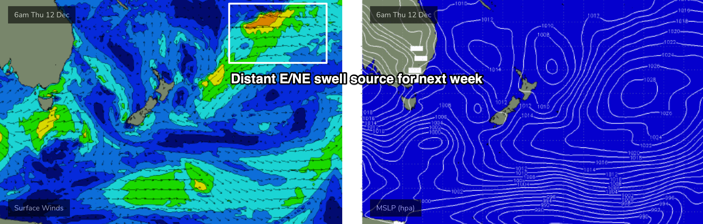
Elsewhere, and there’s no suggestion for any major activity in the Tasman Sea or Coral Sea. However, there is some interesting model output further afield, with a broad, complex low pressure trough likely to develop north-east from New Zealand later this week (see below), in our far E/NE swell window, and this may offer some fun background E/NE swell for next week. Nothing worth worrying about for now though.
See you Wednesday!
Comments
Well the smoke has finally impacted me, it's so bad today, slight headache, irritated throat, sick stomach. Yuck!