Not a particularly inspiring period to consider looking for surfable action

Sydney, Hunter and Illawarra Surf Forecast by Ben Matson (issued Friday 22nd November)
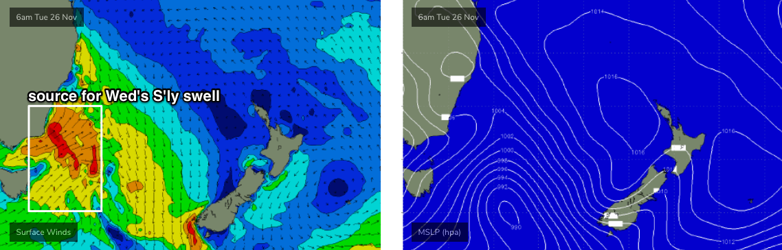
Best Days: Wed AM: brief S'ly swell with early light winds, size easing rapidly.
Recap: Persistent S’ly swell maintained 2ft+ surf across south facing beaches on Thursday, as light northerly winds freshened from the NE throughout the day. This built NE swells that reached a peak around 3ft this morning, as southerly winds pushed across the coast, reaching the Northern Beaches around 7am. Surf size has slowly eased from the NE during the day though we’ve seen a small increase in S’ly windswell.
This weekend (Nov 18 - 19)
The local fetch responsible for today’s NE swell has weakened today, and retreated to a position off the Mid North Coast.
Being smaller in size, with less strength, and slightly further aligned outside of our swell window, its swell potential has been weakened considerably though a handful of NE swell magnets should see 1ft, maybe 1-2ft waves through Saturday before easing back to a foot or less on Sunday. Today’s small S’ly swell will ease back overnight so I’m not expecting any action from this quadrant over the weekend.
Saturday’s winds are looking reasonable, mainly variable under a weak troughy pattern though periods of light to moderate onshores can’t be ruled out.
The trough is expected to briefly form a closed low well offshore overnight Saturday, and may briefly develop moderate to fresh S/SE winds adjacent some coasts early Sunday morning, before easing back again during the day. We may see a small local windswell as a result (say, slow, peaky 2ft sets at south facing beaches) but it’s really not worth worrying about.
Next week (Nov 20 onwards)
The storm track is all out of whack for our swell window right now.
Southern Ocean fronts are poorly aligned, there’s not a lot of activity happening in our tropical swell window (though we may see an early season TC north-east of Vanuatu next week), and generally troughiness along the coast will generate small local swells but nothing of any great substance.
There's actually a nice sub-tropical low developing NE of New Zealand right now, but not only is it located inside the general swell shadow for Southern NSW, the fetch is aimed up towards Fiji. So, nada.
The best of the period looks to be a small building NE swell on Tuesday (2ft+ arvo sets) ahead of a late S’ly change that’ll deliver a brief, punchy S’ly swell for south facing beaches - probably peaking under the cover of darkness overnight Tuesday with 4ft sets, and therefore easing rapidly from first light Wednesday. Winds should however be light so conditions will be clean for the early session. Pencil that into your diary as it'll probably be the only day worth getting wet next week.
Looking beyond this and we’ve got more small intermittent southerly swell pulses for the second half of the week and next weekend (nothing to get excited about) and a bunch of small NE windswell days.
All pretty forgettable stuff, to be honest.
As mentioned above, we may also see a TC near Vanuatu next week - early indications suggest it’ll remain inside the swell shadow, but it’s early days.
Have a great weekend! See you Monday.