Coupla fun small pulses of south swell on the way

Sydney, Hunter and Illawarra Surf Forecast by Ben Matson (issued Monday 18th November)
Best Days: Most days should have brief windows of small surf at south swell magnets, though you'll have to work around the winds. Late Wed/early Thurs, and Fri will see the most size, the latter should also have a fun NE swell in the mix too.
Recap: The weekend delivered small pulse southerly swells, reaching up to 2-3ft across Sydney’s south facing beaches and 3-4ft across the Hunter from Saturday afternoon thru’ Sunday, even holding into this morning. Saturday morning saw lingering onshore winds, though they eased throughout the day, whilst Sunday cleaned up with light variable winds ahead of another gusty S’ly change during the afternoon. This morning provided clean conditions again with light winds returning across the coast, though NE sea breezes are now up.
This week (Nov 19 - 22)
At first glance, it looks like a pretty dismal week of waves ahead.
But, there are small windows of opportunity and it’ll be worth keeping a flexible schedule. The models are not really picking up many of the minor inbound swells and we’ll probably see some reasonable small waves at exposed spots.
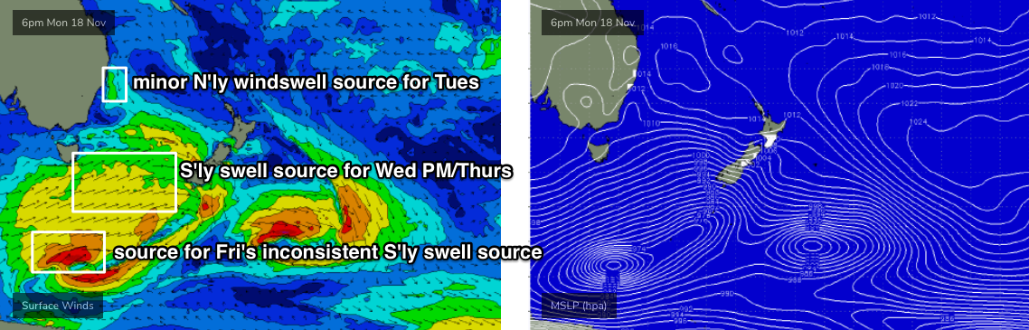
First up - general troughiness will linger across the coast for the next few days. Light winds are expected Tuesday morning, ahead of a southerly change that’ll push up the South Coast during the day. It’s not expected to reach Wollongong until very late afternoon or early evening, so locations to the north will probably see freshening NE sea breezes from about lunchtime onwards.
Surf size will remain small out of the south on Tuesday, with today’s energy easing back into the morning, ahead of a small renewal of swell originating from a front that passed under Tasmania over the weekend. No major size is likely, and the swell will be flukey and erratic (i.e.not favouring all south facing beaches). As a baseline, let’s peg morning wave heights around 1-2ft at south facing beaches, building to a very inconsistent 2-3ft mid-late afternoon, slightly bigger through the Hunter but much smaller elsewhere. We may also see some small NE windswell across exposed beaches in the morning.
Wednesday will see a return to variable winds as the S’ly change dissipates overnight Tuesday and we see troughiness dominate the region again. Afternoon sea breezes are likely, and there’s another afternoon pulse of small S’ly swell on the cards from frontal activity south of Tasmania - so I’m going to anticipate another brief morning easing trend (from Tuesday’s pulse) with south facing beaches holding 2ft (smaller elsewhere, bigger in the Hunter) before it rebuilds to an inconsistent 3ft in the afternoon. The Hunter should be another foot or so bigger.
Wednesday afternoon’s pulse will slowly ease throughout Thursday but the morning should hold a similar size to begin with. Winds should be favourable early morning under a light NW breeze but we’ll see strengthening northerlies into the afternoon as a Tasman high ridges up against the coast (so aim for a morning paddle). They’ll generate some local windswell for Friday morning, probably in the 2-3ft+ range, easing during the day.
Friday will also see the arrival of yet another small pulse of S’ly swell. The energy arriving Wednesday afternoon/holding early Thursday will have been generated by a broad (though poorly aligned) front south of Tasmania on Tuesday (see below), of which its parent low well to the south is expected to stall and then briefly slingshot through our far southern swells window (see below).
There’s a considerably larger travel distance for this energy (compared to the southerly swells prior this week) but the periods should draw out a little longer and south facing beaches should pick up some 2-3ft sets, pushing 3-4ft across the Hunter - though it’ll be much less consistent than any other day this week.
However, add this in with the pre-existing NE windswell and a light variable wind pattern under a resumption of locally troughy synoptics, and exposed beaches should have some super fun peaky waves to finish the working week.
This weekend (Nov 18 - 19)
The weekend looks pretty average at this stage.
Friday’s swell sources will be all but gone, with slow 1-2ft NE swell at exposed beaches in the morning, plus lingering S’ly around 1-2ft, easing during the day.
There is one system to keep an eye on in the updated forecasts this week - an intense low passing south of Tasmania around Thursday. Despite core wind speeds of 50kts+, it looks even less favourably aligned than anything else developing this week, so confidence is pretty low we’ll see any energy glance the NSW coast.
But, it can’t be ruled out - so I’ll put an asterisk down for late Saturday and Sunday, and revise this in Wednesday’s notes.
Local winds look generally light, perhaps S’ly on Saturday in the lee of the trough but otherwise nothing substantial.
Next week (Nov 20 onwards)
Nothing of interest showing on the long term outlook at this stage.
Comments
Smoke or fog?
Smoke! Never been irritated by it until today. Sore throat and everything after surfing.