Fun weekend of southerly swell ahead

Sydney, Hunter and Illawarra Surf Forecast by Ben Matson (issued Wednesday 6th November)
Best Days: Fri: keep an eye out for a low percentage, small S'ly swell at a handful of south swell magnets. Sat/Sun: fun building S'ly swell (peaking late Sun) with morning offshores. Mon: strong S'ly swell, light offshore winds. Thurs/Fri: more S'ly swell potential.
Recap: Gusty southerly winds kicked in on Tuesday morning and built poor quality S’ly swells through the day. This morning offered a brief window of fun small waves at south facing beaches around 2ft+, but it’s eased through the day. Conditions were clean with light north-west winds but the NE sea breeze is now up across the coast.

Small leftovers at Avoca this morning
This week (Nov 7 - 8)
Thursday will be very small.
Today’s S’ly swell will be all but gone, and a minor NE windswell from a developing N’ly fetch overnight doesn’t look like it’ll manage much more than a stray one foot wave at the swell magnets. Conditions should remain clean with early offshore winds ahead of an afternoon sea breeze.
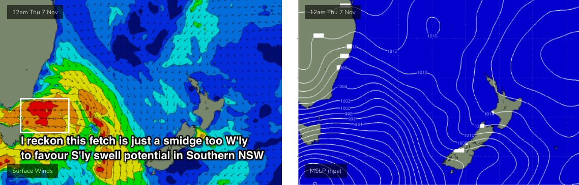
A vigorous cold front will cross the Tasmanian divide during the day, and westerly gales will develop across eastern Bass Strait and the lower Tasman Sea.
The models are split on swell potential for this. On the one hand, the fetch exiting eastern Bass Strait is expected to be straight W’ly, almost W/NW at times (see chart below), which should ordinarily rule out any northward spread (almost 180 degrees worth) back into the Southern NSW coast.
However, the fetch is very strong and sustained and in the absence of any other energy, the swell models are showing a small southerly event pushing up the coast overnight Thursday, for a Friday morning pulse across our region.
I’m inclined to keep my expectations very low from this source, as there are more factors pointing towards a non-event than those suggesting anything worthwhile.
But, given local winds will be generally favourable (probably NW through the morning, maybe a brief early a’noon NE sea breeze but then a late W/SW change), it’s worth keeping an eye on south swell magnets for a few stray 1-2ft sets throughout the morning. You’ll have a better chance of this north from Sydney into the Hunter region than anywhere south from Sydney though.
If you have to hedge your bets and make a decision right now, give it a miss.
This weekend (Nov 9 - 10)
An amplifying Long Wave Trough across the Tasman Sea this weekend will drive a number of cold fronts through our broader south swell window. As mentioned on Monday, the storm track will be titled more SW/NE which will reduce the spread of maximum surf size to a handful of reliable south swell magnets.
This pattern will provide fluctuating southerly swells through Saturday, probably reaching a weekend peak on Sunday afternoon ahead of a larger, final pulse early next week.
Winds look pretty good for the most part, generally from the W/SW thru’ SW in the mornings, tending S/SW to S/SE into the afternoons - but without a great deal of strength.
At this stage I’ll peg surf size around 3ft+ across south facing beaches on Saturday, building a little more into Sunday around 3-4ft+. We should be able to whack another foot, maybe two feet on top of this across the Hunter region.
However as per usual, any beach not open to the south will be much smaller due to the acute swell direction. On Friday I’ll be able to firm up the arrival times of each peak and their likely size a little more precisely.
Next week (Nov 11 onwards)
The strongest front in the weekend sequence will track into the lower Tasman Sea on Sunday night, providing solid waves for Monday. South facing beaches should see solid sets in the 3-5ft range and the Hunter (and other reliable south swell magnets) should be closer to 5-6ft at times. The usual south swell caveats will apply elsewhere.
Conditions are looking really good thanks to the fronts pushing offshore into the Tasman Sea, resulting in light offshore winds and afternoon sea breezes. So, it's worth booking in a surf on Monday.
Looking further ahead and a broad, deep low is expected to form south of Tasmania early in the week and extend a S’ly change along the coast on Wednesday. Prior to this, strengthening N’ly winds will generate a peaky NE swell on Tuesday.
Wednesday’s southerly wind change looks pretty bog standard at this stage, but I’m more interested in the southerly groundswell potential from the associated Southern Ocean activity. It’s too early to pin down specifics, but Thursday and Friday are looking quite promising for some decent southerly swell at this stage.
Let’s take a closer look on Friday.
Comments
I'll book in Monday morning 730 Thanks
pheww thought we had seen the last of the south swells
South swells in late Spring, again.
Spring is the new Autumn...