Building energy from the north-east

Sydney, Hunter and Illawarra Surf Forecast by Ben Matson (issued Wednesday 30th October)
Best Days: Entire period: building NE swells, biggest over the weekend but with tricky winds.
Recap: S’ly swells maintained 2-3ft surf at most south facing beaches on Tuesday with occasional 3-4ft sets at south swell magnets. The south swell eased back a fraction overnight, and is now mainly 2-3ft at exposed spots, and we’re seeing a similarly sized NE windswell in the water too. Winds have been light through the mornings with freshening afternoon sea breezes.
This week (Oct 31 - Nov 1)
The Southern Ocean is still directing southerly energy through the Tasman Sea but it’s all a little more off-axis than the swells that provided fun waves for the first half of this week. There’s still a few minor swell fronts expected to glance the coast but in general the rest of the week will probably see smaller, very inconsistent wave heights at south facing beaches, in the 2ft range tops. If we’re very lucky, reliable south swell magnets (such as the Hunter) may see a few bigger waves but I wouldn’t bank on much happening from this direction.
Anyway, NE windswells will become the dominant swell train over the coming days.
A double centred high-pressure system in the Tasman Sea is maintaining a stationary fetch in our near swell window (responsible for today’s waves) and it’ll persist into Thursday with slow but fun waves of a similar size, though expect periods of slower surf - it’s not a particularly strong fetch and coverage will be a little patchy. Early winds should be light as they were this morning but we’ll see freshening NE breezes into the afternoon.
The two Tasman highs will consolidate into Friday and strengthen, and as a result N/NE winds will become fresh and gusty through the day, also building NE windswells into the 3-4ft range by late afternoon, though it’ll be smaller earlier. There’s less of a chance for an early window of light winds, so expect average surface conditions in general, especially into the afternoon as the breeze picks up in strength.
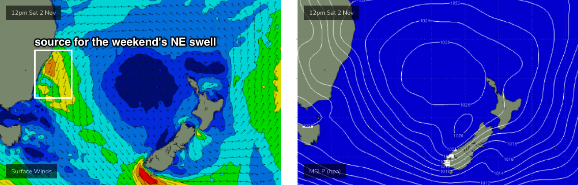
This weekend (Nov 2 - 3)
The models have doubled down on any troughy incursions over the weekend, limiting their reach to the Far South Coast at best, and perhaps just on Sunday afternoon (and, even that may not eventuate).
Therefore, the weekend surf outlook is a little more straight forward, thanks to the stationary N/NE fetch remaining at strength for at least the first half of the weekend.
NE facing beaches will see peaky surf anywhere between 3ft and 5ft both days, but local winds will remain from the same quadrant so only sheltered northern corners will be clean - and they’ll be smaller.
Hopefully the advancing trough will allow local winds to moderate a little on Sunday afternoon but at this stage it’s looking like an average though solid weekend of waves.
Next week (Nov 4 onwards)
The trough will push more definitively into the Tasman Sea by Monday though no major strength is expected on its western flank (i.e. from the south). We’ll see building S’ly windswells to 2-3ft+ through the day at south facing beaches. but quality will diminish as the wind picks up (early morning may have a window of light winds, but there won’t be much size at this time). The weekend's NE swell will be rapidly abating by this time too, though early on should see a few leftover sets.
The models have a loose consensus that a weak low may form off the coast during Monday but they then scoot it away to the NE, so I’m not expecting much surf from this system.
Otherwise, a series of poorly aligned fronts will then track south of Tasmania, supplying southerly swell for the rest of the week. The first fronts look rather unimpressive but a strong system later Tuesday is on track to provide some interesting long period though very directional south swell around Thursday. Let's ballpark south facing beaches in the 4ft+ range at this stage.
More on this in Friday’s update.
Comments
Anyway, NE windswells will become the dominant swell train over the coming days.
Your faith in North East wind swells I always find quaint, Ben.
Perhaps it's a QLD thing. Tends to mean nothing but slop around here.
I suppose it's a dietary thing. Ends up being a summer staple and for many spots it's the preferred direction.