Plenty of great waves ahead, just gotta pick your days

Sydney, Hunter and Illawarra Surf Forecast by Ben Matson (issued Friday 13th September)
Best Days: Sun: decent S'ly swell with offshore winds. Wed/Thurs: fun E'ly swell with generally good winds. Thurs/Fri: interesting long period S'ly groundswell.
Recap: Thursday morning delivered fantastic surf with light offshore winds and 3-5ft waves at most open beaches, with size easing through the day, and winds were light and variable in general. Unfortunately, a long period southerly swell forecast to push through the afternoon appears to have not materialised, with the wave buoys not picking up any long period energy (though, the Tweed buoy near the NSW/Qld border detected leading edge swell periods of 22 seconds from this swell this morning). As such, we’ve seen very small surf today, with unexpectedly bumpy conditions through the morning as a cold front - not apparent in the data when Wednesday’s notes were produced - clipped the coast. Average wind speeds were back under 10kts by 10am, but with only small waves on offer there’s not much to get excited about this afternoon.
This weekend (Sep 14 - 15)
We’ve got a couple of south swells in store for the weekend, generated by transient fronts through the lower Tasman Sea. The second one is the biggest and best (see below) and will generate the best waves of the weekend on Sunday.
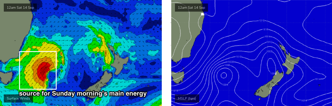
The general trend is up through Saturday to 2-3ft+ at south facing beaches by the afternoon, easing from an overnight peak through Sunday - perhaps some 3-4ft sets early morning - and with generally favourable conditions. Though, Saturday is at risk of a moderate southerly breeze clipping the coast during the morning, creating bumpy conditions at exposed south facing beaches (they’ll also see the most size from the south swell).
We should see larger surf across the Hunter too; early Sunday morning could be pushing 4-5ft, maybe even 4-6ft at times though it’ll also trend down through the day. However, anywhere not directly open to the south will be a lot smaller.
Sunday morning is the pick of the weekend as we’ll be around to a light morning NW breeze and conditions will be clean just about everywhere.
Next week (Sep 16 onwards)
Next week just got a whole lot more complex.
In a addition to a series of interesting long period southerly swells glancing the coast, a small trough will push up the Southern NSW region on Monday (early NW winds swinging S’ly during the afternoon), before stalling off the Mid North Coast, and then broadening a nice E’ly fetch through the central Tasman Sea for a few days.
Monday looks pretty small at this stage, with easing leftovers from Sunday (2ft south swell magnets, maybe just the Hunter, smaller elsewhere) becoming tiny by lunch. The models have a late arrival of long period S’ly swell but winds will be onshore by this time so it’s not worth worrying about.
Tuesday looks pretty average with peaky, bumpy short range S’ly swell in the lee of the change, plus an accompanying southerly breeze (maybe an early sou’wester) but Wednesday and maybe Thursday are where the real E’ly swell potential is, with sets pushing 3-4ft+ at most exposed beaches. Current expectations are for generally light winds as the trough draws away from the coast, but I’ll have a better understanding of local conditions by Monday.
An approaching front from the west will strengthen northerly winds into Friday as the E’ly swell dissipates - we may should some local NE windswell across the region to finish the working week in the 3ft+ range - ahead of a return to southerly swell patterns for next weekend and beyond.
Just a quick note on the long period S’ly groundswells due next week too - in the absence of any major swell systems (and favourable winds) for next week it’d be worth analysing the potential for these groundswells in fine detail. However, the fact is that it’ll generally be hard to spot ‘em underneath the local energy, so there’s not a lot of point spending much time deliberating about remote, flukey swell sources that - like yesterday afternoon showed - may very well not appear as expected.
There is one groundswell I really like the look of though, due in around Thurs/Fri, with leading edge swell periods of 21-22+ seconds that could light up south swell magnets with solid though very inconsistent 3-5ft sets. This will be sourced from a deep low and vigorous front SW of Tasmania around Tuesday, so let’s wait and see how the models resolve things over the weekend.
See you Monday!
Comments
Queensie/North Steyne picking up plenty of size from this new south swell (very surprised Cronulla isn't though).

Was out at a south facing spot and you could tell the swell definitely had a decent amount of east in it, good energy too
Sneaky Easty/Northy?!?!
That easterly fetch and lil' low sure are firming up for tomorrow and Wednesday....
