Southerly regularity

Sydney, Hunter and Illawarra Surf Forecast by Ben Matson (issued Wednesday 15th May)
Best Days: Strong S'ly swell filling in later Thurs, peaking Fri, easing Sat. Another decent S'ly swell Mon arvo and Tues. Light winds and clean conditions in general.
Recap: We’ve seen plenty of S’ly swell over the last two days, generally around 2-3ft at south facing beaches though bigger in the Hunter (smaller elsewhere) and clean with light winds.
This week (May 16 - 17)
Today’s Forecaster Notes are brought to you by Rip Curl
The rest of the week will continue to see favourably light winds and weak sea breezes under a weak synoptic pattern.
As for surf, the current southerly regime will persist for some time. In fact, the models have slightly nudged up the strength of our late Thursday/Friday pulse, so I’m going to whack a plus on Monday’s estimate as I think we’ll see a few bigger waves.
Thursday is likely to start off smaller and very lully with inconsistent swell of a similar size to today; occasional 2-3ft sets at south facing beaches, smaller elsewhere but bigger across the Hunter.
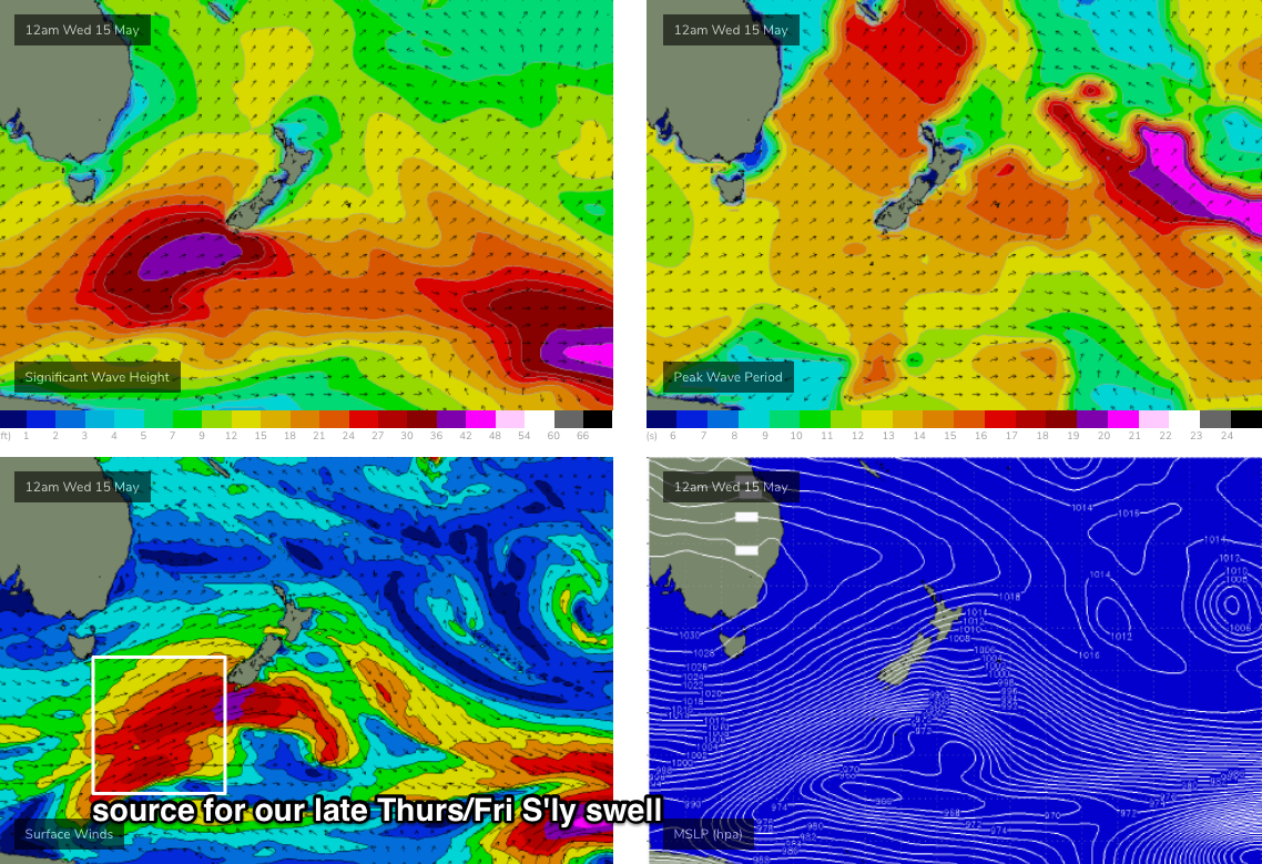
Late afternoon (in Sydney, earlier across the South Coast) will herald the arrival largest southerly swell of this recent sequence, generated by an intense front and low tracking up towards New Zealand today (see chart below). It’s poorly aligned, but there’s a broad fetch of 40-50kt winds working on a very active sea state generated by the fetch that whipped up the last few days of southerly swell, so we’ll see a healthy spread of energy along the East Coast.
Whilst bigger waves are expected to appear late Thursday, Friday will see most of the action, around 3-4ft+ at south facing beaches in Sydney, pushing 4-6ft across the Hunter region and other select south swell magnets and offshore bombies. However, it’ll be a flukey event (being sourced from an off-axis fetch) so mileage may vary across some coasts, especially those further south that will require the energy to spread a few extra degrees.
Of course, beaches not directly open to the south will be much smaller. Regardless, we’re looking at some some really nice clean waves to finish the week so it’ll be worth keeping your diary flexible.
As a side note there’ll be a small undercurrent of E’ly swell in the mix on Friday though it’ll be hard to detect beneath the S’ly swell. This was generated by strong storm activity way out in the South Pacific late last week and over the weekend.
This weekend (May 18 - 19)
The computer models have slowed and weakened the effects of an approaching cut off low in the Bight for the weekend. This means we’ll see light variable winds both days, and fantastic surf conditions.
Friday’s strong southerly swell will ease slowly throughout Saturday, from 2-3ft at dawn at south facing beaches to 1-2ft by late afternoon (bigger in the Hunter, smaller at beaches with less southerly exposure), and we’ll also see a decrease in the consistency of the sets too.
On Sunday, a small reinforcing southerly groundswell will push along the coast, generated by a poorly aligned cut-off low tracking south of Tasmania late Thursday and early Friday. It looks good in single synoptic snapshots, but unfortunately it’s travelling too fast through our swell window, and the fetch doesn’t consolidate well enough to generate any meaningful energy.
As such, we’re looking at residual background S’ly swell on Sunday around 1-2ft at south facing beaches (same caveats, bigger Hunter, smaller elsewhere etc) but we may see occasional bigger sets - say, 2-3ft south facing beaches in Sydney - pushing through every so often. Don’t expect a lot of consistency though, as this energy will only just be glancing the swell magnets.
Also, there’ll be a small undercurrent of E’ly swell all weekend, around 1-2ft at most open beaches. So, combined with the southerly swell we should see some nice peaky waves on offer.
Next week (May 20 onwards)
We’ve seen a change in the long range model guidance, with another strong front expected to approach southern New Zealand over the weekend, offering a similar synoptic setup to the system currently in the region.
This is expected to generate another long period S’ly groundswell for Monday afternoon and Tuesday, offering a wide variety of wave heights across the region due to the acute angle, but possibly up to 3ft+ at south facing beaches with bigger surf across the Hunter.
Let’s take a closer look on Friday.
Comments
yewwww
First light this morning it was consistent 6ft down south. Is it likely this swell came from the earlier SSW swell train, or maybe the new S swell arriving early?
Sounds like the new swell arriving early (was meant to be into Sydney this arvo, holding tomorrow).
Will need to watch the buoys to assess the trend - perhaps the whole event is running way ahead of schedule.
The Northern Beaches were a strong though kinda inconsistent 4ft this morning but on surfing mid-late morning it had eased a little and gone back more to 3ft+. Not the strong lines I saw early morning. Interesting.
Yeah it definitely lost some punch by the time I got out. I just assumed the tide was getting into it. Hopefully more of the same tomorrow.