Complex though extended run of E/NE swell, plus a few punchy south swells

Sydney, Hunter and Illawarra Surf Forecast by Ben Matson (issued Friday 8th February)
Best Days: Fun E/NE swell early Sat then easing; peaky S'ly swell late Sun, then building E/NE groundswell next week, best Tues as S'ly winds will create problems Wed. Later next week and beyond has plenty of strong S'ly and E/NE swell potential.
Recap: Wednesday’s SE swell held into Thursday with early 2-3ft sets easing slowly throughout the day, plus some small E/NE swell in the mix. Today has seen the E/NE swell bump up a little more - with the inclusion of some NE windswell - offering 2-3ft sets at north-east facing beaches. Winds have been generally light in the mornings with afternoon NE sea breezes.
This weekend (Feb 9 - 10)
Today’s Forecaster Notes are brought to you by Rip Curl
Today’s slow E/NE swell should hold into Saturday morning, offering inconsistent 2-3ft sets at beaches with good NE exposure. A small decrease in size may occur throughout the day.
A gusty southerly change will approach the South Coast during the day, but winds across Sydney, Hunter and Illawarra coasts should remain generally light and variable for the most part - possibly light N’ly at times, but probably swinging NW for a period through the morning. If anything, a shallow NE sea breeze may develop mid-late afternoon ahead of the change which is due into the Illawarra region around dinnertime, and Sydney shortly thereafter.
The southerly change will bring about windy conditions overnight, but it’ll clear to the east on Sunday so conditions should improve throughout the morning, and variable winds are likely into the afternoon.
We’ll see the E/NE swell ease back from Saturday but a fresh short range S’ly swell will fill into the coast (originating from the fetch trailing the change), offering an early peak around 3-4ft at south facing beaches (much smaller elsewhere) before easing into the afternoon. Expect lumpy/bumpy conditions (especially north of Sydney through the Hunter) but workable options elsewhere.
Therefore, Saturday morning and Sunday afternoon look to be the pick of the coast this weekend.
Next week (Feb 11 onwards)
The South Pacific synoptics are very tricky.
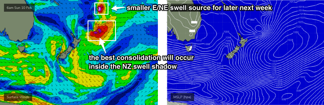
We’ve got a complex scenario unfolding north from New Zealand, though I’m not quite as confident on the consolidation of several tropical lows (and maybe tropical cyclones) within our swell window.
To be clear: they’re going to consolidate very well at some point, and New Zealand is gonna cop a hiding as a series of large NE and E’ly swells make landfall. However, the best consolidation is now more likely to occur once it slips into New Zealand’s swell shadow (see chart beleow), which reduces our surf potential considerably.
As such, we’re looking at an extended run of small to moderate E/NE swell as each system moves south through the swell window. The first swell will probably be the best, originating from the southern flank of an existing trough just north of NZ, which is almost stationary. Wind speeds are not overly strong, but the fetch is broad and long, and we should see 3-5ft surf arrive from this later Monday, building Tuesday and then easing from Wednesday. Set waves will be very inconsistent but they’ll be straight and well defined when they do come through.
Prior to this, expect smaller residual swell to kick things off on Monday morning, with early light winds tending NE and freshening into the afternoon.
Tuesday’s peak in size will be accompanied in a swing in the wind direction to the NW as a trough pushes off the coast, and is therefore your best day to coordinate a paddle. We should also see some small NE windswell in the water too.
Further pulses of long range E/NE swell are expected through the end of the week - from smaller though more intense tropical systems feeding down the NZ trough line - though they’ll be much less consistent and smaller in size by the time they reach the NSW coast, generally around the 2-3ft mark with extremely long breaks between the sets.
Wednesday onwards looks pretty tricky from other sources.
An intense cut off low will strengthen immediately south of Tasmania around Tuesday, poorly aligned for our region but with surface winds likely to be north of 6-kts at the core of the low, we’ll see small long period energy brush Southern NSW, in addition to mid-range S’ly swell from gale force SW winds exiting eastern Bass Strait.
Initially, a strong S’ly change overnight Tuesday will leave local conditions a bit of a mess Wednesday, but there’ll be some trailing windswell in the water before the first south swell fills in during the afternoon, and the longer period energy arrives around Thursday.
It’s a little hard to pick size high now but most south facing beaches should see 3-4ft sets and a few reliable offshore bombies could go a foot or two higher (on Thursday) if the long period energy focuses in well.
We’ll then see a small trough in the central Tasman Sea generate small SE swells later next week, ahead of a renewal of E/NE groundswell from the same broad scale monsoon pattern that’s generating the energy expected next week.
However, the difference this time around is that these systems are much more likely to move westward through the north-eastern Tasman Sea, and have a greater chance at delivering larger, stronger and more sustained E/NE groundswells for the entire East Coast - from about Friday next week onwards, but with the potential for really juicy surf through the early middle part of the following week.
More on this in Monday’s forecast. Have a great weekend!
Comments
Looks fun between the flags at Maroubra!

Pretty spot on with the forecast notes today! About 3pm wind went west and it started pulsing 3ft + as tide dropped to produce some nice booger waves on northern beaches,fingers crossed for tomorrow and next few days!
Unreal mate!
Yep, spot on. Only time I had was yesterday was later in the arvo, was checking it about 2.45 pm and it didn't look flash, the wind swung before 3pm to straight offshore and it cleaned up straight away and it was peaks everywhere.
Great waves everywhere today.
With an SLSC carnival on at Maroubra, the clubbies have their work cut for 'em out today. Surf looks unreal!

Was pumping indeed but with the surf comp nrth, the carnaval, the nippers and the flags area good luck finding a peak where they will allow surfing
Yep, quite the clusterfuck at the 'bra yesterday. Surprised there wasn't a travelling circus as well.
This mythical kick in east swel always seems to be around 7-8 days out on our forecast graph. Been doing that for over a week now! Can’t complain was pumping this morning
Hey Ben, your models have forgotten about your East Swell for Tuesday. Can you address this in your notes for Today. ie: do you still think we are going to ENE Swell Tuesday in the 11 Second plus range?
Just doing the notes now. Yeah, it's a little odd.