Average surf to finish the week; long period S'ly swell Sunday and Monday

Sydney, Hunter and Illawarra Surf Forecast by Ben Matson (issued Wednesday 23rd August)
Best Days: Fri/Sat: short range S'ly swell with brief windows of OK winds. Sun: building long period S'ly groundswell plus mid range SE swell spread, OK winds early. Mon: long period S'ly groundswell and SE swell spread, light winds. Tues: mix of easing S'ly swells with peaky E/NE swell.
Recap: Clean 3ft+ leftover S/SE swelling light offshore winds provided very nice waves across Southern NSW on Tuesday, and although the trend has eased into today, we’ve seen a little more size and energy than expected from the tail end of the weekend’s large, sustained swell event. South facing beaches are still in the 2-3ft range and with the swell direction SE, there are plenty of open beaches picking up fun clean waves under a light variable breeze.
This week (August 24th - 25th)
A developing southerly change on Thursday morning will wipe out surf conditions across exposed beaches. Early morning should see a period of SW winds but once they swing S’ly it’l become very choppy.
Initially, we’re only looking at small residual energy from today (smaller than what’s on offer right now) padding out the exposed beaches. However strong southerly winds in the wake of the change should generate 3ft+ of short range southerly windswell after lunch at south swell magnets, possibly a few bigger sets right on dark. Quality will be low though.
On Friday, this change will clear to the east, forming a small Tasman Low well east of Sydney, aimed poorly in our swell window (to the north). As such, wave heights will peak early and then ease slowly throughout the day; south facing beaches may see morning 3-4ft sets but it’ll become smaller after lunch.
There’s now an increased risk of lingering southerly winds across many coasts throughout the day too. It should ease as the day progresses, and a handful of locations such as the Northern Beaches) will likely to see local topographical influences swing the wind to the SW in the morning, but in general conditions will be wobbly at open beaches.
This weekend (August 26th - 27th)
This Tasman Low will remain slow moving all weekend, but unfortunately it’ll be positioned just north of our swell window. As such we’re looking at only small SE swells spreading back into Southern NSW from this source. A weak front entering the Lower Tasman Sea on Saturday may also contribute small levels of southerly swell into Sunday.
The biggest waves on Saturday will be found between the Sydney and Hunter coasts, with sets around 2-3ft+. South of here, wave heights will drop off, and we’ll also see smaller surf at beaches with less southerly exposure.
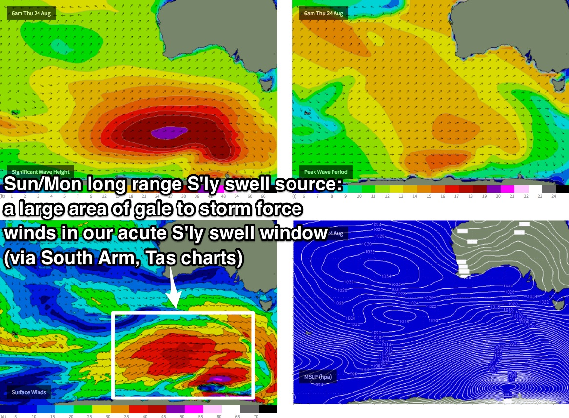
However, we have some interesting long period S’ly groundswell on the way for Sunday. Over the next few days, a series of broad, powerful Southern Ocean lows well to the SW of Tasmania looks like they’ll fire up a rare, acute part of our long range S’ly swell window (see chart below, sourced form our Tasmanian swell charts). It looks poorly aligned on paper, but Southern NSW's Great Circles are distorted by the map projection.
This system should deliver a couple of days of moderate long period S’ly groundswell that will build through Sunday, peaking Monday before easing Tuesday.
The wave models really struggle with these systems, and are currently estimating just 0.4m at 17 seconds Sunday morning. The swell period estimates are on track but we’re probably looking at a metre or more of swell throughout the day, so south facing beaches should see 3-4ft sets with bigger 5-6ft bombs across the Hunter by the afternoon (may be smaller through the morning). In fact, some of the offshore bombies could rake in bigger sets than this too. There will however be long waits between waves; it’ll be well worth the effort though.
As for local conditions, a continental high pressure system will combine with the slow moving Tasman Low to drive a moderate synoptic southerly about the coast. It won’t be terribly strong but it’ll be enough to put a dampener on conditions throughout the day times. However, light W/SW breezes are likely across many locations, particularly through the early-mid morning periods. Sunday looks the best overall.
Next week (Aug 28th onwards)
Sunday’s long period S’ly groundswell should hold in on Monday around 3-4ft at south facing beaches, and up to 5-6ft+ across the Hunter. Expect much smaller surf at beaches will less southerly exposure though.
Size will ease from Tuesday morning onwards. However, a third, final front in this sequence (passing south of Tasmania on Saturday) will set up one more marginally smaller pulse that is expected to arrive across the Far South Coast late Tuesday, reaching Sydney, Hunter and Illawarra beaches early Wednesday. I’ll revise potential size from this in Friday's update but 3ft, maybe 3-4ft south facing beaches and 4-6ft Hunter beaches looks about right for now.
At the same time, the Tasman Low is expected to strengthen through the weekend and maybe early Monday, though still out of alignment for our swell window. We may see some marginally bigger sets from this source on Monday and Tuesday but to be honest the long range southerly signal will probably be the dominant swell train.
Conditions will be clean both days with light variable winds.
Elsewhere, and a developing easterly flow atop a high pressure system north and north-east of New Zealand from Friday onwards looks like it could develop into a small swell source for us next week. It’s expected to interact with the Tasman Low on Saturday, generating strong NE winds from the NE Tasman Sea into the South Pacific, and whilst not especially strong or long lasting, should be enough to generate some fun E/NE swell from Monday afternoon thru’ Tuesday (easing Wednesday) with sets around the 2-3ft mark. It won’t be very consistent but there should be some small waves at exposed beaches.
So, we’ve got a very dynamic period ahead next week.. tune in Friday for more details.
Comments
looks the goods for a sustained long period south swell @ beaches that like that direction for Sun/ Mon. How much swell can we expect from the easterly direction
Ben ? as my locals here love an east swell!