Sunday and Monday have a complex south swell on the cards

Sydney, Hunter and Illawarra Surf Forecast by Ben Matson (issued Friday 11th August)
Best Days: Sat: small clean beachies, best early. Sun: keep an eye out for a pulse of strong S'ly swell, though only at a handful of reliable south swell magnets (biggest and best in the Hunter, in the afternoon). Mon: strong but steadily easing S'ly swell from Sun.
Recap: Persistent S/SE swells have provided good waves for the last few days, coming in around the 2-3ft mark both yesterday and today, though bigger in the Hunter around 4ft. Conditions have been mainly clean with light NW winds.
This weekend (August 12th - 13th)
We’ve got a tricky weekend of south swell ahead. I love these really dynamic systems that develop in funky, remote parts of our swell windows, so the next few days will certainly provide some nail-biting action for myself and the five other regional weather nerds who really enjoy watching these events unfold blow-by-blow.
For everyone else, it’s really about picking where the best window of surf will be. In short, Sunday is your best option, particularly the afternoon.
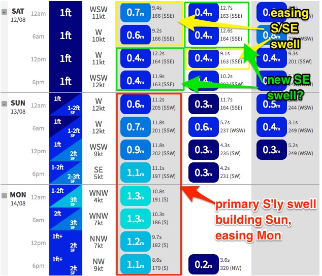
Saturday will begin with easing residual swell from today. There won’t be much left, just 1-2ft at south facing beaches (tiny elsewhere) and the odd bigger set across the Hunter, easing throughout the day. Conditions will however be nice and clean with offshore winds.
Interestingly, the models are showing a small increase in S/SE groundswell on Saturday - not so much in size, but in period. I suspect that this is the SE swell that was expected to arrive today, generated by a complex fetch south and south-east of New Zealand earlier int the week (expected to arrive underneath an existing S/SE swell generated by our most recent Tasman Low).
Model guidance therefore has two swell trains in the water on Saturday - both at just 0.4m, but with the primary swell being the new long range energy at 12+ seconds (the pre-existing, easing S/SE swell will be around 9 seconds).
With the Sydney buoy picking up peak swell periods of around 11-12 seconds today, and with today’s forecast coming in around expectations, it’s hard to assess whether the wave model output is incorrect for today (undercalling swell periods) or tomorrow (overcalling swell periods). Has the swell already arrived, or is it yet to arrive?
I am hesitant to sit on the fence on this one - as the remote swell source wasn’t particularly well aligned within our swell window, so it wasn’t a high confidence event anyway - so I’m going to largely discount this new (modelled) swell for Saturday, and expect small weak surf in general. However if we see bigger surf than forecast, this is where it is likely to have originated from (from this source, I was expecting inconsistent 2-3ft sets out of the SE today).
Anyway, looking towards other swell sources, and very strong front exiting eastern Bass Strait overnight tonight and into Saturday morning is still knife-edge as to its alignment, on the periphery of our acute south swell window.
It’s really hard to emphasis just how much small changes in fetch orientation can affect wave heights. Straight W or W/NW fetches result in zero surf in Southern NSW, but a W fetch with a slight hint of W/SW - if it’s strong and sustained enough - can deliver decent lines of southerly energy. SW fetches are great, though they still result in a wide range in surf size between exposed and protected beaches.
In this case, the initial alignment is poor but a similarly strong secondary front will maintain gale to storm force westerlies for longer than usual (in the lee of the first front) which increases the surf potential significant from what would have otherwise been a write-off.
For the most part, Saturday is unlikely to see any of this new swell, as the fetch develops a little too late for there to be an appreciable increase before sunset. However we are likely to see a couple of phases of south swell appearing from overnight Saturday into Sunday, persisting all day but with the biggest round of energy slated for the afternoon.
I can’t say I’m overly confident on this event delivering the goods, but the best estimate at this stage is for 1-2ft surf at south facing beaches through the morning (tiny elsewhere), building to 3ft into the afternoon - though I am expecting there to be a greater percentage of beaches that don’t see much much surf, compared to most south swells - only truly reliable south swell magnets will be in the firing line. This will be a pretty steep event and it’ll largely bypass much of the Southern NSW coast.
That being said, the Hunter always does much better with these swells so the late session on Sunday could be pushing 4-5ft+ right on dark.
Anyway, there’s no need to rush down on Sunday morning as I reckon the swell may be slow too build through the morning. We’re looking at light variable winds all day, so there should be clean options into the afternoon.
Next week (August 14th onwards)
If anything, Monday morning may see the peak of this south swell event, but wave heights will taper off rapidly throughout the day (let's hope it doesn't peak overnight). We’re looking at 3ft+ sets at south facing beaches around dawn easing to 2-3ft by mid-late morning and then 2ft into the afternoon.
Expect much smaller surf elsewhere, though the Hunter will (as usual) see larger surf. Conditions will be clean with mainly light to moderate NW winds.
Small, residual S’ly swells will then pad out Tuesday ahead of a couple of tiny, windy offshore days as a series of vigorous fronts cross the coast.
It looks like we could be in for a repeat of the Sun/Mon funky south swell phenomena later next week, with a similar synoptic pattern progged for Thursday that should give rise to a steep southerly swell event around Friday morning. This event could end up being a little bigger than the forthcoming swell too, and may also last a little longer. But we’ll need a few more days to assess the model output.
Have a great weekend!
Comments
Latest ASCAT data looks good with two seperate fetches now in the water. IMO, there's no need to change outlook for tomorrow at this stage. Will see how this evening's passes come in though (and tomorrow morning too).
Latest model data has however backed off the swell (knocking a foot off the size, and a few seconds off the period). Hmmmm...
As a resident of the Hunter all I can say is bring it on!
Cool pseudonym
Yeah, yeah...
Well hello there, complex south swell!
We've got small lines in Sydney around 1-2ft but this new energy is already pushing 3ft+ in Newcastle. Forecast is still on track for a bigger increase throughout the day too.
Small clean lines at Cronulla:
Ditto at Maroubra:
And not a lot at Manly, as you'd expect under a straight S swell:
But.. whoa! Newcastle is strong and consistent, and clean too. Bring it on!
Looks like we're getting close to forecast size expectations.
The Botany buoy has increased by half a metre since the morning reports, and periods have come up a couple of seconds.
Newcastle is showing strong sets around the 4ft, maybe 4-5ft range:
Maroubra is inconsistent, but around 2ft, occ almost 2-3ft (so, Bondi should be a fairly solid 3ft):
Cronulla seems to be similar to Maroubra, inconsistent 2ft, almost 2-3ft.
Seems like the swell peaked overnight; we are already on the backside of this pulse. Newcastle looking terrible once again:
Still some decent sets coming through at Maroubra:
Nice lines across the Cronulla Shire too:
Sun glare is awesome for showing swell lines, banks and gutters.
Exhibit A, Cronulla: