Small swells in Southern NSW for the foreseeable future

Sydney, Hunter and Illawarra Surf Forecast by Ben Matson (issued Monday 20th February)
Best Days: No great days in general. A small S'ly swell expected Wed will probably be wind affected. Thurs has a chance for a small mix of S'ly groundswell and peaky NE swell with light winds, though confidence is low on both swell sources.
Recap: Saturday’s NE swell was disappointingly smaller than expected. Wave heights began easing around 12 hours earlier than forecast (Friday evening, rather than Saturday morning) so by dawn Saturday we were left with weak 1-2ft waves at most beaches. A southerly change then pushed in early-mid morning, and created bumpy conditions for the rest the day. On Sunday, conditions were bumpy under a southerly flow but this local airstream built a short range S/SE swell across the coast with sets around the 3ft mark by the afternoon. It’s eased back in size today but conditions have been much better with light offshore winds.
This week (Feb 21st - 24th)
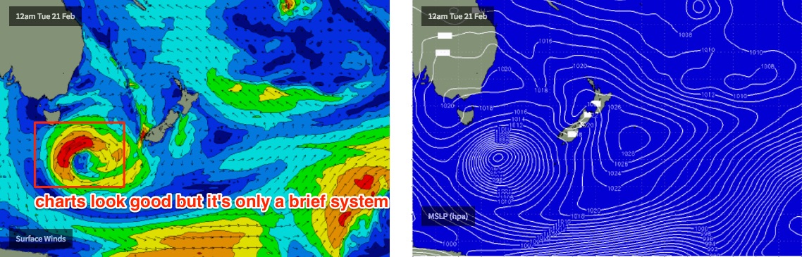
The weekend’s coastal trough is consolidating into a broad low S/SE of Tasmania at the moment. However, despite an impressive spatial size, it has a few limitations - wind speeds are not terribly strong right now, and the fetch length around the low’s western flank is not especially long.
Additionally, the low is sliding to the south as it continues to develop, which is slightly counter-productive for quality swell generation.
As such the models are not very keen on this event at all, even though the synoptic chart shows a very deep cut-off low pressure system. In fact, at a quick glance of the swell train analysis you’d be forgiven for thinking there was hardly any south swell on the way at all. It has a minor swell event (0.5m at 9 seconds due south) arriving overnight Tuesday (a little earlier down south), building slowly through Wednesday, but I think this is probably a slight undercall in both its size and period values.
Prior to the arrival of this south swell, we are looking at a marginally smaller version of today’s minor S/SE swell holding into Tuesday morning, with light variable winds swinging E/NE into the afternoon and freshening. Expect wave heights to ease throughout the day.
Winds will then freshen from the NE throughout Wednesday as a front approaches from the west. The aforementioned southerly swell should build throughout Wednesday, with very inconsistent 2-3ft sets at south swell magnets by the afternoon (a little smaller earlier) and not a lot elsewhere. We should however see a building NE windswell into the afternoon.
The models are holding Wednesday’s south swell into Thursday - in fact, peaking it in size around lunchtime (0.6m at 12.6s). I’m a little cautious on this prediction because of the way the low will form over the coming days - the peak in swell periods fits in with the surface wind timeline, but as the low reaches maturity and therefore maximum strength, it’ll also be angling away from our swell window. So I am doubtful for much size from the tail end of this development.
Therefore, Thursday has a chance at beginning close to Wednesday afternoon’s size peak but will probably trend quickly downwards throughout the day. I’m expecting this south swell (both Wed and Thurs) to be quite inconsistent and flukey; that is - not favouring every south facing beach like we commonly see from nearer, more distinct swell sources.
We may also see some small NE windswell in the water on Thursday, though the models have a weak low forming off the coast so local winds will be variable. And the small NE windswell present early morning will tail off during the day.
Smaller surf with light winds tending NE is the most likely solution for Friday.
This weekend (Feb 25th - 26th)
The weekend looks a little ordinary at this stage.
We’ve got an advancing cold front on the charts that’ll clip the coast early Saturday, bringing gusty southerly winds to most regions. Surf size will build during the day but quality won’t be very good, south facing beaches should see some 3-4ft sets by late afternoon.
Sunday will see slowly easing S’ly winds and easing S’ly swell. South swell magnets may again pick up 3-4ft sets early morning but there’s only an outside chance for a brief early SW wind.
Let’s check in again on Wednesday to see if things are looking a little better. But right now it doesn’t look especially great.
Next week (Feb 27th onwards)
There’s nothing major standing out in the long term charts that’ll influence Southern NSW right now. If anything, the trades look like they’ll reinvigorate across the Northern Tasman and Coral Sea, but that would only affect Southern NSW peripherally by way of a minor spread of E/NE swell.
Hopefully I'll have better news in a few days time.
Comments
Onion rings with no juice. Bom site makes it look ok, although not well that aligned.
Might be a bit of size in that SE swell for Surfest, slight upgrade on the charts maybe..
Some signs of that swell this afternoon on the NB. Regular lines at 2ft, not too far apart.