Strong south swell Tuesday; funky weekend; then dynamic sources next week

Sydney, Hunter and Illawarra Surf Forecast by Ben Matson (issued Monday 13th February)
Best Days: Tues: strong S'ly swell with a brief period of good winds north of the 'Gong. Wed: early light winds and easing S'ly swell. Sat, poss Sun: fun mix of peaky swells with mainly good winds. Next week: strong S thru' SE and also E/NE swell possibilities (read on!)
Recap: Plenty of E/NE swell over the weekend. Wave heights pulsed in and around the 2-3ft mark and winds were light in the mornings, ahead of freshening N/NE breezes Saturday and S/SE breezes Sunday. Today we’ve seen a solid kick in S’ly groundswell, with most Sydney beaches reaching 4-5ft, and some reliable swell magnets pushing 6ft at times. Winds were light offshore early but have swung moderate S’ly then SE during the day.
This week (Feb 14th - 17th)
No shortage of swell for the short term.
A broad, vigorous frontal pattern through the lower Tasman Sea and Southern Ocean has a couple of secondary fetches that will generate new swell for Tuesday and then late Wednesday thru' Thursday.
Initially, strong SW winds pushing northeast of Tasmania (and eastern Bass Strait) should maintain current size levels through Tuesday, but there’s a risk of a developing S’ly breeze through the morning as a front pushes north along the coast. The early morning should see a brief period of light W/SW winds; this is more likely north of the Illawarra so expect dicey conditions south of here. South facing beaches should see 4-5ft sets, possibly 6ft at some of the more reliable south swell magnets (especially the Hunter region). But it’ll be much smaller elsewhere due to the direction. Surf size may trend downwards into the afternoon.
This swell will then ease through Wednesday with early light winds and sea breezes. South facing beaches should still have plenty of 3ft+ sets early though.
Additionally, a weaker secondary polar low and front (the low positioned around 62S, 157E this morning) is driving a small pulse of S’ly swell that’ll fill in from late Wednesday and into Thursday and maybe early Friday. It’s not a particularly strong fetch but it’s well placed within the swell window, and I think the models are undercutting the potential from this source (just 1ft Thursday morning?). You can however see the swell periods draw out slowly from about 180 degrees from late Wednesday (12.6 seconds) then ease back into the mid 11 second range through Thursday and Friday. Set waves will be very inconsistent but south facing beaches should pick up straight 2ft+ sets through Thursday and maybe early Friday.
A minor ridge through the northern Tasman Sea mid-week won’t be very well aligned for our coast but should contribute a small spread of E/NE swell through the latter part of the week. We’ll also see freshening NE winds locally on Thursday and Friday, with small windswells a distinct possibility (Friday afternoon has the most size potential with occasional 2-3ft bombs at NE swell magnets if we’re lucky). However local conditions will probably be a little ratty under these winds.
This weekend (Feb 18th - 19th)
There’s a couple of sneaky swells on target for the weekend.
First up - over the last month or so I have detailed a small region of the ice shelf S/SE of New Zealand that’s harboured a number of stationary polar lows - quite unusual for so many of them to appear in such a short space of time.
This region is expected to flare up again over the coming days with a small but very tight fetch of 40-50kt+ winds. I'm expecting this to generate a minor S/SE groundswell exhibiting 15 second peak periods, arriving early Saturday morning. Again, confidence is never high for these remote swell sources but reliable south swell magnets could see very inconsistent 2ft to almost 2-3ft sets at times throughout the day (biggest in the afternoon). I’ll reassess on Wednesday with the benefit of hindcasting and satellite observations.
Otherwise, we’re looking at a blend of small E/NE trade swell (spreading from the northern Tasman Sea down), plus some local NE windswell from the local fetch, the latter of which could produce 2-3ft+ sets early Saturday morning.
All swell sources are likely to ease slightly into Sunday.
As for local winds - a broad troughy pattern over Southern NSW should result in variable winds though northerlies are a possibility across northern locations (i.e. Hunter coasts) on Saturday. The models have a weak surface low forming on Sunday so wind direction could go either which way, but at this stage it’s not expected to be a major swell producer.
Next week (Feb 20th onwards)
There’s a heck of a lot of potential swell on the cards for next week.
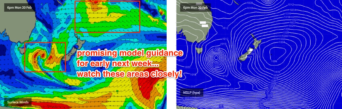
Locally, we have a number of crucial ingredients starting to take shape in our near swell window - a broad, slow moving surface trough close to the mainland, an approaching upper level trough and cold pool from the west, plus an infeed of tropical moisture from an active monsoon passage across the northern part of the country and also the tropical South Pacific. This could result in a major swell generating system in the Southern Tasman Sea sometime early to mid next week.
Additionally, this same broad tropical pattern is expected to spawn a tropical low (and/or possible tropical cyclone) in and around the Fijian region this weekend, which should evolve into a significant E/NE swell machine in the South Pacific by early next week, favouring a large swathe of the East Coast of Australia. Check the (modeled) high pressure system just east of New Zealand for Monday (below).. it's a beast!
Overall, it’s still very early days so specifics are much too broad to assess, but there’s plenty to look forward to in Wednesday’s and Friday’s Forecaster Notes.
Comments
Yew! Hopefully rain for my lawn too!
Ooo. Heading to Fiji next week. Few beat downs out cloudbreak could be on the cards.
Gonna head up to Frigates again, Mibs?
Ben, any chance of an offshore tomorrow morning? Cheers