Average surf for the coming days; solid S'ly swell due Tuesday

Sydney, Hunter and Illawarra Surf Forecast by Ben Matson (issued Wednesday 24th August)
Best Days: Hard to get excited about the next few days due to funky winds and flukey swell sources. Monday looks good for a small clean south swell though, and Tuesday has a possible large S'ly swell - though with N/NE winds.
Recap: Small surf and moderate SW winds padded out Tuesday, with a minor increase today decimated by a strengthening S/SE tending SE breeze across many coasts. Interestingly, winds have been light NW across the Hunter region thanks to the development of a small local low pressure system (winds are rotating around the low, which seems to be midway between the Central Coast and Newcastle region).
This week (Thursday 25th - Friday 26th)
The developing low off the Central/Hunter coast today should see a modest E/SE infeed overnight before the low is whisked away to the east, outside of our swell window.
This should maintain peaky 3ft surf across exposed parts of the Sydney and Hunter coasts into Thursday morning but smaller waves will prevail elsewhere, being a combo of minor long period E’ly swell from late last week’s low way out past New Zealand, and some small S’ly energy from a polar low well SE of Tasmania on Sunday.
Local winds on Thursday look tricky, as locations close to the low (i.e. anywhere north of Wollongong) could see a strong influence, meaning some form of gusty southerly breeze. But the trend should improve all day as the draws away from the coast, with the synoptic wind expected to veer more south-west.
The wave models are maintaining plenty of short period S’ly swell into Friday but I don’t think it’ll result in very much quality surf. The responsible fetch is expected to lie parallel to the Southern NSW coast on Thursday, but its width is not expected to be very wide, and wind speeds are expected to remain at or below 20kts, which reduces the wavelength (period) potential.
As such we’ll probably see small peaky waves at south facing beaches around the 2ft mark on Friday, probably a little bigger across the Hunter region. Expect a smaller combo of swells at remaining beaches. A small pulse of mid range S’ly swell is expected throughout the late afternoon from a front entering the lower Tasman Sea on Thursday, but its arrival time has been put back and I’m doubtful we’ll see any appreciable increase (no major size was expected anyway).
As for local winds, a persistent troughy pattern off the coast will maintain some form of southerly breeze on Friday - which will bump up those south facing beaches picking up the most some - however we should see an early period of SW winds in many regions during the morning.
This weekend (Saturday 27th - Sunday 28th)
No changes to the weekend outlook - it’s still expected to be mainly small from the south.
Saturday should retain a similar level of slow surf as per Friday, with occasional 2ft sets at south facing beaches and smaller waves elsewhere. Light W/NW winds should keep conditions clean. Wave heights may trend down a little during the day.
The models have a small long period S’ly swell encroaching the Southern NSW coast on Sunday, but I’m skeptical to its origins - a polar low skirting the ice shelf well south of Australia on Thursday and Friday. This system is a very long distance from our coastline, and it’ll be working right on the periphery of our swell window so it’s hard to have confidence in the likely size.
Model guidance has the leading edge pushing into the South Coast during the morning (probably not at dawn), reaching the Sydney region mid-late afternoon. Most of the ’surfable’ part of the swell will probably be located some 12-18 hours behind this, so Monday is a safer bet for an increase across the Sydney and Hunter coasts, but we may see an afternoon pulse across the South Coast to 2-3ft, with very long breaks between waves.
Otherwise, Sunday is looking at small residual energy in and around the 1-2ft mark at south facing beaches, with smaller surf elsewhere. Conditions should be clean with light offshore winds.
Next week (Monday 29th onwards)
Sunday’s late pulse of inconsistent long period S’ly swell should provide slow, infrequent waves to south facing beaches on Monday morning, somewhere in the 2-3ft range.
However, a much larger, deeper and better aligned low/front is expected to track north-east through the Far Southern Ocean up into the lower Tasman Sea on Sunday, and this will generate a solid pulse of long period S’ly swell for Southern NSW on Tuesday. Early indications suggest core wind speeds of 50kts on a broad active sea state generated by the previous front, which increases the size and period prospects from this system.
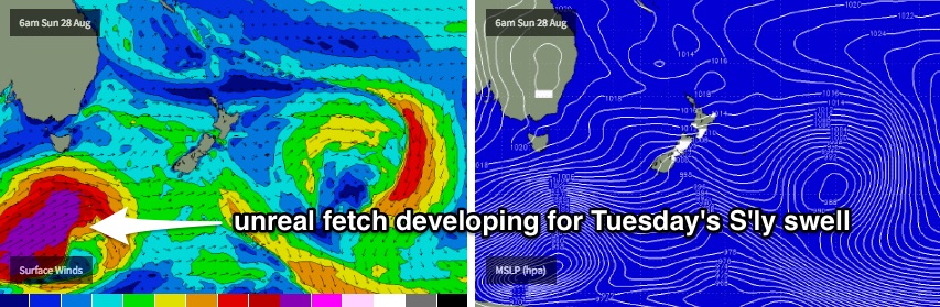
At this stage I think we’ll see some large surf from this system across south facing beaches, somewhere in the 4-6ft range (though, we are out towards the end of the model run, so let’s give it a few more days). If things pan out as currently forecast, the larger periods should produce much bigger waves at offshore bombies across the region (i.e. 8ft+).
The only concern is that this swell may be accompanied by a freshening N/NE breeze as a broad ridge of high pressure develops in the Tasman Sea. Let’s wait and see how Friday’s models are looking.
Comments
fingers crossed everything fall into place.
Conditions improved much faster than expected this morning, and the east swell is a smidge bigger than expected. Manly looks pretty fun:
https://www.swellnet.com/surfcams/manly