Great winter waves ahead

Sydney, Hunter and Illawarra Surf Forecast by Guy Dixon (issued Wednesday 6th July)
Best Days: Early each morning.
Recap:
Size has been lacking across the NSW coast over the past couple of days, with little more than 1-2ft breaking. On the plus side, persistent offshore breezes have kept conditions perfectly groomed for the desperate ones amongst us.
Exposed south facing beaches have been picking up the first signs of southerly energy this afternoon, but not much in terms of size, just 1-2ft at the most.
This week (Thursday 7th - Friday 8th):
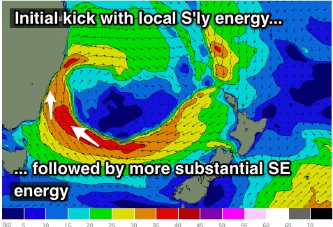
The hints of southerly energy which we have been picking up across exposed south facing beaches this afternoon will build overnight and into Thursday as a result of a southerly tending southeasterly airflow steered by a cut-off low sitting off the NSW coast.
Up until this afternoon, the main fetches along the southern quadrants of this low have been blowing perpendicular to the South Coast, but should swing more southerly and whip up the coast overnight.
The initial kick in size will primarily be short range southerly energy, followed by stronger southeasterly energy in the late afternoon and into Friday morning generated by more distant southeasterly fetches of around 35-45kts.
Exposed south facing beaches should see sets build to the 6-8ft range by mid-late morning on Thursday, holding at a similar size for the majority of Friday as the more substantial periods fill in and the swell direction swings more southeasterly.
 Typically under a southerly swell regime, beaches along the Hunter coast pick up more size which is likely to be the case this time round, although as the swell direction tends more southeasterly, surf size should become more uniform across the coast.
Gusty southwesterly breezes will soon tend south/southwesterly on Thursday morning, limiting options somewhat to more protected open beaches. Exposed south facing beaches and most spots along the Hunter are more likely to be susceptible to a cross-shore breeze.
Similarly, Friday morning should offer early southwesterly breezes, giving way to a lighter south/southeasterly breeze during the mid-late morning. Southern ends of open beaches should be workable in the afternoon as a moderate southerly airflow dominates.
This weekend (Saturday 9th - Sunday 10th):
Despite weakening, the southeasterly fetches over the central Tasman look to project towards the coast slightly which should maintain a good amount of energy on Saturday. Sets should gradually ease from around 5-6ft on Saturday, more so on Sunday from the 4-5ft range.
In Monday’s notes we discussed a good looking east/southeasterly fetch anchored off Cook Strait, although the more recent model runs have down played the size and elongated nature of this system. Nevertheless, we should still see a fairly distinct kick late on Sunday (close to dark) where strong sets around 3-5ft should fill in.
Meanwhile, inconsistent southerly energy generated by Southern Ocean frontal activity should provide an underlying groundswell, but likely overshadowed by the existing southeasterly energy.
A similar wind pattern is on the cards for Saturday with early west/southwesterly breezes gradually tending lighter south/southeasterly into the afternoon. Sunday looks to start off in a similar fashion, although the outlook then becomes unclear. Some models have a variable flow in the afternoon, others increasing from the northeast.
Next week (Monday 11th onward):
Continued energy off the back of the aforementioned Cook Strait is expected to maintain sets in the 3-5ft range on Monday morning, easing throughout the day as the fetch becomes shielded by New Zealand’s North Island.
Monday morning is looking good for a wave under a north/northwesterly breeze, potentially tending north/northeasterly into the afternoon.
Conditions should become small mid-week as the Tasman swell windows become dormant.
More detail on Friday.
Comments
Is it still forecasted to be 6-8ft for the majority of Friday Guy?