Plenty of size to finish the week, wind causing issues

Sydney, Hunter and Illawarra Surf Forecast by Guy Dixon (issued Wednesday 3rd February)
Best Days: Sunday morning, Monday morning and Tuesday morning.
Recap:
We’ve had a bit of a lull this week, with only small options in the 1-2ft range breaking along the coast. Winds have been generally light and workable each morning preceding afternoon seabreezes.
This week (Thursday 4th - Friday 5th):
We are finally due for a bit of size to finish off the week, but don’t get too excited yet, breezes look to cause a few issues.
Winds are due to swing gradually swing southerly and increase overnight this evening and into Thursday, generating a building southerly windswell across south facing beaches on Thursday.
By the afternoon, exposed beaches look to build to a poor quality 3-4ft range, larger across the Hunter but severely impacted by the local southerly winds that are generating it.
This southerly change is associated with a much larger scale low pressure system which is currently deepening over central parts of the Tasman.
The surf is expected to gain a touch more size throughout Friday as the impacts of this low fill in from central/southern parts of the Tasman Sea. Marginally higher swell periods will lead to a touch more power and quality of the swell, however gusty south/southeasterly breezes will continue to lead to choppy conditions in the 3-5ft range.
This weekend (Saturday 6th - Sunday 7th):
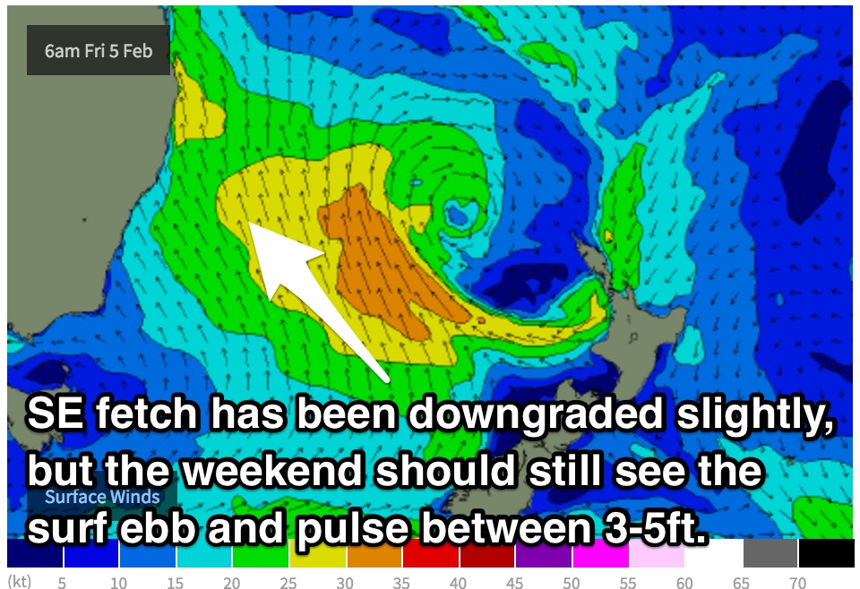 For the early risers on Saturday, the surf is expected to be holding at a similar size to Friday with sets in the 3-5ft range, however further intensifications of a south/southeasterly fetch in the days prior should provide another subtle kick for Saturday afternoon.
In addition to this southeasterly energy, a second source of long range energy looks to fill in from when the low was in its infancy (Wednesday evening into Thursday).
On the eastern flanks of this system, the pressure gradient is beginning to tighten as it squeezes up against a strong ridge over New Zealand. As a result, northeasterly fetches of 25-30kts are currently blowing and are set to increase into Thursday with core fetches up to 35kts.
The resultant east/northeasterly swell generated by this fetch is expected to fill in late on Friday into Saturday morning with options in the 3ft range for the open beaches.
Sunday morning should still be showing options in the 3-5ft range although fading throughout the day as the tail end of the Tasman fetches fill in.
Meanwhile, frontal activity over the Southern Ocean earlier in the week should add an element of southerly groundswell into the mix, allowing south swell magnets gain around 3ft by the late afternoon, fading slowly throughout Sunday and Monday.
As for the wind scenario, it’s not looking perfect, but better than the days leading up to the weekend.
Protected southern corners will be the way to go on Saturday as a moderate southeasterly breeze dominates the coast. The east/northeasterly groundswell should come in handy making an otherwise frustrating day fairly workable.
As for Sunday, the early session should offer light southwesterly breezes, tending southeasterly and increasing throughout from late morning.
Next week (Monday 8th onward):
All swell sources are expected to fade throughout Monday from the 3-4ft range, before an east/southeasterly fetch over Cook Strait slows the easing trend.
This system has been downgraded in both size and intensity over the past couple of days, but still looks to provide 2-3ft of inconsistent swell across the NSW coast on Tuesday. While the remaining swell windows quiet down, this should slow the easing trend maintaining fun options under early morning southwesterly breezes, becoming seabreezey each afternoon.
Comments
Ain't no shortage of size at Bondi this morning.