Fading S'ly Thurs, E'ly trade-swell thereafter

Sydney, Hunter and Illawarra Surf Forecast by Guy Dixon (issued Wednesday 2nd December)
Best Days: Friday morning, Saturday morning, possibly Sunday morning and Wednesday morning
Recap:
Small easterly swell was on the menu on Tuesday, providing slow peaks in the 2ft range across the Hunter, slightly smaller further south. The morning session offered light northwesterly breezes across the Hunter, more northerly along the Sydney and Illawarra coasts. A seabreeze soon kicked in, further hurting the chances of a decent wave.
This morning, we woke to options in the 2ft+ range under southerly breezes, however the surf has since grown the the 3-4ft range at south facing beaches following the change. As for quality, there isn’t much. Local southerly breezes are taking their toll.
This week (Thursday 3rd - Friday 4th):
The forecast over the coming week is looking pretty straight forward, with only one dominant swell in the water from Friday.
The only exception to this statement will be an easing southerly windswell which we saw today in the wake of last night’s southerly change.
South facing beaches are expected to ease from the 3-4ft range on Thursday, accompanied by an easing south/southeasterly airflow. The quality of the surf at these locations is not expected to be anything amazing, with plenty of bump in the mix.
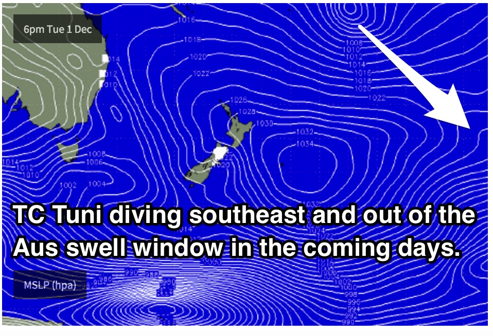
Open beaches will be offering cleaner options, particularly at protected south ends way from the breeze. Although inconsistent, a workable amount of trade energy is likely to fill in, with the surf holding in the 2ft, occasionally 3ft range. We could see a small increase in size late in the day (more likely Friday) from an intensification in the fetch (Tropical Cyclone Tuni) earlier in the week. TC Tuni will dip southeast in the coming days, undergoing extratropical tranisition and moving out of our swell window.
 With the exception of small southerly left overs, this easterly trade-swell will be the dominant swell in the water on Friday, with open beaches seeing the most action. The surf is likely to hold in the inconsistent 2-3ft range throughout the day, under a light/variable breeze early, tending east/northeasterly and increasing slightly throughout the day.
This weekend (Saturday 5th - Sunday 6th):
The weekend is also likely to be dominated by easterly trade-swell, likely peaking in the 3ft range on Saturday and possibly Sunday morning although remaining very inconsistent. There is the outside chance of the occasional 4ft set in the mix, but these will be few and far between. Sunday should then see this swell gradually fade.
Weak frontal activity passing over the southern Tasman on Friday and Saturday will add a tiny amount of southerly energy into the mix for Sunday, however it’s impacts will be negligible. South facing beaches will be lucky to see 1-2ft off this swell.
The wind outlook is looking good for Saturday morning, with light northwesterly breezes on the forecast for the morning session. As the day progresses, the quality across the open beaches will deteriorate as a northeasterly seabreeze develops.
Sunday also has the potential to see a period of light/variable/offshore breezes in the morning, before swinging southerly. Open beaches should remain workable during the afternoon, particularly at protected southern corners.
Next week (Monday 7th onward):
The gradual easing trend is expected to continue throughout Monday, fading from the 2-3ft range, further on Tuesday, fading from the 2ft range.
Winds are looking light early on Monday, tending east/northeaterly and increasing throughout the day.
Tuesday is in for a north/northeasterly airflow from the get go, making for some pretty ordinary conditions across the open beaches which will be offering the biggest swell. Late in the day, these local breezes should have whipped up a small, short range northeasterly windswell to around 2ft, without much quality to speak of.
A second long range southerly groundswell looks to fill in late on Tuesday, likely peaking on Wednesday generated by a frontal progression moving over the Southern Ocean during the late stages of the weekend. In comparison to the weekend’s southerly pulse, this one looks to be a touch bigger, providing inconsistent 2-3ft sets across south facing beaches.
Assuming the swell comes in, Wednesday morning is looking fun under a northwesterly breeze preceding a southerly change. Sure enough, the timing will vary and firm up as we get closer to the date.
Comments
Some nice waves across the Northern Beaches this morning - Manly's picking up the long range E'ly swell quite nicely.