Great surf developing Thursday, long-range E/NE swell next week

Sydney, Hunter and Illawarra Surf Forecast by Guy Dixon (issued Wednesday 25th November)
Best Days: Thursday mid-late morning and Sunday morning
Recap:
A southerly groundswell provided peaks in the 3-4ft range across the Sydney and Illawarra stretch yesterday, with the most energy in the afternoon as the tide was at it's lowest. An easterly breeze was established from the get go, although the quality remained fair in the morning. As the afternoon progressed however, northeasterly breezes increased and conditions took a hit. Further north, the surf was in the 3-5ft range, although lacked quality and shape virtually all day.
This morning started off with surf in the 3ft range, however a lot of the energy was masked by the morning high tide. A southerly pulse filled in around mid-late morning, however didn't provide much more size, but instead maintain surf in the 3ft size across the Sydney Coast. The Hunter did better, with options occasionally reaching 4ft. Conditions were clean earlier, but have since become limited to northern corners under a northeasterly airflow.
This week (Thursday 26th - Friday 27th):
 A deep inland trough is currently moving over inland NSW and is interacting with a strong ridge over the Tasman Sea. As this trough deepens and moves offshore in the early hours of Thursday, a northerly airflow will increase off the coast of NSW whipping up a local northeasterly swell.
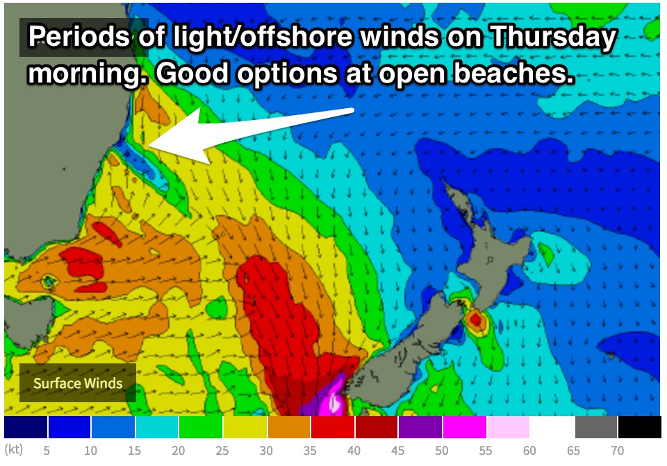
Winds have been increasing this afternoon, but are likely to peak in the early hours of Thursday, allowing northeast facing beaches to build to the 3-4ft range by daybreak, fading through the afternoon.
The quality of the surf in the early morning isn’t likely to be anything special, with gusty northerlies persisting until just before dawn. However the late morning looks to offer a period of offshore/slack winds preceding a southerly change which is due to move up the coast in the afternoon/early evening.
Also in the mix will be the remnants of today’s southerly swell, fading from the 2-3ft mark at south facing beaches, larger across the Hunter.
Keep your options open during the mid-late morning hours, because there is a good chance of some great waves at these northeast facing beaches. As the afternoon progresses, the southerly change will have an impact, limiting options to protected southern corners.
Gale force winds off the far South Coast during Thursday morning have the potential to generate plenty of short-mid range southerly swell for Friday morning. South facing beaches can expect average quality peaks in the 3-5ft range, accompanied by an onshore flow persisting all day.
Gusty breezes in the wake of Thursday’s change are not expected to be sustained for overly long. In fact, Friday morning, is looking at moderate southeasterly breezes easing and tending northeasterly. However, without a period of offshore breezes, we shouldn’t expect anything amazing.
Open beaches will be offering the cleanest options in the morning, before deteriorating as breezes swing northeasterly. As for size at these open beaches, very little southerly energy will be getting in, however we are expecting to see a small amount of east/northeasterly trade swell, generated by a tropical depression located north of Fiji.
This weekend (Saturday 28th - Sunday 29th):
As we move into the early stages of the weekend, southerly energy will fade gradually from the 2-3ft range across south facing beaches.
Southwesterly trailing fetches moving east of Tasmania on Friday will maintain a small amount of southerly energy for the south facing beaches on Sunday, although they’d lucky to crack the 2ft range, perhaps a touch more size across the Hunter.
Northeasterly breezes are likely to persist right through Saturday, strongest in the afternoon so conditions aren’t looking overly special. South facing beaches will be the best bet, but even then, places like Bondi which do well on a north/northeasterly breeze will be on the brink of being bumpy.
A steady stream of east/northeasterly energy will also fill in across open beaches throughout the weekend generated by a tropical depression just north of Fiji. The effects of this system will be subtle, with options in the 1-2ft range each day.
A more dominant northeasterly swell is on the cards for Saturday afternoon, peaking Sunday as a northeasterly fetch sets up off the NSW ahead of the next trough. This system is looking much less broad and intense than Thursday’s, so we can only expect 2ft+ peaks at open beaches on Sunday morning.
Fortunately, breezes look to be much more cooperative on Sunday morning (despite model disagreement). Winds are likely to drop and prevail from the northwest, before tending southerly. Friday’s notes will have more detail on the timing of the southerly change.
Next week (Monday 30th onward):
Sunday’s change is not looking overly strong, so the amount of short range southerly energy will be fairly benign.
We are setting our sights on the open beaches for the early stages of next week as the eastern and northeastern swell windows look to be the most active.
With the exception of small and subtle northeasterly wind swells, the major swell generator looks to be the tropical depression mentioned earlier. By Tuesday, we are hoping for open beaches to be picking up surf in the 2-3ft range throughout the day.
The synoptic set up is looking fairly changeable this far out, but the dominant synoptic feature over eastern Australia looks to be a high pressure ridge, so we can say with fair accuracy that winds will be light and variable early, becoming seabreezey in the afternoon.
More to come on Friday.
Comments
Southerly change has just hit Manly, here it is creeping in on the cam..