Fresh S'ly groundswell due early next week

Sydney, Hunter and Illawarra Surf Forecast by Guy Dixon (issued Friday 20th November)
Best Days: Monday Morning, Tuesday morning, Wednesday morning and Thursday morning.
Recap:
A mix of swells were in the water on Thursday, although small and weak. A northeasterly windswell rivalled an underlying southerly groundswell for size throughout the day with options in the 1-2ft range for most locations for most of the day. Light offshore breezes made for clean conditions in the morning, however even when winds swung onshore, the surf was workable as the airflow was light.
Today, we have a southerly swell offering options in the 2ft range for the magnets, smaller elsewhere. The early risers were greeted with a funny southerly breeze and bumpy conditions, however breezes soon righted themselves and tended northwesterly as forecast.
This weekend (Saturday 21st - Sunday 22nd):
Following a particularly slow end to the week, more size is on the cards for the start of the weekend.
A gusty southerly change is likely to move up the coast late this evening, generating a short range southerly swell which will be in the water for Saturday morning. South facing beaches are expected to be offering options in the 2-3ft range, however the quality of the surf will be compromised by persistent and gusty southerly breezes in the wake of this change all day.
Also in the mix will be the tiny remnants of a southerly groundswell which was a bit of a no show earlier in the week. The effects of this underlying swell will be minimal and likely overshadowed by the short range energy.
Protected southern ends of open beaches are likely to offer much cleaner options, however the size will be dramatically reduced due to the swell direction and like of refraction potential.
The surf is likely to hold in the 2ft to occasionally 3ft range at south facing beaches on Sunday, although gradually easing as the day wears on. Light/moderate southeasterly breezes are expected to gradually swing around to the northeast by the afternoon while easing. As for the South Coast and Illawarra, the early southeasterlies look to be light, however the afternoon northeasterlies are expected to increase and become quite gusty in the late afternoon.
Next week (Monday 23rd onward):
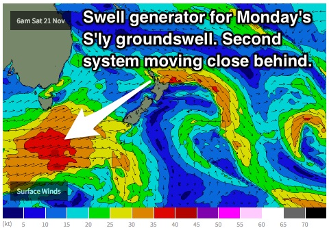
Early next week is when we see the next best chances of significant groundswell.
Models have been set on a broad frontal progression due to move south of Tasmania and across southern parts of the Tasman throughout Saturday, steering a very broad fetch of west/southwesterly winds in the 35-40kt range.
 A second front with a slight intensification is expected to pass to the south of Tasmania on Sunday morning and across southern parts of the Tasman throughout the day. Winds of a similar strength and direction are expected, although not covering such a broad area.
The initial front is likely to whip up a strong kick in southerly groundswell building to the 3-5ft range on Monday afternoon at south facing beaches, smaller at open beaches which will rely on the 15 second swell period for refraction. The Hunter should see sets more to 4-6ft.
Tuesday should see south facing beaches hold at a similar size range, with a slight increase in swell period to the 16 second range as the next swell front fills in that morning.
Breezes are looking good for Monday morning with a light/variable-offshore airflow increasing from the south/southeast in the afternoon. The South Coast more likely to be under this moderate southeasterly breeze from earlier in the day.
Again, Tuesday morning is likely to see clean conditions under a light/variable breeze, increasing from the northeast in the afternoon.
A small amount of local windswell may be generated as these local breezes increase each afternoon, particularly a small northeasterly windswell on Tuesday, however their effects will be weak and undersized with not much quality.
West/northwestesterly breezes in the 25-30kt range will continue over the Southern Ocean in the wake of Tuesday’s system, maintaining a small element of energy throughout for Wednesday and Thursday. Due to the poor alignment, we don’t consider this swell anything significant, just background energy slowing an easing trend.
Wednesday should fade from the 2-3ft range at south facing beaches, with a small amount of northeasterly swell providing weak peaks in the 1ft range at open beaches.
Thursday has the potential to see a small period pulse generated by intensifications in the frontal activity earlier in the week, bumping south facing beaches to the 2-3ft range in the morning, fading there after.
The wind scenario for Wednesday looks decent in the morning, with light northwesterly breezes prevailing. However, the situation then becomes more complex and these northwesterly breezes increase to fight an increasing northeasterly breeze in the afternoon. At this point, the seabreeze boundary looks to hang over the coast, so I’d put my money on the surf being wind affected from the northeast.
Similarly, Thursday’s best window of opportunity falls in the morning under a northwesterly breeze preceding a gusty southerly change later. This is good news as it coincides with the brief period pulse in the morning.
Further ahead:
The longterm outlook is looking much more active than what we’ve seen in recent times. Models indicate a strong node of the long wave trough to develop over eastern Australia and the Tasman which bodes well for swell generating frontal activity.
Fingers crossed.
Comments
Sydney Airport reached 42.8 degrees around 45 minutes ago. Gonna be a packed afternoon at the beach; at least that small south swell is still running (though the tide's kicking it in the balls).
Hi. How's the forecast groundswell for Monday/Tuesday looking?
Sorry I haven't gotten back to you earlier Ralph. Hopefully you scored some today. Working on the forecast as we speak. Will be posted shortly.
Some nice southerly swell pushing through at Bondi despite the morning high tide. Looking forward to a little more size throughout the day.
no worries Guy. Looking forward to your latest forecast.