Strong S'ly swell and peaky NE swell Friday, easing Saturday

Sydney, Hunter and Illawarra Surf Forecast by Ben Matson (issued Wednesday 19th August)
Best Days: Fri/Sat: solid long period south swell with N'ly thru' NW winds. There'll also be a small peaky NE swell in the water that should persist into Sunday too. Early/mid next week: chance for a strong short range SE swell.
Recap: The south swell that filled in on Tuesday morning and eased slowly today came in slightly under size expectations, Sydney saw 4ft sets at south facing beaches but it wasn’t particularly strong. Local winds were favourable early Tuesday while the swell was smaller, and this morning saw the best conditions with early light offshores ahead of the easing trend later.
This week (Aug 20 - 21)
Thursday looks mainly small and uninteresting for the most part. Wave heights will ease from today, and early light offshore winds will swing to the NE and freshen into the afternoon. South facing beaches will have the only options, with 2ft+ waves early morning (much smaller elsewhere, but bigger in the Hunter around 3ft+) and easing size throughout the day.
The models show the leading edge of a small new mid-period swell arriving very late afternoon but I’m not confident that we’ll see any appreciable size from it.
A much stronger long period S’ly groundswell is then due to to arrive in the evening, and building towards a peak late morning on Friday. Previously, this swell was expected to arrive later Thursday but it’s been pushed back in the most recent model runs.
The source of this swell is an exceptionally broad polar low moving below the continent over the last few days, displaying a wide area of W/SW thru SW gales across the Southern Ocean. Although it’s not perfectly aimed within our swell window, the sheer size and strength of the associated fetch will ensure a quality S’ly groundswell event for Friday.
Even though today’s swell came in a little under expectations, I don’t see any reason to downgrade Friday’s energy. Our automated surf forecast model is estimating a peak around lunchtime Friday in the 3-5ft range at south facing beaches, and I reckon it’s a pretty good call - we should see bigger waves across the Hunter (5-6ft+) owing to the large wavelength, but again, this swell will translate to much smaller surf at beaches not open to the south.
But, Friday has a bunch of additional curveballs. Firstly, we’ll be under the influence of a freshening N/NE airstream (although winds may be NW for a brief period early). As this flow will have begun from Thursday afternoon, there’ll be a small NE windswell in the water and as the winds strengthen during the day we should see a peaky waves around 2-3ft at NE facing beaches.
Tying this all together, and if you can find a beach with good shelter from the northerly flow on Friday, there’s like to be a fun mix of peaky swells on offer. Early morning should offer a brief window of cleaner conditions across a larger number of beaches thanks to the initial NW airstream too.
This weekend (Aug 22 - 23)
The weekend formula hasn’t changed a great deal since Monday’s forecast notes. We’re looking at a steadily easing S’ly swell, and a small N’ly windswell (NE at the beach) that will also ease in size but should persist for a little longer than usual thanks to an anchored fetch off the Mid North Coast.
I’ve eased back my size expectations from the south on Saturday morning, with most south facing beaches looking at 3ft+ sets, in addition to 2ft to maybe 3ft of peaky NE windswell at NE facing beaches.
The Hunter should see a little more size from the south, although conversely, a little less size from the NE (thanks to the shadowing effects of the Hunter curve). Expect smaller waves for both sources into the afternoon. Winds are looking good for the most part with mainly light NW winds early, but an afternoon northerly flow can’t be discounted.
On Sunday both swells should be back to the 2ft range, with a peaky range of options at open beaches and similar winds as per Saturday keeping conditions generally clean.
So, Saturday morning is the pick of the weekend forecast, with the most size, but there should be small fun peaky waves both days.
Next week (Aug 24 onwards)
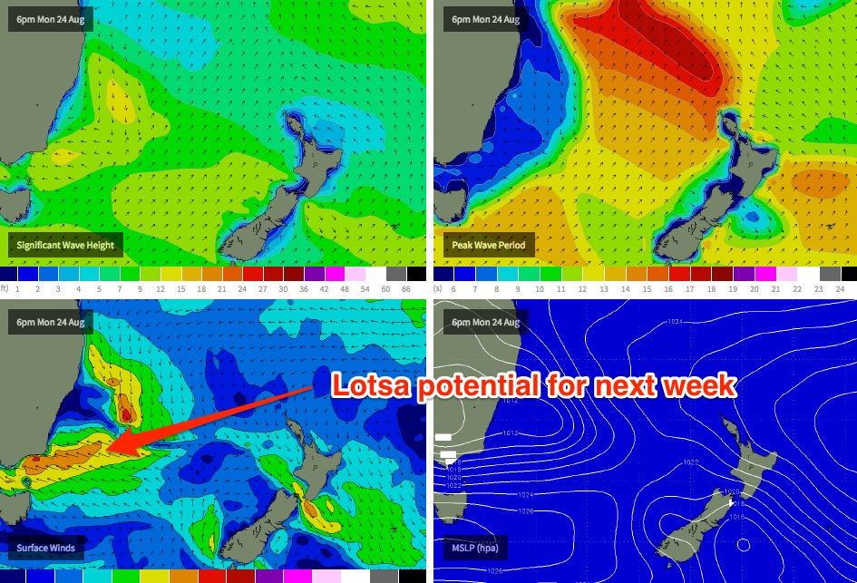
We’ve got an interesting pattern developing on the synoptic charts for next week. A broad trough developing across the eastern states will maintain a northerly flow off the Mid North Coast that could continue to supply the region with small peaky NE windswell for a few days.
However, of much greater interest is the cradling effects of a low latitude high pressure system (south of the trough) that is currently modelled to develop a broad E/SE fetch aimed into the South Coast around Monday (see chart below)
Whilst it’s still early days, it appears that this pattern will remain slow moving and could result in an excellent short range SE swell event developing early/mid next week and persisting for a few days.
There’s still a lot of flexibility required around this outlook though - mainly due to the close proximity of this system to the coast - and there’s also a chance that the fetch could re-align down towards the Far South Coast and/or Tasmania (i.e. outside of our swell window). But right now there’s enough potential to get moderately excited about, as these kinds of patterns (when they occur) often produce excellent waves across a reasonably broad swathe of the coast.
The long range charts also have a couple of deep Southern Ocean lows expected to push through our far southern swell window later in the forecast period, but this is fairly standard for this time of year so we don’t need to evaluate any more closely than this for a few days yet. More on all of the above on Friday.
Comments
Still a few decent sets at Bondi this arvo.
The new S'ly groundswell due to arrive in Sydney this evening has already reached Tasmania's East Coast and South Arm. Nice to have some confirmation - should be good across the Sydney region tomorrow morning, although the Far South and South Coasts should see this new swell arriving after lunch (still don't think it'll reach Sydney until after dinner time, however with the Eden and Batemans buoys adrift we can't confirm the leading edge until Pt Kembla!).
https://www.swellnet.com/reports/australia/tasmania/st-helens
https://www.swellnet.com/reports/australia/tasmania/south-arm
Think I counted about nine waves in this set. Swell is building nicely from the south, should reach a peak early arvo.
Yeah swell strong on the buoy now.. 16s.
wow, almost no change to height but the period has jumped and it's now pumping.
easy overhead faces on the sets.
Solid lines! Perfect southerly groundswell.