Extended period of small surf until Monday; large S'ly swell next week

Sydney, Hunter and Illawarra Surf Forecast by Ben Matson (issued Wednesday 22nd July)
Best Days: No great days. Minor E/NE swell Thurs/Fri with OK winds (best Fri) but it'll be small at best. A large S'ly swell is expected later Mon/Tues/Wed but local winds look tricky.
Recap: Tuesday morning delivered plenty of easing south swell, with early light winds creating clean conditions ahead of freshening N/NE winds in the afternoon. A new long period south swell was detected across many NSW buoy during the day, reaching Eden early morning, Port Kembla late afternoon, the Crowdy Head overnight - but the Sydney buoy didn’t pick up any energy (and there wasn’t much size in the water anyway, just some weak, residual 1-2ft waves this morning). However we’ve also seen a small NE windswell in the mix courtesy of the northerly flow that cropped up yesterday afternoon and overnight. Not many beaches saw size from this source but some Sydney NE swell magnets picked up occasional 2ft sets.
This week (July 23 - 24)
Only small surf is expected for the rest of the week, of which south facing beaches - for the first time in quite a while - will end up seeing the smaller end of the size spectrum. This will mainly affect locations like Cronulla, Bondi and the Northern Hunter.
A large high in the eastern Tasman Sea has two separate fetches, each of which will supply small surf to the region for the next few days. A small northerly airstream running along the Southern NSW coast is the first (and current) source, the other is a disjointed E’ly tending E/NE fetch in the Central/Northern Tasman Sea, on the northern flank of the high.
Both swells should offer somewhere in the 1-2ft range on Thursday, however the local NE swell will ease Friday with the E/NE swell probably becoming more dominant. Swell magnets may rake in a few bigger sets at times.
As for local conditions, both days look reasonably good. Early offshore winds are expected on Thursday, and a weakening front pushing along the coast during the day probably won’t influence the Sydney region with any strength in the trailing winds, but they are likely to swing SW after lunch (and may tend S’ly along the South Coast with a little more strength). On Friday we’ll see NW winds redevelop with rapidly improving conditions. However, with only small surf (tiny in some regions due to the swell direction) it’s not worth getting too excited about.
This weekend (July 25 - 26)
The weekend looks very ordinary. We may see some trailing E/NE swell from the mid-late week fetch in the Northern Tasman, but I’ll be surprised if it’s much more than a lazy 1ft, possibly 2ft at the swell magnets on Saturday, and tiny elsewhere (especially south facing beaches). Sunday looks even smaller.
Additionally, a succession of strong fronts crossing the region will deliver gusty offshore winds both days, which will probably knock the top of the small, short period energy. So, don’t be surprised if it’s even smaller than the heights stated above.
At this stage the fetch existing eastern Bass Strait - one of my favourite sneaky south swell windows - during Saturday’s frontal passage looks like it’ll be too west in direction to generate any notable south swell. A late pulse of energy in the 1ft range at south swell magnets on Saturday afternoon (a smidgen bigger in the Hunter) is possible, but honestly - you’re not going to plan your weekend around a meagre swell event like that, are you?
Let’s check back on Friday to see if there’s been any improvement in the model data. It can’t be ruled out right now, but it’s highly unlikely.
Next week (July 27 - 28)
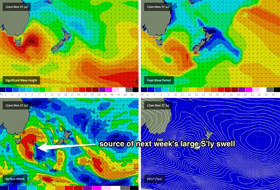
The second front/low combo on target for this weekend (on Sunday) looks like it’ll line up really well within our south swell window overnight and into Monday morning (see chart below). This will set up a large southerly swell to build across the region during Monday afternoon, with strong to gale force SW winds accompanying.
Additionally, a secondary low is expected to form east of Tasmania, and track northeast - this should maintain strong southerly swell through into Tuesday although may also veer the wind more southerly in direction at times.
As for size, Monday morning will probably end up starting off small but should be quite big by the afternoon (6ft+ south facing beaches). Tuesday looks like it’ll be in a similar size range - if not a shade bigger (6-8ft) - but local winds could create some problems.
Strong southerly swell will probably then continue through Wednesday before easing throughout the rest of the week. There’s a suggestion that we’ll see another strong series of fronts push through the swell window mid-late week (renewing strong southerly swell for the end of the week), but this is still quite some time away and will require further scrutiny in upcoming forecast notes.
Comments
+360hrs long way away is there any potential or is it to brief to confirm?
Too far out Jack.
Looks are deceiving at Cronulla Point!