Easing southerly swell all week

Sydney, Hunter and Illawarra Surf Forecast by Ben Matson (issued Monday 22nd June)
Best Days: Tues: easing S'ly swell with early NW tending N'ly winds. Sun: small S'ly swell with light winds.
Recap: There were plenty of waves over the weekend, with an easing S/SE swell offering strong sets Saturday (3-5ft most open beaches) and a fresh S’ly groundswell padding out Sunday (3-4ft Sydney’s south facing beaches, bigger in the Hunter). A second pulse of southerly swell pushed through this morning, a little smaller than Sunday but still offer good 3ft waves across Sydney’s south facing beaches, with bigger surf in the Hunter. Conditions were reasonably clean on Saturday and very clean through Sunday and today.
This week (June 23 - 26)
A strong ridge of high pressure across the Tasman Sea and an approaching series of fronts from the west will freshen northerly winds about the Southern NSW coast on Tuesday, before winds swing more north-west on Wednesday. The fetch alignment isn’t ideal for local swell generation, so we’ll be relying on easing southerly swell to keep the coast flush with surf potential.
Unfortunately, we’re on the backside of the current event so it’s only going to get smaller from here on. South facing beaches in Sydney should still have 2ft+ sets early Tuesday morning, with bigger surf likely in the Hunter near 3ft+, but expect the sets to be very inconsistent and smaller surf will trend throughout the day.
Conditions should be OK on Tuesday with early NW winds ahead of the developing N’ly flow but once it swings, I don’t think it’ll get too strong. In any case, northern corners will pick up the biggest waves and will offer the best conditions. It’ll be even smaller on Wednesday but south swell magnets should still have a few small waves to ride.
Unfortunately, the outlook for the rest of the week is pretty grim, mainly thanks to the current high pressure ridge across the Tasman Sea, which is steering all frontal activity to the south, and away from our southern swell window.
We’ve got nothing new expected for Thursday - just tiny residual surf at exposed beaches, under an initial W’ly tending SW then maybe S’ly flow (especially in the south) as a weak trough pushes off the coast. The southerly airstream in the wake of the trough will kick up a small low quality windswell for south facing beaches on Friday but no major size is expected - maybe some 2-3ft sets at south facing beaches - and winds will probably remain some form of southerly (maybe a few isolated pockets of SW, such as the Northern Beaches).
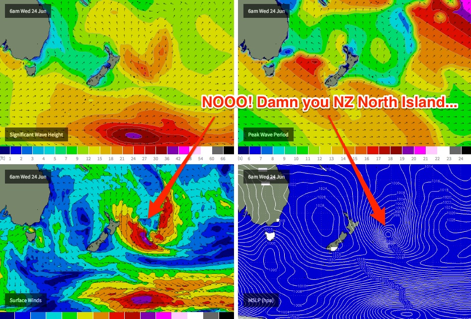
And in a double blow for East Coast surfers, the east swell mentioned in last Friday’s notes for this coming Friday has also been wiped off the charts. The responsible low pressure system is still expected to form (with considerable strength too), except the models now have it developing further SE than initially though (see chart below), which is now tucked inside the swell shadow of New Zealand’s North Island.
Interestingly, our surf forecast model is still picking up a small new E’ly swell on Friday (2ft sets), although I can’t quite see where this is originating from. It may possibly be from a related E’ly fetch momentarily pushing west of NZ’s North Island over the coming days, although the duration and strength doesn’t justify the predicted swell periods (almost 10 seconds) or the swell size (around 1m).
In any case I’d keep any expectations of an east swell very low for Friday. I should be able to quash (or reinstate!) this in more detail in Wednesday’s notes.
This weekend (June 27 - 28)
Looks like we’ve got a weekend of small surf on offer. Friday’s meagre southerly windswell will ease in size, and any of the small modelled east swell (if it arrives.. I’m not confident) will also be trending downwards. So it'll be very small to start the weekend.
A moderate front slipping below Tasmania on Friday night may kick up a minor southerly swell for Sunday, but probably no more than an inconsistent 2ft+ across most out facing beaches, and perhaps a few bigger waves in the Hunter.
Conditions look good both days but right now you’re more likely to be breaking out the fishing rod than the surfboard. Keep your expectations low and certainly don’t plan for any prolonged surf time just yet. Hopefully Wednesday’s model update will swing back in our favour.
Next week (June 29 onwards)
We’re looking at a steady stream of vigorous, powerful frontal systems below the southern Tasman Sea from the weekend onwards (all related to the same progression of weather systems delivering the big WA/SA swells later this week) and they’re going to provide as series of strong, long period, albeit small to moderately sized southerly groundswells for next week.
The first front is due to pass south of Tasmania late Saturday, and should provide a new south swell for Monday around 3ft+ at south facing beaches in Sydney, but up to 4-5ft+ across the Hunter coast.
Secondary fronts trailing behind should maintain a similar level of southerly energy through Tuesday and Wednesday, although the size and timing of each pulse is still a long way away from having any confidence in. Let’s take a closer look on Wednesday.
Comments
Which bloody boatie is docking on the buoy again!