South swell a'plenty for Southern NSW

Sydney, Hunter and Illawarra Surf Forecast by Ben Matson (issued Wednesday 10th June)
Best Days: Thurs: good S'ly swell with rapidly improving conditions as winds become light and variable. Fri/Sat/Sun: fun pulsey S’ly swells with light winds. Mon: new pulse of S/SE swell with generally light winds.
Recap: Near-flat conditions Tuesday. A new south swell has started building across Southern NSW this afternoon, with early 3ft sets at south facing beaches now pushing 4ft and expected to be a little bigger by later today. Winds have been mainly moderate S’ly although periods of W/SW winds have been reported about the coast.
This week (June 11 - 12)
The frontal progression responsible for the current south swell tracked a little off axis compared to Monday’s model guidance, which has resulted in a slight downgrade for Thursday.
Nevertheless, we’re still looking at a strong secondary pulse of south swell holding steady for much of the day, with south facing beaches likely to reach 4-5ft (bigger 6ft+ sets in the Hunter). Expect smaller surf at beaches not open to the south.
Local winds should become light and variable on Thursday as a weak high pressure system pushes across the south-western Tasman Sea, however there may be a lingering SE flow across the Hunter. For what its worth, model guidance also has a brief restrengthening S/SW flow across the Sydney/Illawarra coasts through the morning but I don’t think this will eventuate. For the most part conditions should be reasonably good across most of the Southern NSW coast, especially in the south.
On Friday, the south swell will slowly trend downwards. However, a succession of trailing fronts through the lower Tasman Sea will maintain plenty of background southerly swell energy, that should slow the easing trend. As such, south facing beaches should see inconsistent 3ft+ sets (smaller elsewhere, but bigger in the Hunter) and light variable winds - mainly W’ly - should keep conditions nice and clean. Smaller surf is likely through the afternoon as wave energy continues to subside.
This weekend (June 13 - 14)
A strong front within this recent progression, passing east of Tasmania on Thursday, will deliver a renewal of south swell that's due to arrive on Saturday morning. It’ll display longer swell periods (due to stronger core wind speeds) however the less-favourable storm track means swell size will be smaller across the NSW coast.
That being said, with light variable winds on offer all day conditions should be nice and clean. South facing beaches should build all day with sets in the 3ft+ range at south facing beaches by lunchtime, and bigger 4-5ft sets across the Hunter Coast. As per usual, expect smaller surf at beaches not open to the south. The timing on this pulse isn't clear so dawn may reveal smaller waves ahead of its arrival.
Sunday will then see this south swell ease slowly in size, but Sydney’s south facing beaches should again pick up fun 2-3ft surf, with bigger 4ft waves across the Hunter coast (ahead of an easing trend into the afternoon). Light winds are expected throughout the day once again thanks to the presence of a weak high across the Southern Tasman Sea.
Next week (June 15 onwards)
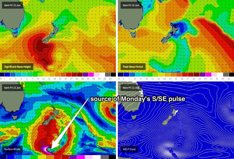
The front and low responsible for Saturday’s pulse is expected to undergo a further re-intensification, well to the south of New Zealand on Friday (see chart below). As this happens, a fetch of storm force S’ly winds are expected to wrap around the primary low, and should kick up a new long period S/SE swell that’s currently modelled to arrive mid-late morning on Monday.
Prior to the arrival of the new swell (early Monday), we’re looking at smaller residual southerly energy across much of Southern NSW. This new pulse of groundswell should however bring some strong sets to exposed regions throughout the afternoon, possibly between 3ft and maybe even 5ft, holding into Tuesday morning too.
Local winds look reasonably good at this stage - only light in strength - however a broad, weak front to the south may instigate a southerly regime across the region on Monday, before the synoptic flow swings NE on Tuesday. I’ll reevaluate this in more dateline Friday - but nevertheless it looks like a good swell event for the region.
Following this, it looks like the middle of next week will see a series of smaller S/SE swells originating from trailing fronts skirting the far eastern waters of the Tasman Sea, right along the West Coast of New Zealand’s South Island.
The other main feature for the longer term is a deepening trough across the eastern states from Tuesday through Wednesday which should strengthening NE winds about the coast, and kick up a generous short range NE windswell, probably somewhere in the 3-4ft range through Wednesday. However surface conditions will probably be quite average at first with the accompanying nor’east airstream.
What we’ll be looking for during this period is the timing for the trough to move offshore and local winds to swing around to the west, just as the swell starts to decline. At this stage it’ll probably occur somewhere around Thursday but I’ll take a closer look at this in Friday's notes.
Comments
2-3 ft crud if your lucky up north of newy today, is the swell a no show? Or late/ wrong direction?