Small surf mid-week; onshore and solid from Friday onwards

Sydney, Hunter and Illawarra Surf Forecast by Ben Matson (issued Monday 18th May)
Best Days: Tues/Wed: small clean south swell at exposed beaches.
Recap: Large S’ly swell on Saturday with variable winds, mainly onshore although periods of offshore winds were observed at times. The Hunter coast saw 6-8ft sets, with 4-6ft waves on the Northern Beaches and further south along the coast. This swell eased into Sunday by a couple of feet and winds remained favourably light and variable. A further drop occurred into this morning and conditions have been glassy for much of the day.
This week (May 19 - 22)
Not much in the size department for the next few days. We’ve got a large high pressure system in the Tasman Sea, and it’s currently steering frontal systems away from our near swell window. Several small southerly groundswells will push through over the coming days, generated by intense low polar lows (and their associated fronts) traversing our far southern swell window.
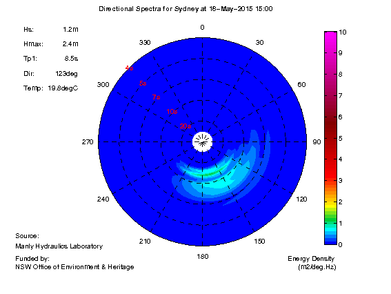
The first of these swells seems to have arrived in Sydney this afternoon (as per spectral data from the Sydney buoy, see below), and set waves are holding in the 2ft range at south facing beaches. The next pulse is expected to arrive on Tuesday, although there’s not much confidence on the timing - there may be a lag on its arrival early morning but we should see set waves pushing somewhere between 2ft and nearly 3ft at south facing beaches in Sydney during the day (a little bigger in the Hunter). Don’t be surprised if we don’t see the upper end of this size range until after lunch. However keep in mind that set waves will be very inconsistent, owing to the distant swell source, and it'll be much smaller at beaches not open to the south.
Northerly winds will freshen during the day and may cause some problems at some beaches. We’re looking at early nor’westers though so the morning should offer the cleanest conditions. Once these northerlies pick up you’ll have to duck into a protected northern corner (however, for the most part I reckon it’ll hang just north-west of north, which should be manageable).
Tuesday’s south swell will then ease slowly through Wednesday. Winds will veer back to the NW so conditions should be nice and clean but with very inconsistent set waves (and a dropping swell) you’ll really have to be quite patient to score the best surf.
On Wednesday night, a cold front is expected to push up the coast, forming a small low pressure system offshore from the Illawarra coast during Thursday. Right now the models are split on just how intense this low will be (and when precisely it’ll intensify) - the European solution is deepening it significantly early morning, forming a large Tasman Low with SE gales feeding into most of southern NSW.
However my feeling is that the GFS solution is more plausible, with a broad, more slowly developing trough encompassing most of the region on Thursday, and a strong SE fetch on its southern flank slowly moving into our swell window during the day. This will probably result in little to no new swell for Thursday, however we’ll have to re-evaluate this in Wednesday’s model runs in case they speed up its passage.
The low is then likely to deepen further into Friday - well offshore from the coast - but driving strong SE winds across the region to finish the week. It’s likely that we’ll see early SW winds in most regions north of Wollongong (the sou’easters will kick in much easier along the Far South Coast) however this window of cleaner conditions will probably be accompanied with smaller surf. Once the wind veers onshore, surf size will build rapidly (4-5ft by the end of the day) but it’ll be terrible on the surface.
Anyway, this is all a little up in the air for now but it’s certainly looking like a wet, windy Friday ahead with building onshore surf.
This weekend (May 23-24)
The weekend’s surf prospects will really hinge around this Tasman Low, and how it behaves on Friday. Current indications are that SE winds will persist through Saturday before easing into Sunday, so right now it’s not looking terribly flash on the surface.
As for surf, as well as a junky short range (and easing) SE swell originating from the local fetch, we’ll also see some southerly groundswell from a deep Southern Ocean low that’s expected to track NE towards the southern Tasman Sea overnight on Wednesday. This swell should be in the water on Saturday morning but probably won’t be any bigger than the pre-existing SE energy (say, 3-5ft south facing beaches). And in any case it’ll be bumpy to boot.
Further fronts in the Southern Ocean look like they’ll be less favourably aimed for Southern NSW, so we’re looking at smaller southerly swell for Sunday with easing SE energy too. However conditions should slowly be improving by this time. Keep your expectations low and hopefully we’ll see a model improvement by Wednesday.
Next week (May 25 onwards)
Looks like we’ve got a long period south swell lining up for early next week, originating from a deep polar low that’s expected to form off the ice shelf on Friday, due south of Tasmania.
Current expectations are that it’ll be much better aimed towards New Zealand and Fiji however we should see some quality sideband energy push through Monday that should provide occasional 3-5ft sets at south facing beaches. I’ll revise this in more detail on Wednesday.
Comments
Hi Ben, re the next couple of days - I see this occasionally - from such a long range source, why are sets larger in the Hunter than Sydney...refraction?
Couple of factors - the local bathymetry, plus the slight eastward curve of the Hunter region means it faces SE, which allows it to rake in more southerly energy than the coastline to the south (which mainly faces E/SE).
I'd add geography in combination with it being SE facing. The eastward curve that Ben mentions also means that the Hunter simply sticks out further to the east. As such it is better aligned for those S or especially slightly West of S swells which can largely go past Sydney.
Yeah that's what I meant (re: geography). The further east you move along the Hunter curve, the more south swell it picks up.