Ordinary weekend; but there's potential from next Friday onwards

Sydney, Hunter and Illawarra Surf Forecast by Ben Matson (issued Friday 20th March)
Best Days: No great days due to poor winds and/or low swells. Wednesday morning probably the pick with an early peak in new south swell and (hopefully) early light winds.
Recap: Small leftovers on Thursday with abating S/SW winds tending light SW, then variable ahead of an afternoon sea breezes. Wave heights became tiny this morning ahead of a gusty southerly change and a late building southerly windswell this afternoon.
This weekend (Mar 21 - 22)
We’ve been spoilt of late, so the weekend looks pretty ordinary for most surfers.
Still, there’ll be waves around. A ridge building in behind today’s change will drive fresh south-easterly winds into most locations on Saturday (a little lighter in the Far South) so conditions will be choppy just about everywhere. We’ll see around 3ft+ of peaky short range surf but don’t expect any quality.
On Sunday, winds will veer around to the east as a high in the southern Tasman slides slowly eastwards. This won’t improve surface conditions anywhere except the Far South Coast (which may see light and variable winds up as far north as about Ulladulla), and surf size will throttle back a touch, probably still in the 2-3ft range but likely to be very low in quality.
So there you have it! Plenty of surf this weekend but nothing worthwhile.
Next week (Mar 23 onwards)
Still looking average for much of next week.
Light winds on Monday morning will precede a freshening nor’easter ahead of a southerly change due in sometime around lunch or early afternoon on Tuesday (in Sydney, earlier on the South Coast).
At this stage Monday will see small residual energy from the weekend (a couple of feet, remaining low in quality) but there’ll be a few options if you’re desperate.
Smaller surf will pad out Tuesday morning ahead of the change but the afternoon should see a late, rapid increase in low quality southerly windswell, possibly 3-4ft at south facing beaches.
Rapidly easing winds are then expected on Wednesday with slowly easing southerly swell. At this stage Wednesday morning is probably the pick of the forecast period with possibly 3ft+ of south swell at exposed south facing beaches early (maybe some bombs in the Hunter) but with an expected easing trend throughout the day.
Over the last week or so I’ve mentioned another possible tropical system way out near Fiji for the weekend that could provide something beneficial later next week. The low is still expected to develop but the latest model guidance now has it developing off-axis to the southern NSW region, which reduces its swell potential a little. Still, we should see a slow building, long-lasting trend through the second half of next week and into the weekend, set waves possibly in the 2ft+ range but likely to be very inconsistent. I wouldn’t rely on it as a notable swell source at this stage.
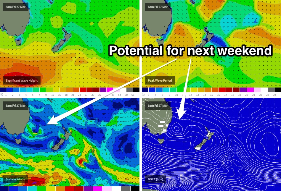
Otherwise, the models also are suggesting we’ll see a cut-off low in the southern Tasman Sea later next week (around Friday), which may end up being a significant source of swell for the southern NSW coast into next weekend.
This is probably the weather system to focus your long term plans around right now as there’s a good chance we’ll a synoptic break in the current blocking pattern that’s maintaining small swells across our region. I’m quietly confident that this will end up being a sizeable swell event, albeit out of the southern quadrant (which can limit options on some coasts).
‘Till then, have a great weekend!