More strong swell from the south

Sydney, Hunter and Illawarra Surf Forecast by Ben Matson (issued Friday 30th January)
Best Days: Sat/Sun: strong S'ly swell with good winds (esp north of Wollongong, and in the mornings). Mon/Tues/Wed: varying degress of moderate south swell, but with tricky winds (early mornings should be OK). Later next week and into the weekend: chance for some cyclone swell.
Recap: Moderate but punchy SE swell Thurs with generally fresh SW tending S’ly winds (although W/SW for a brief period in a few areas) ahead of a building S’ly swell today that reached 6-8ft at most beaches and up to 8-10ft at some exposed coasts. Winds were W’ly early morning at a lot of locations but swung SW then S’ly from mid-late morning (winds are even SE on the Central and Hunter Coasts). Lots of fantastic big waves reported at many spots (this swell was first discussed in last Wednesday's notes).
This weekend (Jan 31 - Feb 1)
The low responsible for today’s large swell has fully matured, or in other words reached a peak in intensity - however it’s expected to remain very slow moving in the south-western Tasman Sea for the next twenty four hours, before slowly moving eastwards towards New Zealand.
What this means is that we can expect Saturday to see another day of large waves. However, there will be a few key differences to what we saw today: with the low a little closer to the mainland that it was on Thursday, and with the SE fetch on its southern flank starting to weaken, this will leave the primary fetch as being straight southerly, almost parallel with the coast.
So today we’ve seen a reasonable amount of SE in the swell direction but it’ll swing more southerly tomorrow. This will create a greater range in wave heights between exposed and protected spots than what we saw today.
Furthermore, as the low gradually weakens whilst it slips slightly to the south and then slowly begins an eastward track, it’ll have a much lesser influence on local winds.
The Far South and South Coasts should still see fresh and gusty SW tending S/SW winds on Saturday, but north from Wollongong to Seal Rocks will have lighter W/SW winds and sea breezes. A further reduction in wind strength (across the same areas) is expected on Sunday.
As for size - Saturday should still be some rogue 6ft to maybe 8ft sets at exposed south facing beaches, particularly in the Hunter region, with smaller waves of 3-5ft at most open beaches and 2-3ft inside sheltered southern corners. On Sunday expect a drop in size within the order of a couple of feet, so up to 4-6ft at exposed south facing beaches with smaller surf elsewhere.
Next week (Feb 2 onwards)
A very slow easing trend from the south is expected on Monday, in fact south facing beaches could still very well be 4-5ft early morning (smaller elsewhere).
However, the wind outlook is dicey with a ridge expected to build along the NSW coast, which may bring about moderate to fresh SE winds. Early morning will offer the best chance for a window of clean conditions. An easing trend is expected through the afternoon and into Tuesday.
Reasonable frontal activity below Tasmania on Sunday and Monday will kick up a fun new south later Tuesday (in the south) and early Wednesday (say, 2-3ft+ sets south facing beaches), however a much stronger front will push through the southern Tasman Sea at around the same time, generating a bigger, stronger south swell for Thursday morning, in the 3-5ft range at south facing beaches.
Whilst all of this is going on, there are likely to be some significant developments occurring in the Coral Sea. A small tropical low is current positioned northwest of New Caledonia, and the latest model guidance has it tracking due south and into the Northern Tasman Sea, whilst intensifying rapidly.
Although it’s acknowledged that this swell window has been somewhat of a disappointment so far this (cyclone) season, there is very good agreement between the models that (1) we’ll see the development of a significant Tropical Cyclone sometime early next week, and (2) it’ll stay within the longitudinal confines of 165E and the mainland (i.e. won’t be whisked over to the east).
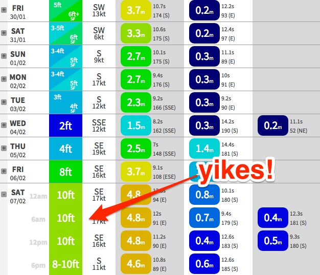
What this means is that we are once again on standby for a solid north-east groundswell from mid-next week onwards. Some models - including the one driving our surf model forecast - have it developing much earlier than the others, suggesting a small NE swell around Wednesday or Thursday followed by a large swell late Friday or over the weekend (our model is currently gunning for 10ft from the east on Saturday! see chart below).
Gut feel is that we probably won’t see any appreciable new swell until the end of the week or the weekend, and that it’ll be a reasonably strong event however with some north in direction - which could create some problems for locations in the lee of the Hunter curve (due to the swell shadow). However all of this is speculation until the cyclone actually develops, so I’ll review the situation in more detail on Monday (nevertheless I'm gearing up for some solid waves out of the north-east for the long term).
Have a great weekend!
Comments
with a forecast like that, ya wouldn't be dead for quids!
Frothing to be home!!