Average on the whole, but plenty of options

Sydney, Hunter and Illawarra Surf Forecast by Ben Matson (issued Wednesday 29th October)
Best Days: Late Friday: new long period S'ly swell with NE winds. Saturday: peaky combo of NE and easing S'ly swell with NW winds.
Recap: Fun clean south swell Tuesday morning with early light offshore winds that persisted all day in some locations. A marginally smaller but noticeably weaker round of south swell filled out exposed beaches this morning, with early light winds ahead of a freshening E’ly breeze into the afternoon and a building south swell that’s currently in the 4ft+ range and should increase further through until dark.
This week (Oct 30-31)
Today’s building south swell will be a short lived affair, peaking overnight and easing through the early hours of Thursday morning before continuing the downwards trend during the day. We should still see a few 3ft+ sets at exposed south facing beaches at dawn (smaller at remaining beaches, but bigger in the Hunter), however it’ll tail off steadily during the day.
The main concern with Thursday are the local winds. The existing E’ly flow is expected to swing NE overnight, but then back off temporarily for a few hours early morning. There’s a small chance that we’ll see a swing towards the N/NW within an hour or two of first light, but I’m not confident that it’ll happen at many locations - and even if it does, it probably won’t be enough to iron out the lumps and bumps from today’s airstream.
So expect conditions to generally be below par (fortunately, it’ll be cleanest inside northern corners which will also be the most protected spots). Freshening NE winds will then resume through the middle of the day and the afternoon.
On Friday we’re looking at small residual energy for the first half of the day. A shallow southerly change is expected to push across the region in the early hours of the morning, and may linger through the dawn session; if this happens conditions won’t be great at exposed south facing beaches. However, these winds are expected to relax pretty quickly throughout the morning and should trend light SW up until about lunchtime, before swinging NE into the afternoon and freshening late in the day.
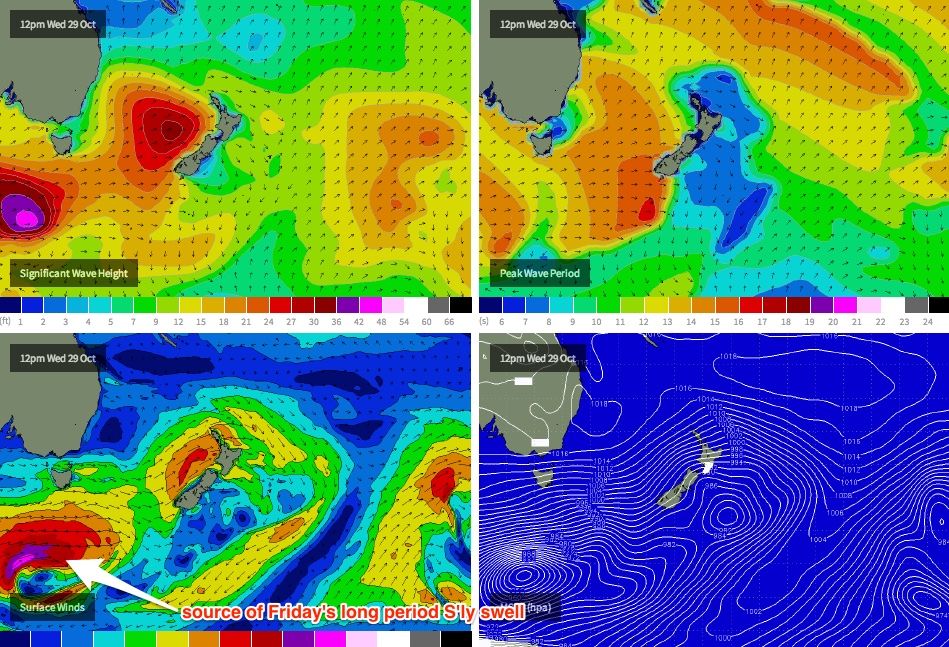
At the same time, a very long period south swell - generated by an intense polar low travelling south of the continent mid-week - is expected to track along the southern NSW coast, displaying swell periods in the 19-20 second range. This system hasn’t lined up very well in our swell window (see chart below), and based on the performance of today’s southerly swell (running late, a shade smaller than expected), I’m going to pull back the predicted size range a smidge - we should see long period energy kicking up around late morning, with an upwards trend through the afternoon that should deliver inconsistent 3ft+ sets to most south facing beaches by the end of the day (the Hunter should see much bigger waves between 4ft and maybe even 6ft).
So, the late session is potentially looking pretty good if you’ve got a south friendly spot that enjoys long period south swells with freshening NE winds.
This weekend (Nov 1-2)
Friday’s south swell will peak overnight and trend downwards through Saturday. However we’ll also see some NE windswell in the water early morning from the fetch developing late Friday; exposed beaches should see a peaky combo in the 2ft to almost 3ft range (another foot or more bigger in the Hunter) and winds are expected to freshen from the NW as a southerly change approaches the South Coast; due into Sydney overnight Saturday. So aim for an exposed beach and make it early before the swell loses any more size.
Saturday night's southerly change looks like it’ll whip up 3ft+ of peaky swell for exposed south facing beaches on Sunday, but lingering onshore winds may take the sheen off conditions. They should moderate through the morning before freshening from the east into the afternoon, so keep your expectations low - but there’ll be waves all day if you don’t mind the bumps.
Long term (Nov 1 onwards)
Another strong front pushing through the lower Tasman Sea on Sunday will maintain moderate southerly swell into Monday, before a trough pattern redevelops across the coast through Tuesday, spinning up another local NE fetch that should contribute peaky short range energy for several days through the middle of the week as a minimum. I’ll have more on the specifics in Friday’s update.
Comments
Interesting - the BOM's 4pm report didn't have Friday'e early (1am) S'ly change. Will be interesting to see what eventuates.
Thursday 30 October: Winds: North to northeasterly 15 to 20 knots.
Friday 31 October: Winds: Northerly 15 to 20 knots tending northeasterly 15 to 25 knots in the early afternoon then tending north to northeasterly 20 to 30 knots in the late evening.
Decent sized sets at Bondi for the late session.
Spring in Sydney south east, north east, south east, north east, neither with quite enough intensity to amount to much before disappearing into the next wind change.
The buoy is back and looks like it is working
http://new.mhl.nsw.gov.au/data/realtime/wave/Station-sydney
Hmmm. One data reading from 7am. It's a start!
Was in the water yesterday arvo till close to dusk and it really didn't hit except for the very rare one. This morning was quite a different story though, lot of energy in the water, even if a little unruly.
Almost dead south on the spectra.
Can't see any southerly change for tomorrow morning Ben. Seems to no longer exist. Don't mind the wind direction for where I'm planning tomorrow, just need some of that long range swell to fill in.
There were some bombs for the last hour......where we you batfink???
Hey Mick, check this: http://www.southwave.com.au/feature-view/daily-snapshot-thu-30th-oct/#!prettyPhoto
Bastard
It's only a shallow S'ly change on the models BF - reaching Cronulla around 1-2am and the Northern Beaches around 3-4am - but only 10-15kts. Should be enough to disrupt the northerly regime anyway (which'll kick in during the afternoon and become quite gusty later).
You can see it in the latest chart here for 5am Friday morning.
Yep BB and Ben, Sydney buoy back and running.
Only a week or two without it, but jeez it was a long one!
Lots of new lines pushing through with 3ft+ sets at Bondi in the last little while: this seems to be the long period south swell. You can see overlapping swell trains too which is a giveaway.