Lots of swell sources for the region

Sydney, Hunter and Illawarra Surf Forecast by Ben Matson (issued Friday 4th June)
Best Days: Sat/Sun: small mix of south swells with good winds. Mon/Tues/Wed: fun SE swells with generally good winds. Thurs/Fri: chance for a solid E/SE groundswell.
Recap: Plenty of fun surf from the south over the last few days. Again, Thursday morning was a little smaller than the afternoon which saw a small pulse of energy across the region (swell periods at the Sydney buoy remained flat but swell heights increased by almost half a metre). More interestingly, a scan of our Sydney surf cams this morning shows 2-3ft sets at south facing beaches, even though it was only just capping out at 2ft this morning. And that’s despite a downwards trend at the buoy all day (as yet, there’s no sign of the small new S/SE swell expected very late today). Clean conditions overall with offshore winds Thursday and this morning, tending light N’ly this afternoon.
This weekend (July 5-6)
We’ve got a couple of remote sources of swell for the weekend, which should ensure small but fun, rideable waves at south facing beaches.
A small cut off low formed well south of New Zealand during the middle of the week, and merged with the fronts responsible for our most recent southerly swells. This low developed a tight S/SE fetch that generated a small new event that’s due to arrive over the coming hours, but will probably peak overnight before trending slowly downwards on Saturday. Set waves should manage 2ft+ at south facing beaches (maybe a few bigger waves in the Hunter) but there’ll be long breaks between waves, and moderate to fresh W/NW tending W’ly winds will keep conditions clean. Expect smaller surf into the afternoon.
Another small, flukey swell source is lining up for Sunday. A small but intense Southern Ocean low is tracking up through the southern Tasman Sea towards southern NZ, and while not very well aligned for the East Coast, it’ll generate some sideband energy that’s expected to glance the coast throughout the day.
This swell will probably be even less consistent than Saturday’s, but south facing beaches may again pick up some 2ft+ sets at times (as per usual, possibly a smudge bigger in the Hunter). Conditions will be clean with fresh W’ly tending W/SW winds. Don't be surprised if the dawn patrol is a little under spec too (should be in the water by mid-morning though).
Also expected late Sunday - but only relevant for the Far South of the state - is a new SE swell. This event will be generated by a stationary E/SE fetch which is modelled to develop east of Bass Strait over the weekend, in conjunction with a broad trough of low pressure across the southern Tasman Sea and a strong high pressure right to the south, at polar latitudes.
This (slightly unusual) synoptic setup will generate good waves for all of southern NSW on Monday but we may see the leading edge push through into the Far South late Sunday afternoon - and with fresh SW winds on hand there could be some good options at locations that pick up SE swell well but can handle this airstream. So if you're in that neck of the woods keep an eye on the coast after lunch.
Next week (July 7-11)
We’re finally seeing some consolidation in the model guidance, and next week’s looking very good for NSW surfers.
First up - the E/SE fetch east of Bass Strait over the weekend will kick up some good SE swell for much of the region on Monday. Set waves should reach somewhere in the 4ft range at most open south facing beaches by the afternoon (smaller at remaining beaches, and smaller early morning), however size will be a little bigger with increasing southerly latitude: the Far South could see 5-6ft+ sets from this source with an earlier peak in size. Moderate to fresh W/SW winds will keep conditions clean just about everywhere however winds will be stronger and more SW in the south as a low pressure system develops off the South Coast.
This swell is expected to ease slowly on Tuesday with improving conditions as local winds throttle back (there’ll still be very good surf at all open beaches) however a secondary, related fetch is modelled to have developed immediately west of Cook Strait on Monday that’ll generate a slightly smaller E/SE swell for Wednesday.
Guidance is a little split on whether this will be favourable for Sydney or not (the European model suggests the swell will be primarily focused towards Tasmania’s East Coast) but I think overall most beaches in southern NSW should see a pulse into the 2-3ft+ range throughout the day, with bigger waves on the South Coast. Freshening NW winds will again maintain clean conditions at most beaches. I’m not super confident on Wednesday's event though so let’s see how it’s looking in Monday’s update.
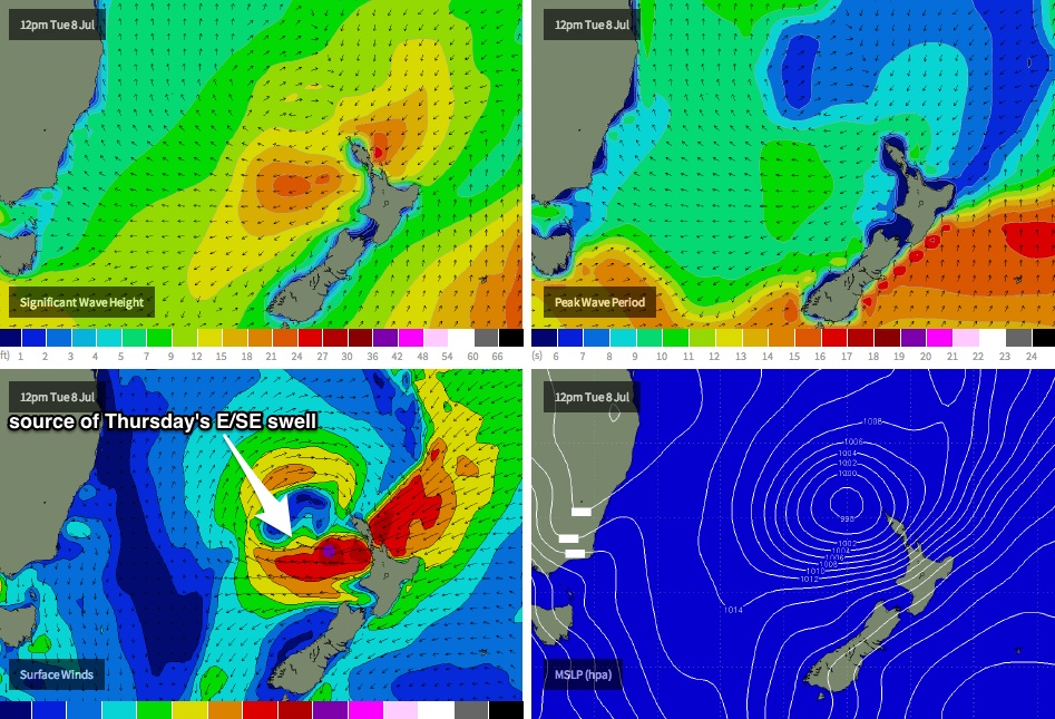
While all of this is going on, some tropical developments south of New Caledonia are expected to drift south towards New Zealand, consolidating with the broad system west of Cook Strait by Tuesday. This is expected to develop a powerful E’ly fetch and mid-week (see chart below) and a resulting strong E/SE groundswell that’s expected to arrive sometime around Thursday, with set waves in the 3-5ft range at most exposed southern NSW beaches, and bigger sets on the South Coast. This swell should dominate the coast through Friday but will probably be easing by this time.
It’s worth mentioning that I’m trying to find the line of best fit between the model guidance for this long range event, because the European model (which has been pretty consistent with this system over the last few days) suggests even bigger surf than what I’ve mentioned above. On the other hand, the other models are a little flakey. So let’s take a closer pass at this on Monday with the availability of updated model data. In any case, winds are looking really good as a deep low is expected to track through Bass Strait and will drive gusty W’ly winds across the region. So, chances are pretty good for a decent easterly swell with clean conditions.
Long term (July 12 onwards)
The low moving through Bass Strait mid-late next week looks like following a similar storm track to what we saw over the last few weeks. That is - quite north in latitude, meaning small, flukier activity within our less reliable south swell windows. Still, it’s looking like being an active period ahead so it looks like the weekend through early the following week will switch our focus back to the south. Have a great weekend!
Comments
The expected SE swell is now filling in nicely across Sydney beaches (although it's more S/SE in direction than was anticipated). Looks 3ft+ at Bondi and should get a little bigger into the afternoon. Had reports down south of solid 5-6ft waves this morning with perfect conditions.
Live vision from Bondi: https://www.swellnet.com/surfcams/bondi
Sets in the 4ft range at Bondi now.