Tiny weekend of waves; strong south swell next week

Sydney, Hunter and Illawarra Surf Forecast by Ben Matson (issued Friday 27th June)
Best Days: Mon/Tues/Wed/Thurs: strong S'ly groundswell, biggest Tues/Wed with generally good winds.
Recap: Pumping south swell on Thursday with a slight easing trend during the day (early 3ft sets at south facing beaches, bigger in the Hunter). A new south swell filled in overnight of a similar size, but will ease into the afternoon. Winds have been offshore both days with good conditions however N’ly winds may crop up this afternoon.
This weekend (June 28-29)
No changes to the weekend forecast. Our current south swell is expected to begin an easing trend this afternoon and this will continue through Saturday. With no new swell sources on the cards, we’ll have to make the most of what’s on offer early Saturday morning. By late afternoon or early Sunday morning it’s likely to be close to, if not completely flat; freshening NW tending W’ly winds will exacerbate the dropping swell situation.
So in short - aim for an early Saturday morning session and keep your expectations low for much of the weekend as we’ll be starting from a low base (given the current 2-3ft size at south facing beaches, which is expected to drop later today and overnight). However slightly bigger waves are expected in the Hunter early Saturday morning, which is undoubtably the pick of the forecast period.
Next week (June 30 - July 4)
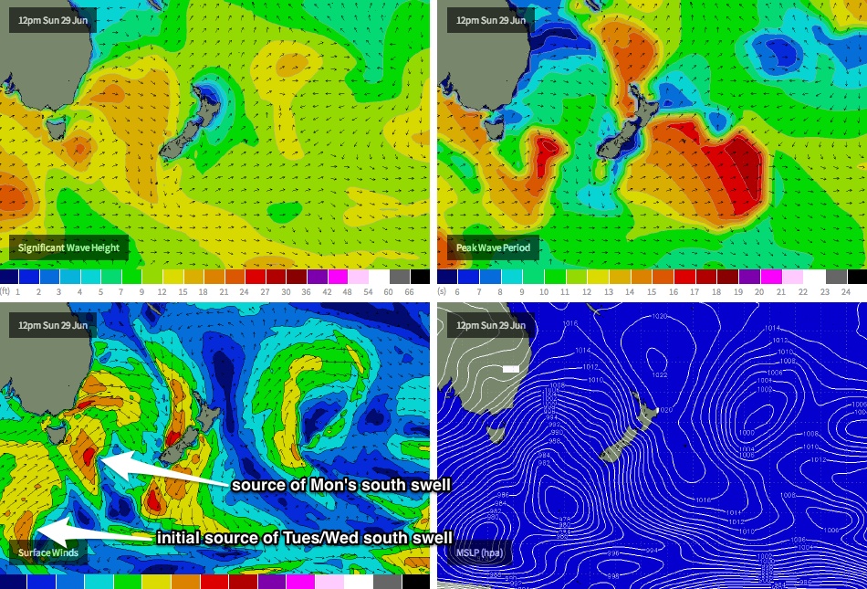
The Long Wave Trough is expected to amplify across Tasman and then New Zealand longitudes early-mid next week, and the upside of this is that its western flank should be positioned inside our southern swell window. This means that rather than having short-lived fetches within flukey parts of our swell window, we’ll have a much broader range of S/SW fetches working from polar latitudes right up into the southern Tasman Sea (see image below).
This is expected to result in around four days of strong southerly swell of varying size and quality, from Monday thru’ Thursday; even Friday should see some small trailing energy off the backside of this pattern. The only (slight) downside is that the overall wind regime will swing more to the SW (following on from morning W/SW winds at many locations), and there’s a risk that we’ll see some periods of S/SW winds (Tuesday afternoon looks to be the most likely day for this). However we should see plenty of size with some good refraction into sheltered spots.
Set waves should reach somewhere in the 5-6ft+ range at south facing beaches throughout this period, which may kick in as early as late Monday (there’ll be a strong upwards trend all day, but maximum surf size is more likely on Tuesday). Wednesday morning should also see plenty of size however a downwards trend is expected during the day. As per usual, expect smaller surf away from south facing beaches. And, the Hunter should see slightly bigger surf all days.
Overall, there’ll be plenty of waves from the south right throughout this period so you should be able to get some good rhythm from day to day.
Long term (July 5 onwards)
Nothing of significant beyond next week’s long spell of south swell, but I’m sure we’ll see something materialise by Monday’s updated forecast notes. ‘Till then enjoy the weekend and prepare for some good surf from Monday morning onwards.
Comments
Ben what wave size can we expect for tomorrow's dawn patrol sess. Cheers bro
thank God I have managed to scam a job where I can often finish work at lunch, before heading back for some evening office work.
Otherwise I wouldnt have surfed for about 3 weeks. weekends have been dismal lately.