Plenty of swell from the south

Sydney, Hunter and Illawarra Surf Forecast by Ben Matson (issued Monday 16th June)
Best Days: Tues: easing south swell with good winds early. Possible late increase. Wed: strong new south swell, but windy from the SW (maybe W/SW early). Thurs: easing S'ly swell, building later with a new pulse. Fri/Sat: good S'ly tending S/SE swell with offshore winds.
Recap: What a weekend, eh? Friday’s late E/SE groundswell eased slowly throughout Saturday but still offered 3-4ft sets at most beaches early morning, with a few bigger bombs in the Hunter, and conditions were clean with light offshore winds. Surf size was pretty small early Sunday (as expected) however a new south swell built slowly after lunchtime, rocketing up in the hour or so before dusk with south facing beaches pulling in 6ft+ sets right on dark (gusty W/SW tending SW winds kept conditions blustery). This strong south swell has held into this morning, generally around 6ft+ across south facing beaches of the the Sydney and Illawarra regions, but it’s much bigger in the Hunter (8ft+ at times). Conditions are really good with light W’ly winds.
This week (June 17-20)
No changes to the forecast for this week, as issued on Friday. This isn’t so much a point of internal gloating, but merely to highlight that the model data has been pretty consistent with its output over the last few weeks, which shows that our forecast system is working very well. The model nailed the weekend and Monday forecast and right now I can’t find any reasons to tweak the data up, down, forward or backward for the next few days.
So, the synoptic situation is as such: the Tasman Low responsible for our current swell is tracking towards New Zealand post-haste, and its swell source has long been shut off inside our swell window. So a rapid easing trend is expected into tomorrow. There’ll still be 3ft sets at south facing beaches early Tuesday morning (with bigger waves in the Hunter), however early fresh W/SW winds are expected to swing gusty SW then S/SW late in the day as a new front passes across the region, so the best conditions and biggest waves will be on offer at dawn.
A reasonable fetch associated with this front is expected to push along the coast late in the day that could very well provide a kick in new south swell in the hour or two before dark, however the most size is expected overnight and into Wednesday. South facing beaches should hold out somewhere in the 4-5ft range early Wednesday morning, and it’ll be bigger in the Hunter - but as per usual under these south swells, expect smaller surf at beaches not open to the south.
Winds may cause a few problems on Wednesday but in general we’re looking at a moderate to fresh SW flow tending S/SW during the day (some locations, such as the Northern Beaches may see a period of W/SW winds early morning). Surf size will then slowly ease into the afternoon.
Surf size will then fall back through Thursday morning (2-3ft south facing beaches), and conditions will improve pretty quickly as winds tend light W’ly, with possibly a late N/NW trend (mainly south of Sydney). Plenty of options across open beaches but protected locations will be pretty small by this time.
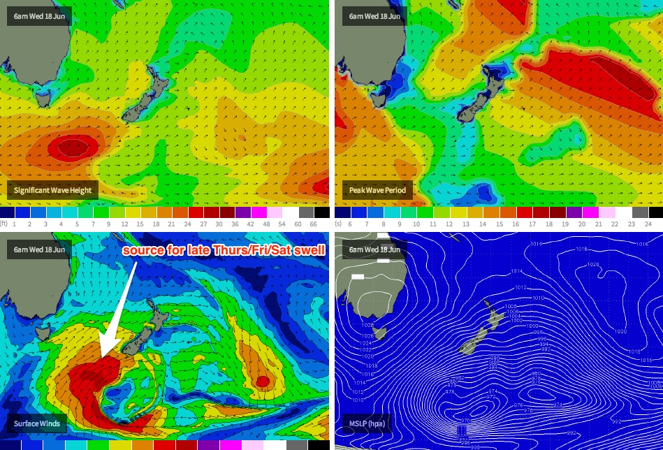
This is where things start to get interesting. A series of strong fronts traversing the Southern Ocean well to the south of Australia are expected to track NE below the Tasman Sea mid-week, on target for New Zealand. Although unfavourably aligned for Australia’s East Coast, they will generate a couple of good pulses of long range S’ly then S/SE swell for the region (see chart below). No major size is expected but with good winds on hand it’ll be worth sniffing out an open beach break. Our model isn’t picking up these swells very well so I’m going to go against the consensus and forecast above their computer-generated estimates.
The first pulse is due into the South Coast around late morning on Thursday and should arrive in Sydney mid-Thursday afternoon. So whilst surf size is likely to ease from the dawn session, keep an eye out for a late increase at south facing beaches (say, 2-3ft+ with long breaks between sets).
This south swell should fill through a little more convincingly through Friday - probably no more size but perhaps a little more consistency than late Thursday - and with freshening NW winds on offer most south facing beaches should be delivering some great waves.
This weekend (June 21-22)
On Saturday, another pulse of energy from this same system mentioned above is expected to arrive, and it’ll probably display the longest swell period of the lot. It’s forecast to be generated by a developing polar low that’s modelled to merge with the frontal system well to the south of New Zealand overnight on Wednesday and into Thursday morning, (and will probably be responsible for both a massive swell and a significant dump of snow in southern NZ!).
Anyway, this fetch is expected to kick up a decent S/SE swell that’s expected to push through on Saturday morning. Again, our wave model isn’t picking it up very well right now but I think we’ll see good 2-3ft waves at south facing beaches in Sydney, up to 3-4ft+ in the Hunter at times, although with long breaks between sets. Fresh W/NW winds will maintain great waves at most open beaches on Saturday however locations not completely open to the south will be smaller.
Slowly surf is then expected through Sunday and current indications are that a moderate SW tending S/SW airstream will sweep up the coast. We may see a small increase in locally generated south swell but at this stage there’s no indication of any major size or energy.
Long term (June 23 onwards)
Nothing major on the long term charts right now. If anything there’s a hint that we’ll see a similar progression of Southern Ocean fronts through next week, leading to a couple of pulse of moderate south swell with generally good winds - but I’ll have a closer look in Wednesday’s update.