Excellent waves expected later this week

Sydney, Hunter and Illawarra Surf Forecast by Ben Matson (issued Monday 9th June)
Best Days: Wed: new SE swell arriving late. Thurs: clean but easing SE swell. Fri: powerful E/SE groundswell with offshore winds. Sat: easing E/SE swell with early offshore winds. Sun: large S’ly swell, but windy. Mon: easing S/SE swell with improving conditions.
Recap: Wave heights have generally played out as expected over the last three days: peaky south swell early Saturday, easing during the day ahead of a rebuilding short range south swell throughout Sunday, followed by a stronger southerly groundswell this morning (set waves reaching 4-5ft at south facing beaches, bigger in the Hunter). Conditions were a little better than expected on Sunday morning though, with most locations picking up early offshore winds (rather than just a couple of locations, as had been expected). Fresh southerly winds are now across the region and surf quality is diminishing rapidly.
This week (June 10-13)
No major changes to the forecast issued on Friday. Today’s southerly groundswell will begin to ease later this afternoon, but it’ll be replaced by a new short range SE swell on Tuesday, courtesy of a building ridge across the coast that extends out into the central/southern Tasman Sea.
No signifciant size is expected from this source though, and winds will mainly be fresh out of the south-east, so conditions will be very ordinary at most locations. There's an outside chance for periods of lighter, more favourable winds at dawn in a few selected areas, but with a great forecast period ahead it's really just worth treating Tuesday as a lay day.
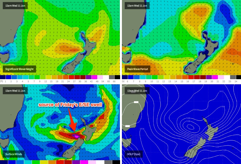
A complex, deep trough currently lies off the west coast of New Zealand, and it's expected to be an active source of swell for the entire NSW coastline for the rest of the forecast period. Right now a small S/SE fetch off the SW tip of New Zealand’s South Island is strengthening around a small centre of low pressure that's modeled to pinch off from the trough into Tuesday, tracking north-west into the central Tasman Sea. The computer models have slightly upgraded the strength of this fetch since Friday, but our wave model isn’t resolving it very well - so I’m going to call above the size currently listed on the graph (which is about 3ft).
However the tricky part about this anticipated swell is the timing - it’s forecast to arrive during Wednesday afternoon, and will probably peak overnight before easing throughout Thursday. With Wednesday afternoon’s winds looking a little suss north of about Wollongong (thanks to a lingering influence from the current ridge, which will be weakening by then), your best chance for a wave from this swell will be first thing Thursday morning.
However late Wednesday will probably have the most size (solid, well defined sets in the 3-5ft range straight out of the SE), with light to moderate S/SE winds keeping conditions just a little below par. So the surf should still be very good at those locations offering a small degree of protection from the wind. And the morning session won’t go unrewarded either, with a combo of pre-existing SE swells in the 3ft range likely to be accompanied by an early period of offshore winds across most parts of the coast.
As a side note: if you’re on the South Coast, conditions should be good here all day with light variable winds under the influence of a broadening high pressure system. So the late session should produce some gems south of Sydney/Wollongong.
On Thursday, there may be some early bombs in the 3-5ft range at most beaches but it’s likely to be trending downwards from the get go: conditions should be excellent though with light variable winds tending N/NW and freshening. Smaller but equally clean late afternoon, maybe some wobble developing at locations exposed to the north however northern corners should be great all day.
Friday still looks excellent. A cold front will be approaching the western parts of the state during this time, freshening winds from the north-west across the coast, and a solid new E/SE groundswell is expected to arrive mid-morning, building towards a peak in the afternoon. This swell will have originated from a secondary low forming within the trough off NZ’s West Coast later Tuesday and Wednesday, which is expected to exhibit a sustained fetch of 40kt+ E’ly winds west of Cook Strait.
Set waves should approach the 5-6ft+ range at exposed beaches and reefs during the afternoon, and it’ll be quite powerful too with a healthy wavelength/swell period (although there may be a wait for the bigger waves). Well worth pushing your diary around for this one, if you haven’t already.
This weekend (June 14/15)
Friday’s strong E/SE swell should persist into Saturday morning (set waves between 4ft and possibly 6ft at first light), but it’ll trend downwards very early in the day, probably into the 3-4ft range by late morning.
Additionally, we’re looking at a good chance for a deep low to develop off the southern NSW coast in the early hours of Saturday morning, which should result in early offshore winds - quite fresh and gusty at times - ahead of a gusty S/SW flow developing late in the day (and possibly a late kick in strong short range southerly swell at exposed south facing beaches).
Saturday’s low is expected to generate a large local S’ly swell for Sunday that could easily push upwards of 6-8ft at south facing beaches, but winds are likely to be strong from the S/SW. And with most weather models in general agreement about the location, timing and strength of the low, there’s a pretty good chance it’ll happen as well. However we really need a few more days to pin down the specifics. I'll update on Wednesday.
Long term (June 16 onwards)
The weekend’s impending low pressure system looks like being a fairly typical winter Tasman Low, which - if it follows the climatological script - means we’ll see a peak throughout Sunday and then a steady trend downwards from Monday onwards, with rapidly improving conditions as winds back to the SW. Otherwise, there are no other major sources of swell for there longer term period . Let’s take a closer look at this low in Wednesday’s notes.
Comments
Well there's an upgrade for ya. The models are still holding Friday's E/SE groundswell around 5-6ft, but Sunday's large S'ly swell has been pushed forward to Monday morning with a peak around 10ft at south facing beaches.
Hi Ben,
Can you shed some light on the swell direction for the south coast for this weekend? Will friday's swell be more easterly further south, say around ulladulla area?
Yeah should be a smidge more east in direction the further south you travel (and in contrast, it'll be a little more SE in direction up on the North Coast).
Sweet thanks!
I love the in depth analysis, but sometimes I don't have time so I really appreciate this report's punchy summary at the top.
Keep up the good work
That swell has really dropped the ball
http://new.mhl.nsw.gov.au/data/realtime/wave/DirectionalSpectra-sydney
Hey Mick -free, what state or country are you going to be surfing in this weekend if you don't mind me asking, I appreciate our anonymity mate, just curious .