Mix of swells from the south, then north-east

Sydney, Hunter and Illawarra Surf Forecast by Ben Matson (issued Friday 30th May)
Best Days: Sat: chance for a small window of OK winds early, with an easing south swell. Sun: building NE swell, biggest late and with a possible window of NW winds. Mon: clean but easing NE swell with good winds.
Recap: Small average waves both days with generally average to poor conditions. Only point of interest is that a small new southerly swell has built across the coast today.
This weekend (May 31 - June 1)
Saturday’s looking rather patchy. The current small south swell building across the region should linger into Saturday but we’re at risk of a developing onshore flow as a trough develops across the coastal region. Winds will eventually swing easterly, then north-east and freshen however there’s a chance for a brief period of light variable winds at dawn (keep your expectations low). So aim for a morning session for your best chances of getting wet.
Sunday is shaping up to be quite interesting and I would recommend keeping a close eye on proceedings throughout the day as there’s a good chance we’ll see a few windows of opportunity.
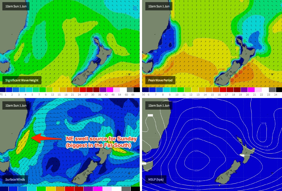
Strong NE winds feeding into Saturday’s developing trough are expected to generate a short range NE swell that’ll certainly be biggest in the southern part of the state on Sunday, however it’ll be smaller in Sydney (and even more so in the northern Hunter, which doesn’t pick up NE swells quite as well).
We’re looking at set waves reaching 2-3ft at NE facing locations throughout the day, but the crucial factor for surf potential on Sunday will be the local winds. At this stage we’re looking at a swing to the north-west, probably in the afternoon - but the timing on this isn’t clear, and it certainly may develop earlier.
That being said, fresh N’ly winds will precede the change so it’ll take some time for the surface to clean up. In any case surf size is expected to reach a peak in the afternoon so there's no need for a dawn session. I would recommend watching the local weather stations (i.e. North Head) like a hawk, and pouncing once you see a directional shift. Keep an eye on the dawn reports too as they’ll have a little more detail.
Next week (June 2-6)
The weekend's developing trough actually has a lot of surf potential however it’s very hard to have a lot of confidence for size in the Sydney, Hunter and Illawarra regions, because the orientation of the fetch isn’t looking especially good.
This is a shame as wind strengths are likely to reach 30kts+ and had the fetch been better positioned, we’d have seen some solid waves - however I fear that we’ll see a peak from this event late Sunday, with a slow easing trend through Monday (albeit clean with offshore winds). The swell direction should also swing a little more E/NE across the region, which will hopefully assist the northern Hunter region in picking up a little more size than Sunday.
Right now I’m happy to go out on a limb and have early size estimates in the 2-3ft range at most NE facing beaches (with smaller surf at south facing beaches), easing slowly during the day. Tuesday looks like seeing smaller waves with similarly clean conditions under a moderate westerly breeze.
From Wednesday through the end of the week we’re on target for a modest short range south swell, originating from the western flank of the trough as it clears to the east. Again, no great size is expected but 2-3ft waves at south facing beaches are a possibility as several pulses of energy all reach their peak across the coast during this three day period (one of which will be originating from a migrating polar low well below Tasmania later Tuesday and into Wednesday).
Longer term (June 7 onwards)
Some models are pointing to a deepening trough in the central/western Tasman Sea late next week and into the weekend that could very well spawn a significant swell generator for southern NSW either next weekend or early in the following week (possibly an ECL too). It’s much too far away to pin down specifics right now but I’ll take a closer look in Monday’s notes.
Comments
Hi Ben. Do you have a high level of confidence in the Model's swell prediction for the South Coast on Monday?