Slow outlook continues

Southern Tasmanian Forecast by Craig Brokensha (issued Wednesday July 23rd)
Best Days: Tomorrow morning for the desperate
Features of the Forecast (tl;dr)
- Small, weak S/SW swell tomorrow AM, easing with W/NW tending S/SW winds
- Tiny inconsistent W/SW groundswell for Fri PM and Sat with N/NW tending N/NE winds Fri, stronger NE tending E/NE Sat
- Tiny surf through Sun/Mon with N/NW tending E/NE winds Sun, N/NW tending variable Mon
Recap
Tiny surf yesterday and today with better options to the east.
This week and next (Jul 24 - Aug 1)
The coming period remains generally tiny, with an inconsistent, flukey W/SW groundswell possibly showing a 1-1.5ft wave during the day Friday/Saturday though local winds will be an issue in any case.
The current synoptic setup isn’t great for swell generation at all.
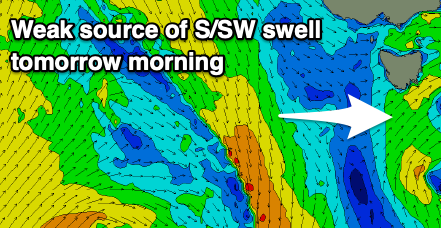
We’ve got a mid-latitude low dipping across us today, with a weak fetch of S’ly winds on its tail expected to produce a weak 1-2ft wave tomorrow morning with W/NW tending S/SW winds.
A secondary, broader mid-latitude low moving across us on the weekend will generate a fetch of strong E/SE winds south of the region Sunday, possibly generating a weak S/SE swell for later in the day/Monday but don’t expect anything of size.
Otherwise a strong low that’s currently in the Heard Island region may again generate 1-1.5ft of inconsistent groundswell for Monday.
Longer term the outlook remains poor, with the only source of decent size expected to originate off a strong low forming across us Wednesday/Thursday. It looks to be localised windswell but more on this Friday.