Fun weekend, tiny next week

Southern Tasmanian Australian Forecast by Craig Brokensha (issued Friday July 18th)
Best Days: Today, tomorrow, Sunday morning
Features of the Forecast (tl;dr)
- Small-mod sized W/SW groundswell tomorrow with strong N/NE tending N/NW winds
- Easing swell Sun with N/NW winds
- Small to tiny, easing surf Mon with N tending strong N/NE winds
Recap
Inconsistent levels of moderate sized W/SW groundswell have provided 3ft sets across Clifton the last two days with mostly clean conditions.
This weekend and next week (Jul 19 - 25)
A general drop in size and consistency is due over the weekend, with our best aligned W/SW groundswells already filling in and peaking, with some smaller, less favourably aligned energy due into tomorrow afternoon.
We should see Clifton coming in around 2ft+ tomorrow, then easing back from 2ft Sunday.
Local conditions will be mostly clean but tomorrow morning will see strong N/NE winds, shifting N/NW into the afternoon with N/NW winds Sunday.
Moving into next week and the weekends’s energy will continue to ease, with possible 1-2ft sets early Monday, tiny through the day and remaining so into the middle of next week.
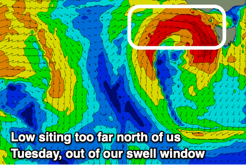
A strong mid-latitude low forming in the Bight will dip south-east through Tuesday but all the swell generating fetch will be aimed into South Australia and Victoria, with nothing left for us.
This will result in tiny surf continuing Wednesday, likely into the end of the week.
Longer term, some renewed mid-latitude frontal activity under the country may generate some small W/SW groundswell for next weekend, but more on this Monday. Have a great weekend!