Make the most of the coming swells
Southern Tasmanian Forecast by Craig Brokensha (issued Monday July 14th)
Best Days: Every day this period (Sunday selected spots)
Features of the Forecast (tl;dr)
- Easing mid-period SW swell tomorrow with N/NW winds tomorrow, smaller Wed with offshore winds
- Moderate sized W/SW groundswell for Thu AM, easing
- Secondary pulse of reinforcing W/SW groundswell Fri, easing slowly Sat
- N/NW tending W/NW winds Thu, N/NW-N Fri, strong N/NE Sat
- Smaller Sun with N/NW winds
Recap
Saturday provided plenty of swell still to the 2ft range with clean conditions, easing back from a smaller 1-2ft yesterday.
This morning we’ve got a fresh pulse of swell from a front moving across us last night, with Clifton coming in at 2-3ft under westerly winds.
This week and weekend (Jul 15 - 20)
The mid-period swell seen today was generated by a strong frontal system moving through overnight and we should see it peaking to 3ft before easing tomorrow from a slightly smaller 2ft to possibly 3ft.
Offshore N/NW winds are expected all day, with Wednesday also clean but smaller.
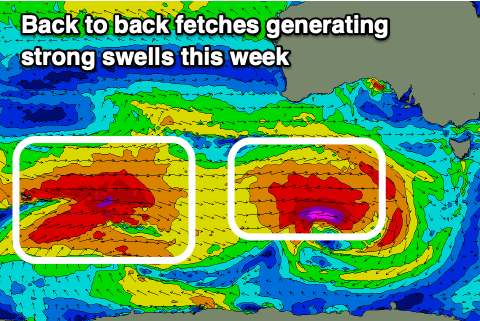
Now, from very late Wednesday but more so Thursday, we’re looking at back to back pulses of strong W/SW groundswell, though the best aligned and most consistent will be the first for Thursday, with reinforcing swells Friday/Saturday not being as favourably aimed.
The source is a great Southern Ocean frontal progression that’s currently around the Heard Island region, with a low spawning off this progression today, generating a great fetch of gale to severe-gale W/SW winds while tracking east.

We should see this swell arriving after dark Wednesday, peaking Thursday morning to 3ft to possibly 4ft across Clifton, easing into the afternoon.
Come Friday, a secondary pulse of less consistent, smaller W/SW groundswell is due, generated by a more elongated by further north located frontal progression passing under the country Wednesday. In saying this we’ll still see W/SW gales generated just within our swell window, with 3ft+ waves likely to continue Friday, easing back slowly Saturday from 2ft to possibly 3ft.
Local winds look good and N/NW tending W/NW through Thursday, N/NW-N all day Friday and then less favourably, strong N/NE on Saturday.
Longer term the outlook is a bit slower so make the most of the coming swells.

