Slight upgrade in coming swells

South Australian Forecast by Craig Brokensha (issued Wednesday July 9th)
Best Days: This afternoon, tomorrow selected locations, Saturday afternoon, Sunday morning, Monday morning
Features of the Forecast (tl;dr)
- Small mid-period SW swell tomorrow with fresh N/NE tending variable winds ahead of a late W/SW change
- Small to tiny Fri with N/NW winds
- Small-mod sized SW tending S/SW swell Sat with strong W/SW winds, easing and tending NW
- Smaller Sun with N/NW winds ahead of a late change
- Small swell for Mon with W/NW tending NE winds
Recap
Yesterday was tiny and this morning we’ve got some new swell on the build, coming in at 1-1.5ft earlier but now 2ft on the sets across Clifton with offshore winds.

New swell this afternoon
This week and next (Jul 10 - 18)

This afternoon’s mix of long-range W/SW groundswell and close-range swell from a tight low forming directly west-southwest of us early this morning are due to hold tomorrow, with the localised low stalling while drifting south through today. This will see an expanding fetch of W/SW winds aimed through our south-western swell window, maintaining 2ft sets tomorrow before fading Friday.
Fresh N/NE winds are due to tend variable through tomorrow ahead of a late W/SW change, clearing into Friday morning.
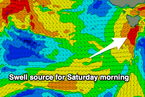
Later in the day Friday, another front moving in and across us looks to generate a fresh spike of short-range W/SW-SW swell for Saturday morning, with an emerging fetch of SW gales likely to generate 2-3ft sets though with strong, morning W/SW winds.
We’re due to see the front clearing during the day and this should steer winds more NW along with a slight drop in size out of the S/SW.
Sunday looks smaller and clean with a N/NW offshore and 1-2ft of easing S’ly swell, with the next swell generating system due to pass through in the evening, though it looks weaker than that of the system Friday night/Saturday.
A short-lived burst of strong S/SW winds don’t look to produce much over 1-2ft for Monday morning, with better swell potential showing later week.
We’re looking at a significant frontal progression moving in from the west mid-late next week, bringing with it some better angled and sizier swell for the South Arm. Tune back in Friday for the latest on these developments.