Good run of surf ahead

Southern Tasmanian Forecast by Craig Brokensha (issued Friday June 27th)
Best Days: Today, tomorrow, Monday, Tuesday, Wednesday morning
Features of the Forecast (tl;dr)
- Moderate sized mix of W/SW-SW groundswells building tomorrow, peaking later, easing slowly Sun
- Reinforcing, moderate sized mid-period swell for later Sun/Mon AM, easing
- N/NW-N winds tomorrow, strong but easing S/SW-SW winds Sun
- N/NW tending N/NE winds Mon
- Moderate sized SW groundswell likely Tue, peaking in the PM with a slightly stronger but less consistent groundswell for Wed AM
- N/NW tending variable winds Tue, N/NW tending S winds Wed
Recap
A good mix of mid-period S/SW swell energy was seen yesterday with favourable conditions all day and sets to 3ft, similar this morning but slowing to the 2-3ft range.
Conditions should remain clean all day again but with easing surf.
This week and next (Jun 28 - Jul 4)
Into the weekend we’ve got two separate pulses of W/SW-SW groundswell due to fill in across the South Arm, generated by a strong, slow moving low that tracked east-southeast towards the polar shelf from the southern Indian Ocean.
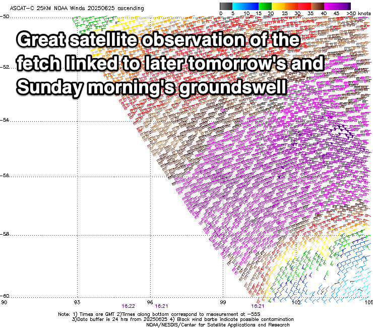
Pre-frontal W/NW-NW gale to severe-gales have generated an initial increase in W/SW groundswell for tomorrow morning, while a stronger and more expansive fetch of severe-gale to sub-storm-force winds have generated a larger kick from the SW later in the day and Sunday morning.
Clifton should come in around 2-3ft tomorrow morning with a stronger pulse later to 3-4ft, easing from a similar if not slightly smaller size Sunday morning.
Trailing frontal activity will then generate some reinforcing mid-period SW swell for later Sunday and Monday morning to 3ft, easing into the afternoon but not likely dropping below 2ft+.
Coming back to the weekend’s conditions and a persistent N/NW-N breeze is due tomorrow, with Sunday still looking poor thanks to a trough bringing a strong S/SW change, easing through the day.
Monday will be clean again with N/NW tending N/NE breezes.
Moving into Tuesday, and an inconsistent SW groundswell is due into the afternoon, ahead of a stronger pulse for Wednesday.
These swells will be generated by back to back fetches along the polar shelf, swinging in from the Heard Island region over the coming days. An initial pre-frontal fetch of W/NW gales will be followed by stronger but tighter, gale to severe-gale W’ly winds.

Tuesday’s swell looks more consistent than Wednesday’s but a little smaller with Tuesday afternoon expected to kick to 2ft to occasionally 3ft, with Wednesday surf more to 3ft.
Local conditions look good with light, morning offshore winds, variable into Tuesday afternoon with more of a sea breeze Wednesday afternoon.
Later week, persistent but slimmer polar fronts moving along the polar shelf look to generate smaller S/SW pulses, but more on this Monday. Have a great weekend!