Great period ahead

Southern Tasmnian Forecast by Craig Brokensha (issued Wednesday June 25th)
Best Days: Every day from tomorrow (besides Sunday)
Features of the Forecast (tl;dr)
- Moderate sized, mid-period S/SW swell easing tomorrow
- New mid-period S/SW swell for later tomorrow but more so Fri AM, easing
- W/NW tending variable winds tomorrow, N/NW tending N-N/NE Fri
- Moderate sized mix of W/SW-SW groundswells building Sat, peaking later, easing slowly Sun and Mon
- N/NW winds Sat, variable later, with S/SW winds Sun
- W/NW tending variable winds Mon
- Moderate sized SW groundswell likely Tue, peaking in the PM with N/NW winds
Recap
The surf was tiny to flat through yesterday while this morning we saw an early calm and heavy rain with 1-2ft of new swell. The onshore change has since hit and with it the swell has kicked more to 3ft with bumpy/lumpy conditions.
This week and next (Jun 26 - Jul 4)
Today’s localised increase in S/SW swell is thanks to a strong, cold low moving across us, bringing with it due to start easing tomorrow but growing out in period as the system moves east.
Clifton should still be 3ft tomorrow morning, while a polar fetch of S/SW gales south of us through last night should maintain similar sized sets later in the day/Friday morning before easing.
Local conditions will improve tomorrow with a W/NW tending variable wind, N/NW tending N-N/NE on Friday.
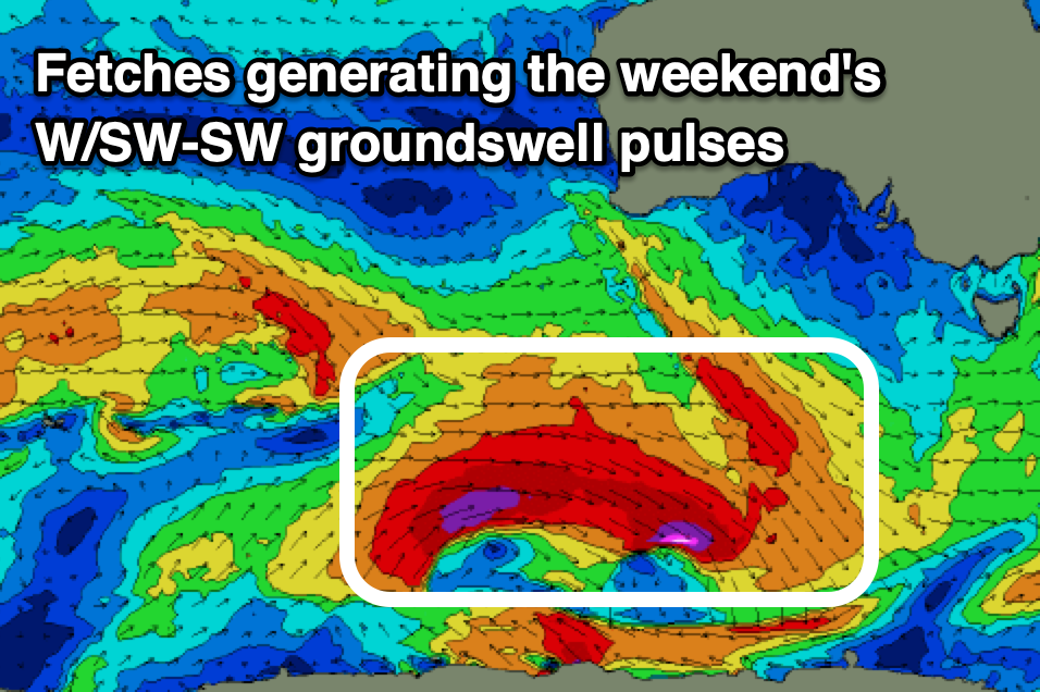
Now looking at the weekend’s W/SW groundswell and the strong polar frontal progression linked to this is currently south-west of Western Australia, with a great fetch of W/SW gales expected to re-intensify on the shelf this evening, projecting severe-gale to near storm-force W’ly winds eastwards, more aligned in our south-western swell window.
This should produce a mix of WSW-SW groundswells for Saturday, building towards a peak later to 4ft across Clifton, with the morning due to come more in around 3ft.
A secondary fetch of severe-gale W/NW winds pushing through Friday should maintain the size on Sunday to 3ft to possibly 4ft, easing slowly Monday from 2-3ft thanks to another, weaker trailing front moving in behind all the activity.
Winds for this swell look great Saturday with a persistent, weakening N/NW breeze due, while a trough now looks to bring a S/SW change Sunday. Monday looks cleaner with a light W/NW offshore, variable into the afternoon.
Longer term, another good SW groundswell is due into Tuesday afternoon/Wednesday, generated by a strong but distant polar frontal system moving in from the Heard Island region. More on this and further S/SW swells later week on Friday.