Great surf from later week

Southern Tasmanian Forecast by Craig Brokensha (issued Monday June 23rd)
Best Days: Thursday, Friday, Saturday, Sunday morning
Features of the Forecast (tl;dr)
- Building S/SW windswell Wed PM, easing Thu while maturing
- Strengthening W/SW tending SW-S/SW winds Wed, W/NW tending variable Thu
- Moderate sized S/SW groundswell later Thu, peaking Fri AM easing
- N/NW tending variable winds Fri
- Moderate + sized W/SW groundswell for Sat and early Sun AM
- N/NW winds Sat, W/NW tending S Sun
Recap
The weekend started tiny but into Saturday afternoon some new W/SW groundswell filled in with 1-2ft sets under variable winds.
This swell eased into yesterday morning with slower waves under offshore winds, tiny today though still 1-1.5ft.
This week and weekend (Jun 24 - 29)
The outlook for this week isn’t great until the latter stages, with tomorrow expected to stay tiny ahead of a building S/SW windswell Wednesday as a strong mid-latitude frontal progression moves in and across us.
It won’t be the fetches generated just south of WA and SA that will bring swell, rather the tail of a low moving across us, with a localised fetch of strong S/SW winds due to kick up 3-4ft of windswell into the afternoon along with strong W/SW tending SW-S/SW winds.

This windswell is expected to grow out to stronger mid-period energy and ease into Thursday as winds quickly swing back to the W/NW, even tending variable into the afternoon.
Size wise, Clifton should ease from 3ft, but into the afternoon a new pulse of S/SW groundswell is due, generated by a stalling fetch of S/SW gales to our south-southwest tomorrow and Wednesday morning.
A late kick to 2-3ft is due Thursday, easing from 3ft Friday morning and with N/NW winds.
Looking at the weekend outlook, and our good groundswell flagged through last week is on track.
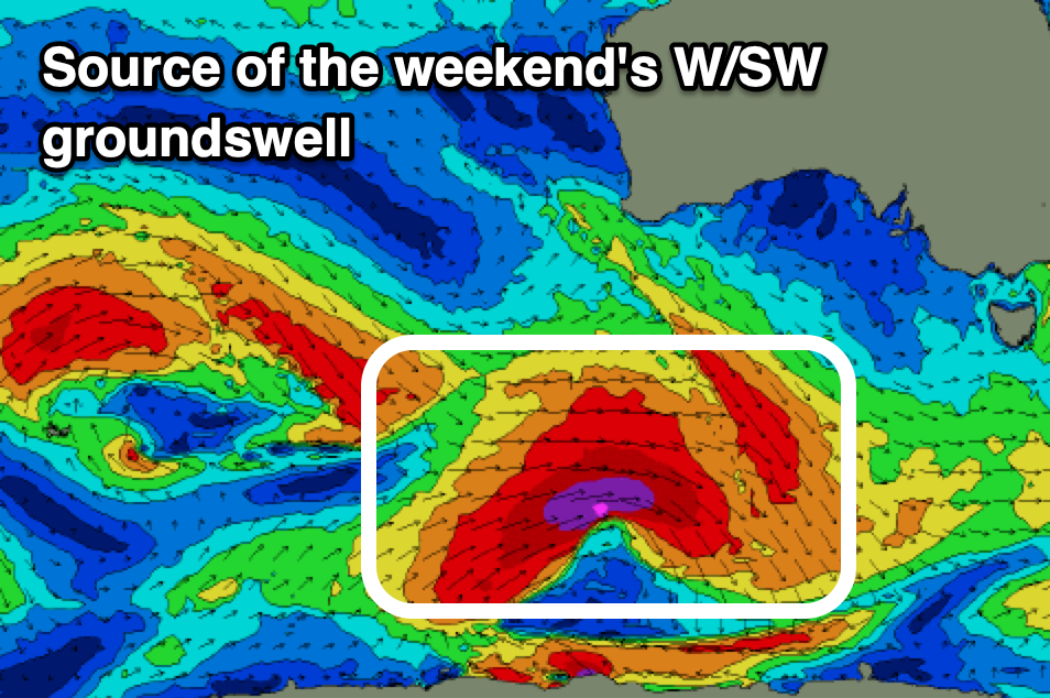
A strong mid-latitude low that’s currently south-east of Madagascar is generating gale to severe-gale S/SW winds, aimed out of our swell window, but it’s due to track east-southeast over the coming days while strengthening.
As the low continues south-east towards the polar shelf, it’s due to strengthen south of WA this Wednesday/Thursday, with a great fetch of severe-gale to possibly storm-force W’ly winds being projected through our swell window.
A moderate + sized W/SW groundswell is due from this low, peaking Saturday to 3-4ft under great, N/NW winds, easing from a similar size Sunday under a W/NW tending S’ly breeze as a trough clips us.
Longer term the outlook remains active but more on this Wednesday.