Tricky end to the week, better weekend

Southern Tasmanian Forecast by Craig Brokensha (issued Wednesday May 28th)
Best Days: Tomorrow morning, Saturday, Sunday
Features of the Forecast (tl;dr)
- Easing S windswell tomorrow with some small, building mid-period energy. W/NW tending SW winds
- Moderate sized, mid-period SW swell building Fri with W/SW winds (possibly W/NW at times)
- Stronger S/SW groundswell Sat AM, easing, smaller Sun
- N/NW tending variable winds Sat, N Sun
Recap
Yesterday was tiny and clean, while today the backside of a mid-latitude low has brought strong onshore winds and a localised swell to 2-3ft.
This week and next (May 29 - Jun 6)
Today’s increase in localised swell will ease back through tomorrow with small 2ft leftovers due across Clifton under a W/NW offshore, shifting SW into the afternoon but without much strength.
Into Friday, a mix of building mid-period SW swell is due, with a larger S/SW groundswell possibly showing on dark, before easing Saturday morning.
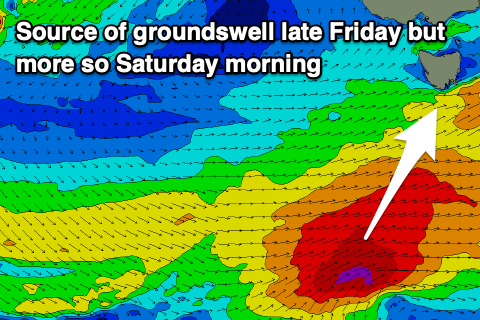
Both swells will be generated by a strengthening polar frontal progression south-west of us today, with the strongest swell generating winds firing up south of us tomorrow afternoon/evening.
This will result in the strongest swell energy arriving late Friday but more so after dark, with Saturday seeing the most size. Ahead of this, building mid-period energy is expected Friday, increasing to 3-4ft through the day but with W/SW winds. There’s a chance for W/NW breezes at times, but Saturday will be best with stronger, easing levels of S/SW groundswell from 4ft and a light N/NW tending variable breeze.
Sunday will be half the size but likely still 2ft with clean conditions again under a persistent N’ly breeze.
Longer term, next week looks mostly poor with no real size early week, while a trough will bring S’ly winds and a localised windswell Tuesday/Wednesday. A flukey SE groundswell due at the same time doesn’t look to have any size so try the East Coast for more options.