Strong swell to end the week

Southern Tasmanian Forecast by Craig Brokensha (issued Monday May 26th)
Best Days: Friday protected spots, Saturday, Sunday morning
Features of the Forecast (tl;dr)
- Tiny tomorrow with NW tending strong SW winds
- Poor localised windswell Wed with strong SW winds
- Easing swell Thu with W/NW tending SW winds
- Moderate + sized S/SW groundswell building Fri, peaking in the PM, easing on the weekend
- Mod-fresh W-W/SW winds Fri (W/NW at times likely during the AM)
- N/NW tending variable winds Sat
Recap
A good dose of rain was seen Saturday morning with variable winds and plenty of swell hanging in the mix from Friday, easing through the day.
Yesterday was smaller again and only for bigger boards, tiny today.
This week and weekend (May 27 - Jun 1)
As touched on last week, a strong mid-latitude low that’s currently moving through the Bight is too far north to generate any swell for us, with a localised windswell due Wednesday as the low moves across us.
This will result in clean, tiny surf tomorrow morning while into the afternoon and Wednesday we’ll see strong SW winds and poor conditions.
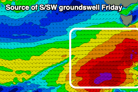
Of more impatience is a solid run of S/SW groundswell due into the end of the week as a strengthening polar frontal progression fires up to our south-west Wednesday evening and Thursday.
A great fetch of gale to severe-gale W-W/NW winds will generate a moderate + sized S/SW groundswell for Friday, building through the day and likely reaching 4-5ft into the afternoon.
Winds are a little dicey and likely W-W/SW through the day, but we might see periods of W/NW breezes especially in the morning as the swell builds, with clean conditions and easing surf Saturday from a solid 4ft under N/NW breezes.
The swell will continue to fade through the weekend and into early next week, with some rare S/SE groundswell on the cards for mid-next week. More on this Wednesday.