Fun surf tomorrow, and then on the weekend

Southern Tasmanian Surf Forecast by Craig Brokensha (issued Monday February 19th)
Best Days: Tomorrow morning, Sunday morning
Features of the Forecast (tl;dr)
- Easing W/SW-SW swell tomorrow with moderate to fresh N/NE tending strong E/NE winds
- Tiny, fading swell Wed with similar winds to Tue
- Weak W/SW-SW swell for Sat with strong SW winds
- Easing swell Sun with N/NW winds ahead of sea breezes
Recap
Clean but tiny surf Saturday with a bit more energy for yesterday with clean conditions.
Today, even more swell has been seen with the arrival of a new mid-period W/SW swell but with average winds thanks to the swell generating front moving through with it. There's also some S/SE groundswell in the mix but that's hard to decipher.
This week and weekend (Feb 20 - 25)
Today's kick in swell will ease into tomorrow and clean up with fun 2ft sets due across Clifton with a moderate N/NE offshore, strengthening from the E/NE into the afternoon.
Similar winds are due Wednesday but with the swell fading back from the 1ft range or so.
We then look to a significant low firing up west of us during the week, as touched on in Friday's notes.
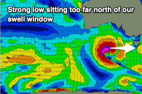
Unfortunately, for the near entire lifetime of the low, we'll see it sitting too far north of our swell window, with some weak, localised W/SW-SW swell due into the weekend as the low moves across us while weakening.
This looks to be with average winds as well, strong SW on Saturday with 2ft to maybe 3ft of swell, better Sunday and around to the N/NW with easing 1-2ft sets.
Longer term the outlook is active with increasing Southern Ocean storm activity into the middle to end of next week. More on this Wednesday.